3.7 mile loop through grassland and chaparral, at a preserve which was a former coal mine.
Distance, category, and difficulty:
This 3.7 mile loop hike is on the moderate side of easy. Trailhead elevation is about 740 feet. The featured hike climbs to about 1250 feet, then descends back to the trailhead. Total elevation change is about 1145 feet.
Exposure:
Mostly exposed, with some shade.
Trail traffic:
Moderate.
Trail surfaces:
Dirt fire roads and trails.
Hiking time:
2 hours.
Season:
Too hot in summer. Best in late winter and early spring.
Getting there:
• From CA 4 in Contra Costa County exit Somersville Road (exit 26a eastbound/26 westbound). Drive south on Somersville to the park entrance.
• If you're driving from San Francisco, or the south bay, these directions may make your trip quicker (or at least more pleasant): from the CA 24/Interstate 680 interchange in Contra Costa County, exit Ygnacio Valley Road (exit 46b). Drive east on Ygnacio Valley Road about 8 miles, then the road changes into Kirker Pass. Continue about 5 miles on Kirker Pass to the junction with Buchanan. Turn right and drive about 3 miles to Somersville Road. Turn right and drive to the park entrance.
GPS Coordinates* for Trailhead:
Latitude
Longitude
(* based on Google Earth data, shown as degrees, minutes, seconds)
Gas, food, and lodging:
Gas, stores, and restaurants back on Buchanan. Camping info from EBRPD: "There are two camping areas in Black Diamond Mines Regional Preserve. Reservations are required for both--call (510) 562-2267. Neither camping area has water, so water must be transported in. Star Mine Group Camp Area, available during spring, summer and fall, is for organized, educational groups only. It can accommodate up to 40 people. It is located in a grassland/oak woodland community at the eastern edge of the Preserve. Overnight camping is limited to two nights. Parking (maximum eight cars), picnic tables and a pit toilet are available at the site. Campers must bring in their own water and haul out their own garbage. Stewartville Backpack Camp is for the general public. The fee is $5 per night per person. Camping is limited to two nights during the spring, summer and fall. There is room for 20 campers. Picnic tables and a pit toilet are available, as well as water for horses (not for human consumption). The camp is located 3.2 miles from the Preserve headquarters, near the Stewartville and Upper Oil Canyon trails."
Trailhead details:
Once inside the park, you can stop at the park office for a map or help with planning a hike. Then get back into your car and drive to the trailhead at the end of the road. Entrance fee of $5 charged when entrance kiosk is staffed. $2 dog fee. Drinking water, maps, and vault toilets at trailhead. Large parking lot. Emergency phone at park office. There are designated handicapped parking spots; trails are wheelchair accessible but most are steep and some present barriers. There is no direct public transportation to the park, but you can walk (or cycle) to the trailhead from the Tri Delta Transit route 390 bus stop: visit the Tri Delta Transit website for details.
Rules:
Most trails are open to hikers, equestrians, and cyclists, but a few trails are designated hiking-only. Dogs are permitted -- rules here. Park is open from 8 a.m. to dusk.
The Official Story:
EBRPD's Black Diamond Mines page.
Park headquarters 925-757-2620
Map/Book Choices:
• Map from EBRPD
• Geology Trails of Northern California, by Robin C. Johnson and Dot Lofstrom (order this book from Amazon.com) has a nice geological description of this preserve.
Go to Bay Area Hiker Home page
Black
Diamond Mines Regional Park was, once upon a time, ranch land like much of the east bay (of course, before that
it was populated with Native Americans). When in the 1860s coal was discovered
at this parcel of land just south of Pittsburg, extensive mining took
place, with nearly 4 million tons of "black diamond" removed
from the earth. When coal use dropped off around the turn of the century,
the land was mined for sand. More than 1.8 million tons of the stuff was
removed. In spite of all that has been taken away, Black Diamond Mines
is remarkable for what remains. An over 5,000 acre park, Black Diamond
 Mines boosts 65 miles of trails through grassland, chaparral, and oak
savannah, and past sandstone rock formations. If one day at Black Diamond
Mines isn't enough, a backpack and separate group camp make it possible
to linger a little longer.
Mines boosts 65 miles of trails through grassland, chaparral, and oak
savannah, and past sandstone rock formations. If one day at Black Diamond
Mines isn't enough, a backpack and separate group camp make it possible
to linger a little longer.
Spring is the optimal time of year for a
visit, although the blue oaks are lovely in autumn, and the manzanitas are
stunning in winter. Springtime brings carpets of flowers, fresh oak leaves,
and soft warm temperatures. If you wish to learn more about the mining
history of Black Diamond Mines, you can stop by the Underground Mining
Museum, and/or hike to the remains of the mines. Most mine entrances are
barred, but bring a flashlight to explore 200 feet of Prospect Tunnel's
400-foot passage. If you're just interested in the trails, you'll have
plenty to choose from. Short loops originate at the main trailhead, as
well as the park office trailhead, and the entrance at Contra Loma Regional
Park. Longer hikes of 8-10 miles are possible as well. If you visit once
and are hooked like me, you'll have lots of map fun planning your next
hike at Black Diamond Mines.
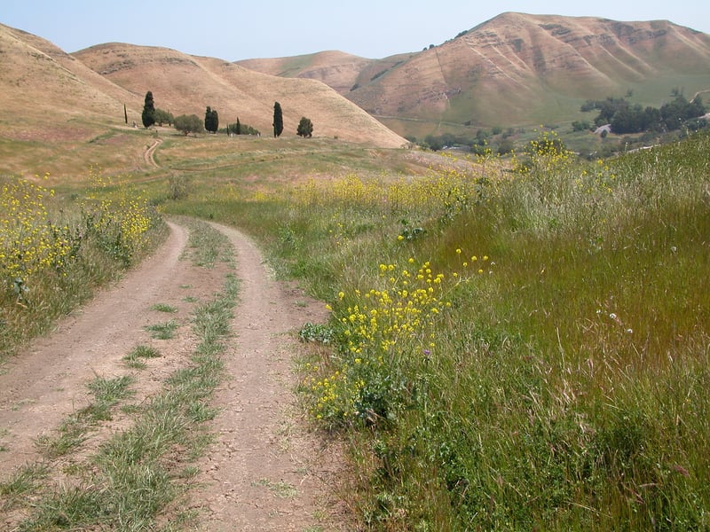
Start at the gate near the information
 signboard at the end of the parking lot. Walk uphill on the broad multi-use
Nortonville Trail. At about 250 feet, the trail crests at a signed junction. Turn left
on Stewartville Trail, open to hikers, equestrians, and cyclists.
A few steps later, you'll reach a signed junction
with Railroad Bed Trail. Continue straight on Stewartville Trail.
The grade is initially level, but after passing a junction with the Pittsburg
Mine Trail on the right, Stewartville Trail begins to climb. The trailside grassland
hosts owl's clover, fiddlenecks, and ithuriel's spear in spring. At about
0.7 mile, Stewartville Trail attains its peak elevation and reaches a
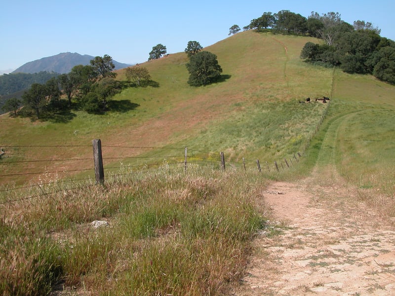
signed junction just before a cattle gate. Turn right on Ridge Trail.
signboard at the end of the parking lot. Walk uphill on the broad multi-use
Nortonville Trail. At about 250 feet, the trail crests at a signed junction. Turn left
on Stewartville Trail, open to hikers, equestrians, and cyclists.
A few steps later, you'll reach a signed junction
with Railroad Bed Trail. Continue straight on Stewartville Trail.
The grade is initially level, but after passing a junction with the Pittsburg
Mine Trail on the right, Stewartville Trail begins to climb. The trailside grassland
hosts owl's clover, fiddlenecks, and ithuriel's spear in spring. At about
0.7 mile, Stewartville Trail attains its peak elevation and reaches a
signed junction just before a cattle gate. Turn right on Ridge Trail.
Ridge Trail starts out open to equestrians,
cyclists, and hikers, but a sign warns that there's no outlet for horses
and bikes ahead, as the trail enters a sensitive ecological area where
only hikers are permitted. There are nice views down into the valley to
the southeast, and a peek at Mount Diablo to the west. Ridge Trail climbs for a few feet, then dips down and contours
levelly around a hill. If you're hiking in late winter, you'll likely
see Padre's shooting stars nestled in the grass. Later in spring, lupines,
buttercups, and fiddlenecks are plentiful. Buckeyes and blue oaks pepper
 the hillsides. On the left of the trail, look for the delicate white blossoms
of woodland star in spring. On a clear day, views unfold to the right,
all the way past the bay to Solano County. Ridge
Trail begin to climb, and passes through a cattle gate. Look on the left
for lots of bluedicks and a few owl's clover in early spring. Continuing
to ascend, you might notice a change in the trailside vegetation. Oaks
are still present, but the manzanitas seem out of place. And these aren't
stunted shrubs, but full-size and even tree-size specimens. This shift
in vegetation continues, and you'll reach a hilltop, at about 1195 feet,
with more manzanitas and coulter pines. Also look for yerba santa and stunning red paintbrush blooming in early spring.
On the left, a bare sandstone ledge provides the perfect rest stop. The
view down into the valley is just incredible. This has to be one of my
favorite bay area vistas. A verdant valley is dotted with ponds, and sheltered
on both sides by hills. Chaparral lines the slopes on the west, while
the eastern hills are shaded by oaks. A longer view to the west reveals
the high peaks of Mount Diablo. When I visited on a breezy spring day,
the winds rustled through the Coulter pines, and I felt very far area
from the bay area. When you're ready, continue on Ridge Trail, which begins
the hillsides. On the left of the trail, look for the delicate white blossoms
of woodland star in spring. On a clear day, views unfold to the right,
all the way past the bay to Solano County. Ridge
Trail begin to climb, and passes through a cattle gate. Look on the left
for lots of bluedicks and a few owl's clover in early spring. Continuing
to ascend, you might notice a change in the trailside vegetation. Oaks
are still present, but the manzanitas seem out of place. And these aren't
stunted shrubs, but full-size and even tree-size specimens. This shift
in vegetation continues, and you'll reach a hilltop, at about 1195 feet,
with more manzanitas and coulter pines. Also look for yerba santa and stunning red paintbrush blooming in early spring.
On the left, a bare sandstone ledge provides the perfect rest stop. The
view down into the valley is just incredible. This has to be one of my
favorite bay area vistas. A verdant valley is dotted with ponds, and sheltered
on both sides by hills. Chaparral lines the slopes on the west, while
the eastern hills are shaded by oaks. A longer view to the west reveals
the high peaks of Mount Diablo. When I visited on a breezy spring day,
the winds rustled through the Coulter pines, and I felt very far area
from the bay area. When you're ready, continue on Ridge Trail, which begins
 to descend. The flowers of winter's Indian warrior give way to the cheerful
yellow blossoms of bush poppy as spring rolls around. Ridge Trail curves
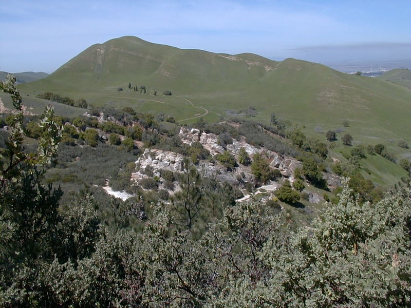
to the left away from a dropoff, revealing sandstone rock formations down
the hill. At 1.4 miles, Ridge Trail ends at a signed junction. Continue straight on Chaparral Loop Trail.
to descend. The flowers of winter's Indian warrior give way to the cheerful
yellow blossoms of bush poppy as spring rolls around. Ridge Trail curves
to the left away from a dropoff, revealing sandstone rock formations down
the hill. At 1.4 miles, Ridge Trail ends at a signed junction. Continue straight on Chaparral Loop Trail.
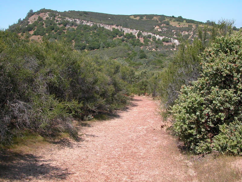
To the west, past a low-slung sandy knoll, a prominent reeflike hill rises, with rocks jutting out at an angle. The trail rises to a power tower, then begins a descent. A few stretches are aromatic alleys, with sweet smells wafting from manzanita blossoms (winter), black sage and pitcher sage flowers (spring), and a froth of chamise blooms (summer). A few live oaks mingle with pine and yerba santa as the Chaparral Loop Trail drops on steps and some steep grades into Manhattan Canyon. In mid-May, I have seen dozens of fairy lanterns blooming along the trail. Just after a bridge crosses the canyon at 1.8 miles, you’ll reach a junction, with the trail to the right closing the Chaparral Loop. Turn left, following the sign toward Manhattan Canyon Trail. After a brief, winding climb through chamise and six-foot-tall manzanitas, there’s a second junction. Manhattan Canyon Trail, to the right, leads first uphill, then downhill back toward the trailhead. Turn left onto Manhattan Canyon Trail.
On a slope just uphill from the canyon floor, the narrow trail ascends through live oaks, pine, sticky monkeyflower, toyon, and manzanita. Somewhat abruptly, the canyon widens into a grassy bowl near the park boundary. Blue oaks dot the hillsides as the Manhattan Canyon Trail veers right and climbs steeply, ending at a junction with Black Diamond Trail at 2.15 miles. A bench to the right just before the junction is a good place to catch your breath. Turn right onto Black Diamond Trail.
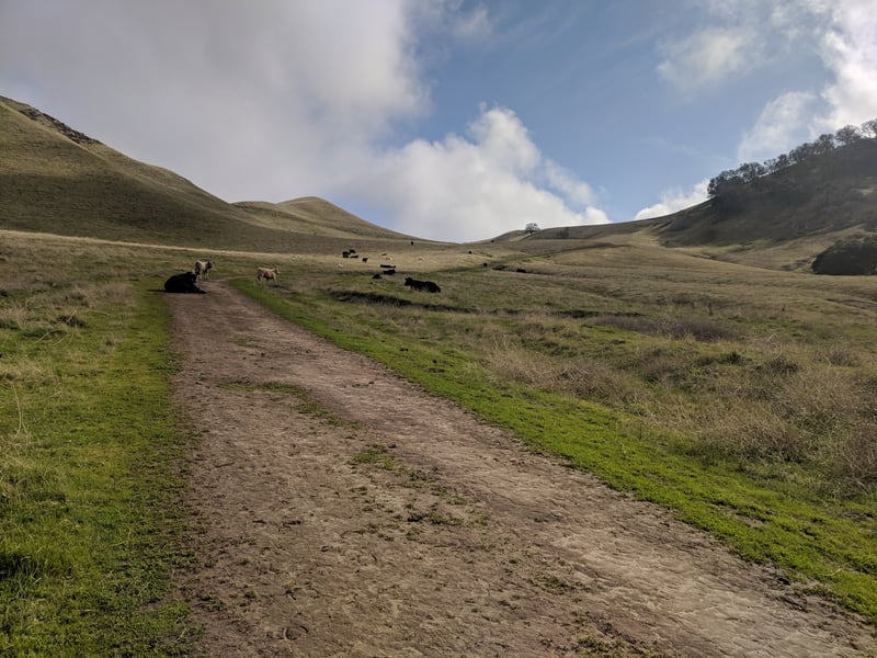
Trailside vegetation is a mixture of grassland, pine, manzanita, and blue and live oaks. Look off to the right for views back to Chaparral Loop and Ridge trails. After a brief level interlude, the fire road begins to descend easily into chaparral, where you might see ceanothus, black sage, yerba santa, chamise, and pitcher sage. At 2.35 miles, the connector to the Manhattan Canyon Trail departs on the right. Continue straight on Black Diamond Trail, ascending at a moderate grade back into grassland. On the far side of a cattle gate beneath a power tower, there are sweeping views to Stewartville Trail. By mid-May, the tips of high hills rising up to the northeast begin to fade from green to dull brown, drained of color. In early spring, shooting stars bloom in staggering numbers along the trail, in the grassy breaks between clusters of blue and live oaks. Black Diamond Trail begins to descend easily, offering views northwest to Suisun Bay on clear days. At 2.9 miles, Black Diamond Trail ends at a junction with Nortonville Trail. Turn right.
Nortonville Trail, open to hikers, equestrians,
and cyclists, descends through grassland. Look for owl's clover, redmaids,
and lupines in the spring. A path to the left departs to visit Rose Hill
Cemetery, an optional side trip. At 3.3 miles, you'll reach a signed
junction with one of the legs of Manhattan Canyon Trail. Continue straight.
Nortonville Trail passes through a cattle gate, and at 3.35 miles, encounters
the second leg of Manhattan Canyon Trail. Continue straight.
Red winged blackbirds are plentiful here, especially
on the left side of the trail in a marshy area. Descending at a gentle
pace, the trail reaches a signed junction at 3.6 miles, with the most
commonly visited area of the park, the Underground Mining Museum (another
optional side trip). Continue straight on Nortonville Trail, under
a few blue oaks, past the previously encountered junction with Stewardville
Trail, and return to the trailhead.
Total distance: 3.7 miles
Last hiked: Tuesday, March 27, 2001