Las
Trampas Regional Wilderness is the tough guy of the East Bay Regional Park District. There
are no steam trains or petting zoos. Just steep, rugged trails, interesting
geology, and fantastic views.
Las Trampas (Spanish for the traps) has
two distinct areas, each with its own personality. Rocky Ridge, on the
west side of the valley, is known for views in all directions, unusual
rocks, and green rolling hills lightly forested with California bays and
oaks. The wildflower display on the hills just off the ridgeline
is an east bay favorite. The Las Trampas Ridge, to the east, is quite
different, featuring a plant community dominated by chamise, with other
chaparral plants such as manzanitas and coyote brush. On the Rocky Ridge
side, there are two trails that climb to the ridgeline, Elderberry and
 Rocky Ridge, and all loop hikes make use of at least one of these trails.
On the Las Trampas Ridge side, there are many loop possibilities, most of them long, tough hauls. A 7-mile loop that covers
both sides of the ridge combines Chamise, Mahogany, Trapline, Sulfur Springs,
Amigo, Virgil Williams, Madrone, Corduroy Hills, Las Trampas Ridge, and
the Bollinger Canyon Trails. The shortest loop
strings together Chamise and Mahogany Trails, a 1 mile hike. The easiest
loop of all at Las Trampas combines the Bollinger Canyon and Creek Trails,
a nearly flat 1.2 mile hike. Las Trampas is sun-baked in the summer, and
the trails are annoyingly muddy in the winter and early spring (especially
in areas where the cattle graze). The best season is spring, after the
trails have dried out a bit, but before it becomes hot.
Rocky Ridge, and all loop hikes make use of at least one of these trails.
On the Las Trampas Ridge side, there are many loop possibilities, most of them long, tough hauls. A 7-mile loop that covers
both sides of the ridge combines Chamise, Mahogany, Trapline, Sulfur Springs,
Amigo, Virgil Williams, Madrone, Corduroy Hills, Las Trampas Ridge, and
the Bollinger Canyon Trails. The shortest loop
strings together Chamise and Mahogany Trails, a 1 mile hike. The easiest
loop of all at Las Trampas combines the Bollinger Canyon and Creek Trails,
a nearly flat 1.2 mile hike. Las Trampas is sun-baked in the summer, and
the trails are annoyingly muddy in the winter and early spring (especially
in areas where the cattle graze). The best season is spring, after the
trails have dried out a bit, but before it becomes hot.
For the featured hike, start at the western
edge of the parking lot, near the shady picnic area. Enter the park
by the large metal gate, walk across the grass, then pass through the
cattle gate onto Elderberry Trail. Right away you'll get a
sense of the trail quality. If
the surface is squishy, muddy, and/or rutted, expect the same from the
rest of the trail. To the east Chamise Trail is visible as it switchbacks
uphill. Elderberry Trail dips to cross over (through
may be a better word) the first of many seasonal creeks near a buckeye
tree. After leveling out across a meadow,
the trail passes a corral and reaches a signed junction, at 0.4 mile.
Turn right to remain on Elderberry Trail.
The trail climbs sharply uphill, first under
coast live and California bays near a creek, then
emerging into grassland with views up to the ridge. After the initial
climb, the trail curves slightly south and tapers out a bit, but there are several steep ups and downs on the way to the ridge. The worst
muddy sections occur where the trail dips
 down to shaded creek crossings, and then climbs back
up. I've hiked through here when the mud has been that industrial strength
shoes-sucked-off-your feet quality. It's
not too much fun, but those stretches are brief, and the trail returns
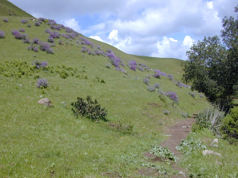
to the grassland and all is forgiven, for now. Along the trail in spring you
may see paintbrush, purple bush lupine, and California poppy. Sunny stretches
harbor sagebrush, coffeeberry, and poison oak. Where the trail is deeply
shaded, gooseberry bushes flourish along with nettles, beneath California
bays and a few maples. At 1.2 miles, a shortcut path (not on the map)
departs uphill to the right. Continue straight on Elderberry Trail, which continues to rise and fall through trees and grassland. Look for deer, coyote, and bobcat tracks at the muddy spots. Elderberry Trail crosses through a pretty California bay grove, then winds through the grassland and makes a final
steep push to the ridge line. On a mid-April
hike, I saw filaree, fiddleneck, California poppy, and creamcups on the
hill to the right. Elderberry Trail ends at a signed junction at 2 miles. From the junction, savor the views east, of Mount Diablo. There's a short trail to the south that dead-ends
at a belvedere (with a much-appreciated bench to catch your breath), but take Rocky Ridge View Trail uphill to the right.
down to shaded creek crossings, and then climbs back
up. I've hiked through here when the mud has been that industrial strength
shoes-sucked-off-your feet quality. It's
not too much fun, but those stretches are brief, and the trail returns
to the grassland and all is forgiven, for now. Along the trail in spring you
may see paintbrush, purple bush lupine, and California poppy. Sunny stretches
harbor sagebrush, coffeeberry, and poison oak. Where the trail is deeply
shaded, gooseberry bushes flourish along with nettles, beneath California
bays and a few maples. At 1.2 miles, a shortcut path (not on the map)
departs uphill to the right. Continue straight on Elderberry Trail, which continues to rise and fall through trees and grassland. Look for deer, coyote, and bobcat tracks at the muddy spots. Elderberry Trail crosses through a pretty California bay grove, then winds through the grassland and makes a final
steep push to the ridge line. On a mid-April
hike, I saw filaree, fiddleneck, California poppy, and creamcups on the
hill to the right. Elderberry Trail ends at a signed junction at 2 miles. From the junction, savor the views east, of Mount Diablo. There's a short trail to the south that dead-ends
at a belvedere (with a much-appreciated bench to catch your breath), but take Rocky Ridge View Trail uphill to the right.
With unobstructed views to the southwest, Rocky
Ridge is the best site for a glimpse of the East Bay M.U.D. property that
is largely closed to the public. From this ridge soft-looking hills roll
downhill to Upper San Leandro Reservoir, and end at Anthony Chabot Regional
Park. A few trails are open to the public, but you must obtain a trail
use permit from East Bay M.U.D. before heading out on any trails. I've
been pinning to hike from Las Trampas to the Chabot Staging Area for a
few years, but it's a long trek; about 9 miles one way.
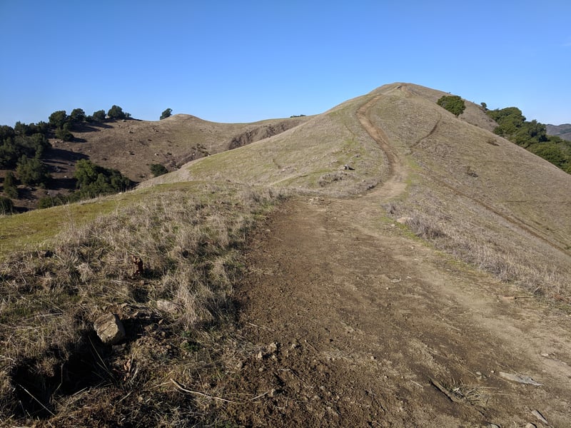
Rocky Ridge View Trail climbs steeply through the grassland, to a series
of crests. It may be windy along the ridge. Once on a March hike, I watched a UFA (unidentified frolicking animal) across the canyon to the west. I had forgotten my binoculars, but could see the large dark creature was unaccompanied by a human. Bigger than a coyote or a bobcat, could this be the mythical black panther?
You might notice a rocky reef
jutting out of the ground on the left side of the trail. Take a close
look. These rocks from the Orinda Formation hold remnants of ancient
beach and
 shoreline. Shells are visible embedded in some of them. At 2.3 miles,
Devil's Hole Trail departs to the left at a signed junction. If you want
to extend your hike, Devil's Hole Trail drops down the west side of Rocky
Ridge and passes the wind caves, an ominous-looking cluster of rocks (it's
shown on my old Olmsted map, but not on the EBRPD map). Then Sycamore Trail
climbs back to the ridgeline and adds about 2.5 miles to the featured
hike. Today, continue straight on Rocky Ridge View Trail.
shoreline. Shells are visible embedded in some of them. At 2.3 miles,
Devil's Hole Trail departs to the left at a signed junction. If you want
to extend your hike, Devil's Hole Trail drops down the west side of Rocky
Ridge and passes the wind caves, an ominous-looking cluster of rocks (it's
shown on my old Olmsted map, but not on the EBRPD map). Then Sycamore Trail
climbs back to the ridgeline and adds about 2.5 miles to the featured
hike. Today, continue straight on Rocky Ridge View Trail.
After a steady climb along the ridge, Upper
Trail descends along the east side of the hill. On a breezy day, you'll
be glad for a respite from the wind. The grade levels out, and at 2.8
miles, Cuesta Trail departs on the right side of the trail from a signed
junction. Either Cuesta or Rocky Ridge View Trail is an option here. Rocky Ridge View continues
along the ridgeline, while Cuesta angles along the hillside beneath the ridge (in winter spare yourself from the mud and take Rocky Ridge View). For the featured hike, turn right onto
Cuesta.
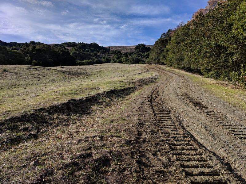
Cuesta is open to hikers and equestrians only.
The narrow path initially doubles back to the south, descending steeply
through coyote brush, then turns and heads north. The trail has some dips
up and down along the way, but mostly follows a downhill course. Cows
use the path frequently, so even though it traverses an exposed slope,
sections of Cuesta are soggy and rutted in winter and early spring. Views
of Mount Diablo and Las Trampas Ridge accompany your descent. Ignore unofficial paths heading back down to Elderberry Trail on the right side of the trail.
In late winter, milkmaids, California poppies,
California buttercups, and shooting stars enliven the green grass. Later,
in spring, you might see woodland star, purple bush lupine, mule-ear sunflowers, fiddlenecks, and creamcups. California bays are the dominant
tree, flourishing in the damp creases of the hills. Beware a social (cow? deer?) path that heads straight where the real trail curves right and downhill, at 3.6 miles. This path starts out fine, but then deteriorates. Cuesta makes
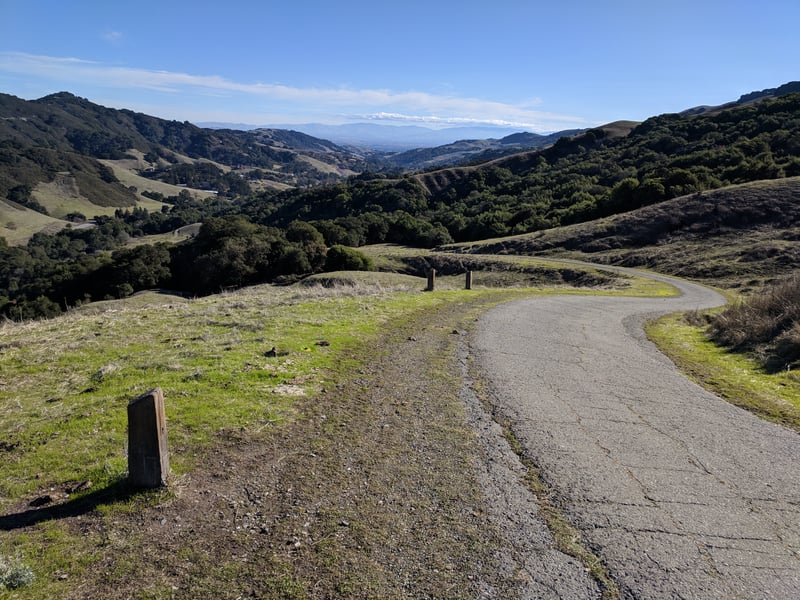
a final descent to a signed junction at 4.2 miles. Paved Rocky Ridge
Road ascends from here to the ridge; according to the map a small dirt path runs along it,
offering an optional route for hikers -- last time I was here I didn't see the side path at all. Turn right onto Rocky Ridge View Trail.
Although the trail is wide and paved, it's
closed to cyclists. Rocky Ridge View Trail is popular with folks exercising
and walking dogs; the moderately steep grade ensures a good workout. As
you descend through the grassland bordered by coast live oaks, there are
nice views right, uphill to Rocky Ridge, and left, to Las Trampas Ridge.
Rocky Ridge Road ends at a cattle gate, back at the trailhead.
Total distance: 4.7 miles
Last hiked: December 7, 2018
Previous visit: April 17, 2002 and March 15, 2000