At
the Hacienda Trailhead to Almaden Quicksilver County Park, you're
bombarded with warning signs. Don't eat the fish (too much mercury
in the water). Don't hike off trail (old mine shafts and whatnot). Don't
climb on any structures (they're old, and also may harbor rodents with
Hanta Virus!). But don't be daunted, because this is a large and
spectacular park with abundant hiking trails and a fascinating history.
Almaden Quicksilver occupies
the site of the first mining enterprise in California (check out the historical
marker across the street from the Hacienda Trailhead entrance). It
became the richest mercury mine in North America, and the most productive
mine in California history. Cinnabar, a mineral composed of sulfur
and mercury, was used by the Ohlone Indians for painting and religious
ceremonies. They introduced cinnabar to early settlers, who heated the
mineral to release the mercury. You may know of mercury as the silver
stuff in old thermometers, but it's also essential to the mining of gold and silver, and historically was used
in the production of hats (think "mad as a hatter"). Quicksilver
 is another word for mercury, referring to its liquid properties (it's
the only metal that is liquid at room temperature) and shiny silver color. Mining
began here in the 1840's, and the New Almaden Mines (later, after a shift
in ownership the name was changed to the Quicksilver Mining Company) became
a thriving area with several settlements, including Englishtown and Spanishtown,
a company store, and school. By 1865 there were 700 buildings, and 1,800
people living on Mine Hill. By 1927, with the cinnabar largely depleted,
large-scale mining ceased and a only few small operators continued to
process mercury. When, in the 1970's, mercury was found to be an
environmental toxin, all mining ceased. Santa Clara County acquired
the first parcel of what is now Almaden Quicksilver County Park in 1973. More land has been added, and the Mine Hill area,previously classified as a hazardous area and closed to the public since
its acquisition in 1978, is now cleaned up and accessible. If you want
to learn more about the mining legacy of Almaden Quicksilver, visit the
Almaden Quicksilver Mining Museum, at 21350 Almaden Road (you'll drive
past it on the way to the Hacienda Trailhead).
is another word for mercury, referring to its liquid properties (it's
the only metal that is liquid at room temperature) and shiny silver color. Mining
began here in the 1840's, and the New Almaden Mines (later, after a shift
in ownership the name was changed to the Quicksilver Mining Company) became
a thriving area with several settlements, including Englishtown and Spanishtown,
a company store, and school. By 1865 there were 700 buildings, and 1,800
people living on Mine Hill. By 1927, with the cinnabar largely depleted,
large-scale mining ceased and a only few small operators continued to
process mercury. When, in the 1970's, mercury was found to be an
environmental toxin, all mining ceased. Santa Clara County acquired
the first parcel of what is now Almaden Quicksilver County Park in 1973. More land has been added, and the Mine Hill area,previously classified as a hazardous area and closed to the public since
its acquisition in 1978, is now cleaned up and accessible. If you want
to learn more about the mining legacy of Almaden Quicksilver, visit the
Almaden Quicksilver Mining Museum, at 21350 Almaden Road (you'll drive
past it on the way to the Hacienda Trailhead).
This is a park you will probably want to visit
many times. Although it is popular, because of the (relatively) remote
location, it is one of the quieter parks in the bay area. On many trails
you won't hear chainsaws and other aural reminders of urban life. In spring,
Almaden Quicksilver is famous for grand displays of wildflowers, but the
park is pretty in autumn as well, when bigleaf maples, and black and blue
oaks shed their colorful leaves. Anyone with a curiosity about mining
and local history will enjoy the remnants of the mines. And with over
33 miles of hiking trails, you can design many different loop hikes of
varying lengths.
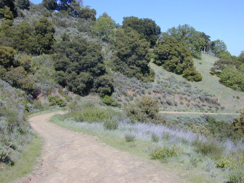
For this featured hike, start at the
Hacienda Trailhead. Walk
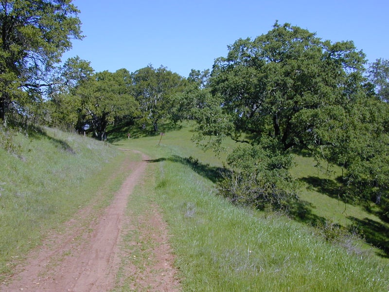
around the gate and uphill on Mine Hill Trail. This trail, a
wide dirt road, was used as a road during years of the mining operations. In
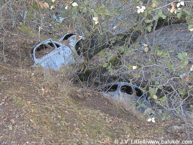
fact, you may notice about 0.85 mile up this trail, two old crashed cars
down the slope on the east (right) side of the trail (click
here for a photo). A few steps up Mine Hill Trail there's
an interpretive display on the left side with some old photos and a history
of the mining operations. A few valley oak mingle with California
bay and big-leaf maple near a creek on the left. The multi-use trail makes
a sharp turn right and climbs at a moderate grade, with coast live oak,
blue oak, poison oak, sagebrush, and coyote brush along the sides. In
spring, you might see bluedicks, filarees, vetch, buttercups, blue and
 white lupine, and fiddlenecks. At 0.4 mile, you'll reach a signed junction,
with Hacienda Trail departing to the right, and English Camp Trail setting
off to the left. Continue straight on Mine Hill Trail.
white lupine, and fiddlenecks. At 0.4 mile, you'll reach a signed junction,
with Hacienda Trail departing to the right, and English Camp Trail setting
off to the left. Continue straight on Mine Hill Trail.
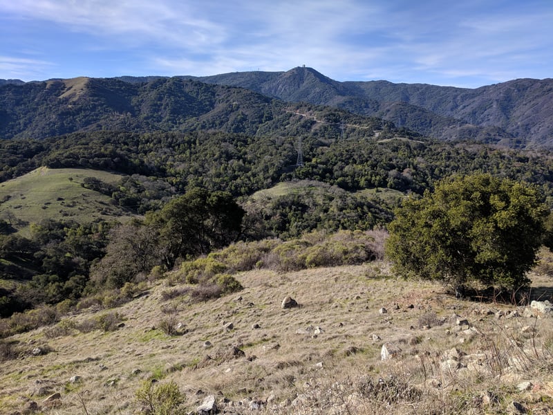
On a clear day the views to the east (Mount Hamilton) and back behind you to the
west (the Sierra Azul) are outstanding, and the stillness of the well-graded
climb through California bay, coast live oak, toyon, California coffeeberry,
chamise, and buckeye is only broken by the buzz of airplanes and bird
cries. A few ravines on the left side of the trail, dry in the summer
and fall, become tiny waterfalls when the winter rains begin in earnest.
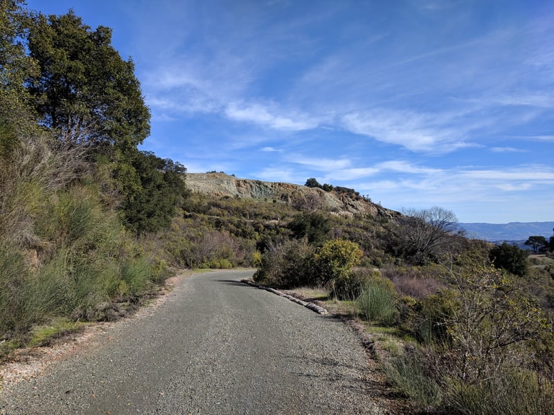
From time to time roadcuts expose sections of dirt and rock, giving mineral
hounds a close-up look at this park's geology. In spring, look for manroot,
shooting stars, monkeyflower, mule-ear sunflowers, woodland star, milkmaids,
and miner's lettuce on the left side of Mine Hill Trail. At 1.15 miles,
after climbing about 300 feet, Mine Hill Trail reaches Capehorn Pass. A
picnic table at this flat spot makes a good place to consult the map,
and drink some water. From this signed junction Hacienda Trail runs north
through chaparral, then cuts east and loops back south to meet up with
Mine Hill Trail. This is a good option if you're ready to turn back
down the hill. You could also continue on Mine Hill Trail, turning
onto Castillero Trail, then picking up English Camp Trail, for a shorter
loop. Turn
right, pass the picnic table, then turn left onto Randol Trail.
To be blunt, this is my least favorite trail
at Almaden Quicksilver. There are pretty sections along the trail, but
thanks to urban sprawl a lot of noise drifts into the park from nearby
housing developments and streets on the northeast side of the mountain.
Nonetheless, Randol is part of a convenient loop, and delivers visitors
to a very scenic part of Almaden Quicksilver. The wide, nearly level multi-use
fire road heads northwest, passing some historical mining sites and drifting
through a variety of plant communities. Initially Randol Trail is lined
with chamise, sagebrush, coyote brush, and coast live oak. Look for zigadene
and saxifrage in early spring here. As the trail sweeps around the broad
mouth of a canyon, there are unobstructed views to gigantic piles of rock
debris on the right. At 1.6 miles, you'll arrive at the site of Day Tunnel.
An interpretive sign explains the origin of the tunnel, which has been
sealed. A few steps later you'll arrive at a signed junction with Day
Tunnel Trail, on the left. Continue straight on
Randol Trail.
 Still keeping to an easy grade, Randol Trail
creeps along the hillside, arching around another broad canyon and mining
site. At 2.1 miles, Randol Trail breaks off to the right, while Santa
Isabel continues straight at a signed junction. Either fork is an option;
Randol is about twice as long. Continue straight on Santa Isabel Trail.
Still keeping to an easy grade, Randol Trail
creeps along the hillside, arching around another broad canyon and mining
site. At 2.1 miles, Randol Trail breaks off to the right, while Santa
Isabel continues straight at a signed junction. Either fork is an option;
Randol is about twice as long. Continue straight on Santa Isabel Trail.
When I hiked here in March, there were great
drifts of baby blue eyes and sprinklings of shooting stars on the left.
Multi-use Santa Isabel Trail ascends slightly through the shade of a California
bay grove, then immediately drops back into coast live oaks, and grassland
marked by a stand of lovely blue oaks. At 2.5 miles, Santa Isabel ends
at the other end of Randol Trail. Bear left onto Randol.
You might see johhny-jump-ups and blue and
white lupine along the trail in spring. California bay, coast live, and
blue oak are common, but Randol Trail also passes through sunnier stretches where coyote brush is dominant.
Gradually, the vegetation shifts to chaparral, and black sage, manzanita,
and chamise makes appearances. After one last pass through some shade,
Randol Trail emerges into grassland. The hillside rolls away on the right,
revealing long views east. At 3.65 miles, you'll reach a signed junction
with Prospect #3 Trail. Turn left.
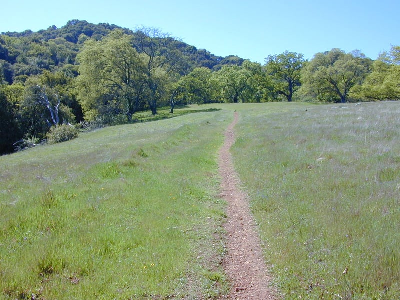
The hiking-only path ascends at a sharp
pace, through grassland dotted with massive black and blue oaks. Wildflowers
bask in the sunshine here, and you might see patches of small flowered
linanthus, johnny-jump-ups, popcorn flower, filaree, and fiddleneck, as
well as smatterings of blue-eyed grass, blue and white lupine, and bluedicks.
The sojourn through oak grassland ends as the trail veers into the woods.
The grade is moderate, with some steep sections, as Prospect #3 Trail
ascends through poison oak, black oak, toyon, and coast live oak. At 4.15
miles, Prospect #3 Trail steps out into grassland, then ends at a signed junction with Mine Hill Trail.
Turn left.
This is a picturesque setting with lots
to admire. In spring there are colorful blasts of blooms in the grassland,
from plants such as California poppy, popcorn flower, blue and white lupine,
johnny-jump-up, and fiddleneck. Graceful oaks beckon from the fringes
of the ridge. And views unfold to the west encompassing the Sierra Azul,
with Mount Umunhum's artificial knob prominent. Mine Hill Trail gently
climbs along the ridge, where trees block views to the east. Coast live
oaks are common along the multi-use trail, but blue oaks, conspicuous
in autumn and spring, can be glimpsed on the sloping hillsides to the
 right. The trail curves left, avoiding a short climb along the ridge by
angling across the hillside, through the shade of California bays. When
Mine Hill Trail leaves the woods,coyote brush lines the trail, nearly obscuring a signed junction, at 4.87
miles, with tiny Catherine Tunnel Trail, on the left. Continue straight.
right. The trail curves left, avoiding a short climb along the ridge by
angling across the hillside, through the shade of California bays. When
Mine Hill Trail leaves the woods,coyote brush lines the trail, nearly obscuring a signed junction, at 4.87
miles, with tiny Catherine Tunnel Trail, on the left. Continue straight.
Mine Hill Trail, here nearly level, reaches
a signed junction with Castillero Trail at about 4.95 miles. The junction,
called Bull Run on the map, is a logical place for a rest stop, with a
few shaded picnic benches on the right. Continue straight, now on Castillero
Trail (Mine Hill Trail, which veers to the left, is an optional route).
Castillero Trail, open to hikers, equestrians,
and cyclists, winds levelly through coast live oak, a few madrone, and
patches of grassland. I happened upon a rattlesnake, stretched across
the trail, on my March 2002 hike. Invasive broom appears on the sides
of the trail, accompanying sagebrush, poison oak, coyote brush, and California
coffeeberry. Castillero Trail crests, then starts an easy descent. Old
mine buildings are visible downslope on the right. The trail curves left
near a tall eucalyptus tree and ramshackle old building. At 5.68 miles,
Hidalgo Cemetery Trail heads out on the right. Continue left, downhill
on Castillero Trail.
The broad trail continues to wind downhill at
an easy grade. At 6.05 miles, you'll reach the edge of English Camp, and
a series of signed junctions. Yellow Kid Tunnel Trail heads doubles back
to the right, toward Hidalgo Cemetery Trail, while Castillero Trail bends
left, on its way to connect with Mine Hill Trail. Continue straight,
to the right of the flagpole, downhill. A few old buildings stand
crumbling on the right, as well as uphill on the left. There are a few
picnic tables nearby, and this is a good place for a last rest before
completing the final leg of the hike. You can explore the area, but
return to the fire road heading southeast, downhill past the picnic tables,
English Camp Trail.
English Camp Trail, open to hikers and equestrians
only, descends. A grassy hillside on the left side of the trail is a sure
bet for spring flowers including blue and white lupine, shooting stars,
redmaids, California buttercups, and fiddlenecks. A few coast live oaks
fail to provide adequate shade on a hot afternoon. At 6.25 miles, a road
sets out on the right side of the trail -- this is Deep Gulch Trail, which is an excellent hot weather alternate
descent back to the trailhead. Continue straight on English Camp
Trail.
English Camp Trail, a bit steep in sections,
drops down to run above a creekbed shaded by California bay and a few
maple, then descends along the edge of a deep canyon, with coyote brush,
toyon, black sage, and manzanita bordering the path. Clematis tangles
itself in trailside shrubs and trees. Unfortunately, this trail follows
a string of power lines down the hill, a less than lovely hiking accompaniment. The
mountains of the Sierra Azul stand in a rugged cluster to the west. There
is one brief but unwelcome uphill stretch. Gradually the vegetation shifts
back to chaparral, grassland and oaks, with bluewitch nightshade, sagebrush,
and monkeyflower accompanying blue and coast live oak. At 7.25 miles,
English Camp Trail ends at a signed junction with Mine Hill Trail. Turn
right and retrace your steps to the trailhead.
Total distance: 7.65 miles
Last hiked: March 28, 2002
Previous visit: January 15, 2001