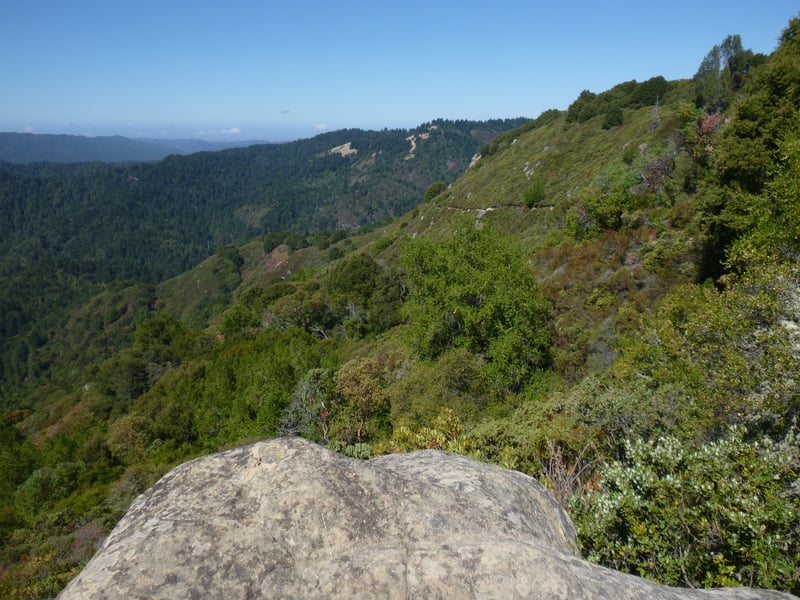
When
I look at a trail map of the Skyline-to-the-Sea route
from Saratoga Gap to the Pacific Ocean, it's hard for me to grasp the
magnitude of that hike: it's 32 miles (one way) and the elevation drops
about 2,600 feet, with lots of ups and downs along the way. From
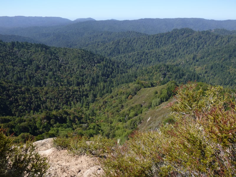
the Saratoga Gap Trail at Castle Rock State Park, the backdrop to this
awesome adventure is laid out at your feet. Although the trail is
not visible, you can see the miles of rolling, forested hills that lie
between Skyline Boulevard and the Pacific Ocean. Castle Rock is unique;
in addition to the park's stunning rock formations and beautiful views,
it's a staging area for long journeys to the sea, or just for great day
hikes lasting a few hours.
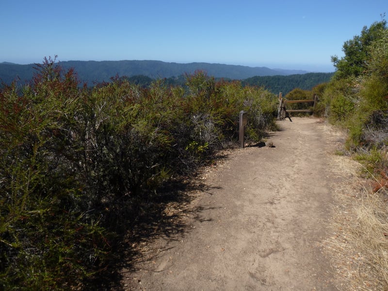
From the Saratoga Gap trailhead, you can take
a short out-and-back hike along CA 9 on Skyline-to-the-Sea Trail, or make a loop
out of Saratoga Toll Road, Travertine Springs Trail, and the Saratoga
Gap Trail, a more than 10 mile trek. For a backpacking excursion, you
can hike from the park's main entrance into Castle Rock Camp, stay overnight,
then continue west into Big Basin State Park. On the opposite extreme,
 the shortest loop at Castle Rock is less than a mile, and combines Castle
Rock and Saratoga Gap Trails.
the shortest loop at Castle Rock is less than a mile, and combines Castle
Rock and Saratoga Gap Trails.
This park is popular with rock climbers,
and can get busy in warm weather. Voices carry far here, and the park
also gets an unwelcome dose of noise pollution from the gun club about
1 mile north of the park entrance on Skyline Boulevard. I prefer visiting
in winter, when the views to the west are clear, and the weather cool. The
gun club is also quieter in the winter, especially if weather is cold
and rainy. Keep in mind that it can get bone-chillingly cold in this part
of the Santa Cruz Mountains, particularly in the heavily forested area
near the main park entrance. Temps in the 20s are not uncommon in
the winter months, and neither is snow. Dress accordingly, and be
careful on the roads, which can get icy.
Castle Rock is not a park I would recommend
to beginning hikers, or those with mobility problems. The trails are narrow,
the drop-offs sharp, and the some of the trails can be slippery. Although
most of the trails are straight-forward, some segments are somewhat technical. It's a tough place for knees and hips, as you must scramble up and down some boulders and navigate steep sandstone shoots. This doesn't mean you shouldn't go if you're in good shape, because the views from
Saratoga Gap and Ridge Trails are worth a few sore joints. A trekking
pole (or two) is definitely recommended.
This featured hike travels through a lovely oak
savannah and chaparral-studded hillsides, under California bay, madrone,
tanoak, and Douglas fir, and past the fascinating sandstone rock formations
known as tafoni. Start from the Robert C. Kirkwood Entrance. Follow signs to the Waterfall Connector Trail, passing through the picnic area. Waterfall Connector Trail winds gently downhill through oaks and madrones, crosses a bridge and ends at a signed junction at 0.3 mile. Turn right onto Saratoga Gap Trail.
Saratoga Gap Trail follows along Kings Creek, and then at a signed
junction meets Ridge Trail at 0.45 mile. Look for wild ginger and giant
chain fern along the creek. Take Ridge Trail, right, uphill.
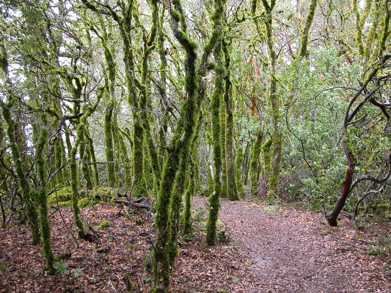
The narrow path ascends,
passing a large, white rock outcrop
and moss-covered live oaks. After only a few moments, the trail leaves
the woods and enters chaparral. Look for chamise, pitcher sage,
varieties of ceanothus, California coffeeberry, manzanitas, and toyon.
In winter, a single flowering
currant puts forth pink blossoms on the right side of the trail at a shady
spot. The views west are breathtaking. Ridge Trail commands your
attention, as tree roots amble across the path like sleeping swollen snakes,
and the trail, smooth and sandy one minute, a pile of boulders the next,
is one surprise after another. On the right side of the trail, a
large outcrop, know as Goat Rock, is visible uphill. Steps are cut
 into some soft rock in one section. At another area, there is a pile of
boulders under the cover of a coast live oak, and the trail is a bit confounding.
"The trail is where?" you may ask, particularly in the winter when leaves
cover the path and foot traffic is limited, making it difficult to see
where others have gone before you. Like a few other confusing trail
sections, if you take it one step at a time the routing
is obvious; it's just impossible to see ahead more than a few feet. The
toughest call is an unmarked junction of sorts, where a legitimate-looking
trail seems to continue on a level course straight ahead, and an unlikely-looking
rock pile heads uphill on the right. Pick your way up the rocky slope,
and the trail becomes evident again. Follow the trail sign, staying to
the right at another confusing non-junction, and continue uphill. Wooden
fencing and steps constructed in 2000 improve the final ascent to Goat
Rock, which previously was a steep, undefined hillside scramble.
At the top of the hill, at 0.8 mile, you'll reach the top of Goat Rock
and two signed junctions (one to the right and one to the left). Bear
left and after a few feet, at another junction, bear right on
Ridge Trail, "to Campground." (Option: at the top of the
steps near Goat Rock, turn right and take the trail marked "to Interpretive Center." The path edges near rocks very popular with climbers, and
then cuts through a grassy oak-studded slope to the Interpretive Center.
Exhibits in the open-air pavilion include a treatise on sandstone formations,
identification drawings of the 7 types of oaks found at Castle Rock, and
a rudimentary trail map. Exit to the north and look for Ridge Trail,
signed "to campground.")
into some soft rock in one section. At another area, there is a pile of
boulders under the cover of a coast live oak, and the trail is a bit confounding.
"The trail is where?" you may ask, particularly in the winter when leaves
cover the path and foot traffic is limited, making it difficult to see
where others have gone before you. Like a few other confusing trail
sections, if you take it one step at a time the routing
is obvious; it's just impossible to see ahead more than a few feet. The
toughest call is an unmarked junction of sorts, where a legitimate-looking
trail seems to continue on a level course straight ahead, and an unlikely-looking
rock pile heads uphill on the right. Pick your way up the rocky slope,
and the trail becomes evident again. Follow the trail sign, staying to
the right at another confusing non-junction, and continue uphill. Wooden
fencing and steps constructed in 2000 improve the final ascent to Goat
Rock, which previously was a steep, undefined hillside scramble.
At the top of the hill, at 0.8 mile, you'll reach the top of Goat Rock
and two signed junctions (one to the right and one to the left). Bear
left and after a few feet, at another junction, bear right on
Ridge Trail, "to Campground." (Option: at the top of the
steps near Goat Rock, turn right and take the trail marked "to Interpretive Center." The path edges near rocks very popular with climbers, and
then cuts through a grassy oak-studded slope to the Interpretive Center.
Exhibits in the open-air pavilion include a treatise on sandstone formations,
identification drawings of the 7 types of oaks found at Castle Rock, and
a rudimentary trail map. Exit to the north and look for Ridge Trail,
signed "to campground.")
Black oaks and California bays mingle with madrones
as the trail winds levelly through grassland. Looks like feral pigs have
invaded the park in a big way, for the ground beneath the oaks was completely
"pig rototiled" on one visit. At 1.0 mile, Ridge Trail
meets the path from the Interpretive Center at a signed junction. Bear
left to stay on Ridge Trail.
This narrow trail cuts through grassland,
gently descending under some live and black oaks, and madrones. Stay
to the right as a faint trail breaks off and heads west, to a bird-watching
viewpoint. I love walking through here in the winter, when it is
quiet and many fallen leaves from
the deciduous oaks litter the trail. As a transplanted easterner,
I delight in the crunch of leaves underfoot, and that smell that defines
autumn for me. At 1.3 miles, you'll reach a signed junction with a connector
 to Saratoga Gap Trail. Continue straight on Ridge Trail, "to campground."
(Option: to shorten this hike, take the trail to the left, signed "to
Saratoga Gap Trail." The connector trail between Ridge Trail
and Saratoga Gap Trail winds downhill; turn left onto Saratoga Gap Trail
at a signed junction and follow the remaining instructions below.)
to Saratoga Gap Trail. Continue straight on Ridge Trail, "to campground."
(Option: to shorten this hike, take the trail to the left, signed "to
Saratoga Gap Trail." The connector trail between Ridge Trail
and Saratoga Gap Trail winds downhill; turn left onto Saratoga Gap Trail
at a signed junction and follow the remaining instructions below.)
The trail continues to lose elevation
at a gradual pace as it descends just downslope from the ridgeline. The trail skirts a rock formation,
where manzanitas seem to be dying out, their sunlight blocked by encroaching
trees. Tanoaks, live oaks, and madrones dominate, but the trail also passes
beneath a small grove of very tall pines. Somewhat abruptly, Ridge Trail
steps out from the trees to a viewpoint at the edge of the ridgeline.
The sheer rocky drop is softened by thick stands of buckbrush, manzanita,
and chamise. Ridge Trail pops back under tree cover, but then draws near
the cliff again, where a wooden fence guards against what would be a nasty
fall. This is my favorite viewpoint, and a nice spot for lunch on a sunny
day. The trail sweeps back into the woods, and continues a descent toward
the campground. At 2.15 miles, Ridge Trail meets Saratoga Gap Trail at
a signed junction. Turn left onto Saratoga Gap Trail.
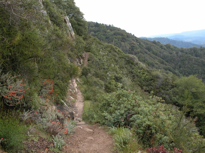
Tanoaks and madrones line the hiking-only trail,
which soon takes a sharp turn left and leaves the forest. Saratoga Gap
Trail narrows as it creeps beneath a rocky outcrop still somewhat shaded
by live oaks and California bays. A metal guidewire helps you navigate a short steep drop over a small boulder. Then the path edges along an exposed hillside, with wonderful views to
distract you from the demanding trail. Manzanitas, ceanothuses, and chamise
dominate, but look for silktassel, lupines, coyote brush, yerba santa,
and monkeyflower as well. There's another tricky section of trail where
you must scramble up and then down a small outcrop. Saratoga Gap
Trail makes a transition into oak grassland, where poison oak is common
in the understory. This area is lovely in autumn, when black oak
trees put on a foliage show. At 3.1 miles, Saratoga Gap Trail meets the
connector path to Ridge Trail at a signed junction. Continue straight
on Saratoga Gap Trail.
A patch of sagebrush flourishes on the left,
and a few buckeyes huddle together in a little gulch on the right. The
trail leaves oak grassland and returns to chaparral. There are nice views
to the rock formations
on the hillside near Goat Rock. Saratoga Gap Trail crosses through a California
bay wood near a stream, where a bench sits just before a narrow bridge.
There's no view from here, but it's nice and shady. Look for a small
 young redwood grove on the right. After crossing the stream the trail
climbs slightly, passing a handful of madrones, which in winter drop curled
strips of bark that look like cinnamon sticks. As the trail crests,
it veers left and edges along the side of the mountain, through chamise,
manzanita, ceanothuses, and aromatic pitcher sage. Saratoga Gap
Trail follows the contour of the slope and features views to the north
and southwest. You may glimpse bobcat and coyote tracks on the trail,
some brief sections of which are steep and awkward to negotiate. Even
before spring reaches Castle Rock, some plants enliven the chaparral with
their blossoms. Manzanitas put forth urn-shaped flowers around
late February, and you might also see blue-witch nightshade and Indian
paintbrush at that time. Buckbrush and wartleaf ceanothus generally bloom
in March. There are a few flat rocks on the west side of the trail, perfect
perches on which to sit and stare out into space. I have one flat
boulder I call my sitting rock. It's a meditative spot, peaceful and serene.
On a December hike I watched two hawks fly so far up in the sky I could
barely follow their movements. I wished I could join them; something
about this view makes me want to fly. On the east side of the trail,
across from my special rock, there's a well-preserved tafoni formation. If
you stop and sit on this rock, or any other, be careful not to fall off
the side of the hill! Saratoga Gap Trail tapers off to a mostly level
grade. Along the trail occasionally a few California bays provide a little
shade. The path squeezes between two boulders, and then begins a return
to a California bay, live oak, Douglas fir, and tanoak forest. On the
left side of the trail two huge old live oaks seem to be
growing out of a patch of moss-covered boulders. You must climb through
a pile of large rocks, a rather illogical stretch of trail which seems
to me could have been routed down the slope a bit. In late winter, look
for the delicate flowers of wild strawberry, nestled close to the ground.
Sounds of rushing water drift down the trail, indicating that you're nearing
the falls. For the best view of Castle Rock Falls, hop down onto
the viewing platform on the right side of the path at 3.9 miles. From
there you'll have a view of the water as it sluices through a rock channel
and then drops 75 feet or so. Even before the storms rage in the
winter, this waterfall is active.
young redwood grove on the right. After crossing the stream the trail
climbs slightly, passing a handful of madrones, which in winter drop curled
strips of bark that look like cinnamon sticks. As the trail crests,
it veers left and edges along the side of the mountain, through chamise,
manzanita, ceanothuses, and aromatic pitcher sage. Saratoga Gap
Trail follows the contour of the slope and features views to the north
and southwest. You may glimpse bobcat and coyote tracks on the trail,
some brief sections of which are steep and awkward to negotiate. Even
before spring reaches Castle Rock, some plants enliven the chaparral with
their blossoms. Manzanitas put forth urn-shaped flowers around
late February, and you might also see blue-witch nightshade and Indian
paintbrush at that time. Buckbrush and wartleaf ceanothus generally bloom
in March. There are a few flat rocks on the west side of the trail, perfect
perches on which to sit and stare out into space. I have one flat
boulder I call my sitting rock. It's a meditative spot, peaceful and serene.
On a December hike I watched two hawks fly so far up in the sky I could
barely follow their movements. I wished I could join them; something
about this view makes me want to fly. On the east side of the trail,
across from my special rock, there's a well-preserved tafoni formation. If
you stop and sit on this rock, or any other, be careful not to fall off
the side of the hill! Saratoga Gap Trail tapers off to a mostly level
grade. Along the trail occasionally a few California bays provide a little
shade. The path squeezes between two boulders, and then begins a return
to a California bay, live oak, Douglas fir, and tanoak forest. On the
left side of the trail two huge old live oaks seem to be
growing out of a patch of moss-covered boulders. You must climb through
a pile of large rocks, a rather illogical stretch of trail which seems
to me could have been routed down the slope a bit. In late winter, look
for the delicate flowers of wild strawberry, nestled close to the ground.
Sounds of rushing water drift down the trail, indicating that you're nearing
the falls. For the best view of Castle Rock Falls, hop down onto
the viewing platform on the right side of the path at 3.9 miles. From
there you'll have a view of the water as it sluices through a rock channel
and then drops 75 feet or so. Even before the storms rage in the
winter, this waterfall is active.
Continue up Saratoga Gap
Trail to the previously encountered junction with the Ridge Trail,
at 4.0 miles. Turn right and retrace your steps uphill on Saratoga Gap Trail and Waterfall Connector Trail. (Option: pass the junction with Waterfall Connector Trail and continue uphill on Saratoga Gap Trail to the signed junction with Castle Rock Trail and turn right. This gently graded path meanders uphill underneath oak, California bay, madrone, and Douglas fir to the tafoni formation
known as Castle Rock. The rock is large and impressive, although unfortunately
the area surrounding it is sometimes defiled with broken bottles, so step
carefully. Castle Rock juts out from a flat spot, like a fairy tale mansion,
and the formation may set your imagination in motion. Weird stone pockets
look like secret caves, and rock cascades off the side like a cresting
wave. When you're done daydreaming, continue on Castle Rock Trail,
pass another group of large boulders off to the right side of the trail,
and then as a fire road continues straight, turn left toward the old parking
lot at a signed junction. Follow the trail back to a fork, and then take
either branch to return to the old parking lot. From here, look for a connector trail near the pit toilet, leading back to the new parking lot.)
Total distance: 4.5 miles (5.3 miles if you
decide to visit Castle Rock)
Last hiked: September 24, 2013
Previous visits: March 5, 2002, February 2, 2001, and December 13, 1999