8.3 mile loop up and down fire roads on the hills above a reservoir where golden eagles are regularly spotted.
Distance, category, and difficulty:
Overall, this 8.3 mile loop hike is moderately tough, with about 2070 feet of elevation change. The trailhead elevation is around 780 feet. This hike climbs to 1600 feet, dips 200 feet, then climbs back to a high point near 1680 feet. After a steep descent to 600 feet, the return leg follows a rolling profile.
Exposure:
Small pockets of shade, but mostly exposed.
Trail traffic:
Light.
Trail surfaces:
Dirt fire roads.
Hiking time:
4-5 hours.
Season:
Early spring is best.
Getting there:
From Interstate 580 in Alameda County, exit Vasco Road (exit 55). Drive north about 5 miles, then turn left onto Los Vaqueros Road (look for small brown signs) and continue to the parking lot. Access the north side of the watershed from Camino Diablo (turn onto Walnut Boulevard).
GPS Coordinates* for Trailhead:
Latitude
Longitude
(* based on Google Earth data, shown as degrees, minutes, seconds)
Gas, food, and lodging:
Stores, restaurants, and gas back near 580. No camping.
Trailhead details:
Good size dirt parking lot. $6 entry fee charged ($4 you live in a town serviced by the water district) If entry kiosk is unstaffed, use self-registration box in parking lot. Maps available from entry kiosk or at the information signboard in the parking lot. Restroom on site. There is no direct public transportation to the watershed.
Rules:
Most trails are designated hiking only. Some are multi-use (this is unusual in the bay area). No dogs. Watershed is open from 7 a.m. to 5 p.m. (later in summer).
The Official Story:
CCWD's Los Vaqueros page.
Watershed info 925-371-2628 or 925-240-2360
Map/Book Choices:
•
• Bay Area Trail Map: Mount Diablo, published by Redwood Hikes, is a fantastic guide to Los Vaqueros and surrounding parklands.
• Map from CCWD (download the pdf)
My
continuing search for outdoor solitude in
the bay area led me to Los Vaqueros Watershed in Contra Costa County,
and what I found (and failed to find) there will bring me back again.
Miles and miles of soft rolling grassland hills, oak and chaparral studded
slopes, and a beautiful blue reservoir comprise this watershed managed
by the Contra Costa Water District. The Los Vaqueros Project was completed
in 1998; the reservoir is so new that it does not appear on all but the
most recent maps. The Water District is planning more trails, and an interpretive
center, marina, and group picnic area opened in 2001. All the multi-use
trails are in the north end of the watershed (accessible from the Walnut
and Dam Staging Areas), while all the trails near the County Line Staging
Area are open to hikers only. Experienced hikers can even trek into Morgan
Territory Regional Preserve (onto Volvon Trail via Black Hills Trail,
or onto Manzanita Trail via Miwok Trail) and and
via Miwok Trail), creating the possibility of extended hiking adventures.
 Trails have been ranked for difficulty by the Water District, so be sure
to take those designations to heart while planning a hike; since their
map has no topography, it's easy to get in over your head on trails
that all seem to be old fire or ranch roads, better suited to four-wheel
drives than legs.
Trails have been ranked for difficulty by the Water District, so be sure
to take those designations to heart while planning a hike; since their
map has no topography, it's easy to get in over your head on trails
that all seem to be old fire or ranch roads, better suited to four-wheel
drives than legs.
For the featured hike, start at the
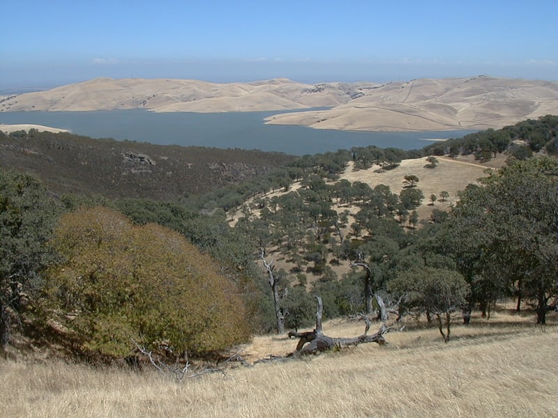
County Line Staging Area. When I visited on a July morning, a golden eagle
soared on the hillside across from the entry kiosk (it's a barely visible
speck in the top photo on this page). Begin by walking to the west
on the signed Black Hills Trail. Walk through and close the cow gate,
then begin a moderate climb on the wide dirt trail. After just about 0.1
mile, Los Vaqueros Trail begins to the right at a signed junction.
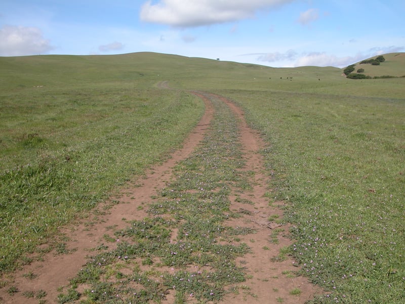
Continue uphill on Black Hills Trail. The grassland is punctuated
by yellow star thistle (a common sight at the watershed), but little else,
at least in the summer. As you climb, views begin to open up, and the low hum of the
nearby windmills (you're not far from Altamont here) drifts across the
valley. At about 0.7 mile, Valley View Trail sets out at a signed junction
on the left side of the trail. (You can shave off some mileage by continuing
straight here.) Turn left on Valley View Trail.
Valley View initially runs south, then sweeps
to the right near the watershed's border and starts a climb. To the west
a pretty valley cradles some increasingly rare Contra Costa County farmland.
The broad trail rises and then falls a couple of times, all the while
affording fantastic views of the northern section of the watershed and
the reservoir. Finally Valley View Trail makes a turn to the right and
begins a short descent. A fire road heads away from the watershed
at an undersigned junction at 2.6 miles. Stay to the right. The
trail levelly heads east, then ends at a signed junction with Black Hills
Trail at 2.7 miles. Turn left on Black Hills Trail.
With the grassland bleached blonde in the
summer, the hills ahead of you look like corn muffins studded with raisins.
At 2.8 miles, Homestead Trail begins on the right side of the trail at
a signed junction. (You can shorten this hike by taking Homestead to Los
Vaqueros and then returning to the trailhead. This is the last opportunity
 to create a shorter hike.) Continue straight on Black Hills Trail.
A short climb brings you to a rocky and oaky hilltop. On a windy day it's
almost too breezy to stop here, but the views are nice. After a brief
level stretch, Black Hills Trail leaves the oaks (and rocks) behind and
starts a mild descent. Ignore an unmarked path that leads to a gate on
the right side of the trail. The wide dirt road edges along the watershed's
boundary. Morgan Territory Road is visible to the west. The grade is mostly flat, but then
Black Hills Trail passes a road leading out of the park on the left and
dips downhill near a dead tree. The descent is over before you know it
and the trail starts climbing along a pretty gulch, through more uninterrupted
grassland. The trail reaches a flat spot, then switches to the west side
of the hill, towering above a lovely valley on the left. In a watershed
with a lot of lonely places, this has to be one of the quietest. Neither
the reservoir nor outside roads are visible, or audible. At 4.3 miles,
Black Hills Trail takes a sharp dive to the west as Cañada Trail
begins at a signed junction. (Black Hills Trail heads toward Morgan Territory,
and the hiking becomes more challenging on the trail after this junction.)
Continue straight on Cañada Trail.
to create a shorter hike.) Continue straight on Black Hills Trail.
A short climb brings you to a rocky and oaky hilltop. On a windy day it's
almost too breezy to stop here, but the views are nice. After a brief
level stretch, Black Hills Trail leaves the oaks (and rocks) behind and
starts a mild descent. Ignore an unmarked path that leads to a gate on
the right side of the trail. The wide dirt road edges along the watershed's
boundary. Morgan Territory Road is visible to the west. The grade is mostly flat, but then
Black Hills Trail passes a road leading out of the park on the left and
dips downhill near a dead tree. The descent is over before you know it
and the trail starts climbing along a pretty gulch, through more uninterrupted
grassland. The trail reaches a flat spot, then switches to the west side
of the hill, towering above a lovely valley on the left. In a watershed
with a lot of lonely places, this has to be one of the quietest. Neither
the reservoir nor outside roads are visible, or audible. At 4.3 miles,
Black Hills Trail takes a sharp dive to the west as Cañada Trail
begins at a signed junction. (Black Hills Trail heads toward Morgan Territory,
and the hiking becomes more challenging on the trail after this junction.)
Continue straight on Cañada Trail.
The trail begins to descend. Some huge boulders
stand watch at the top of the hill to the right. The views to the north
and east are spectacular. The reservoir shines like a gem in the valley,
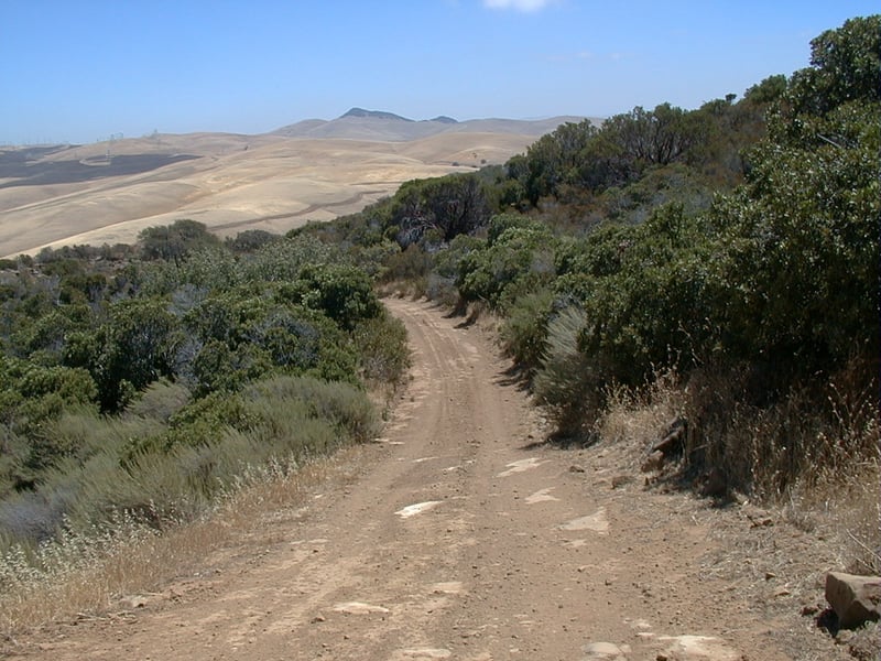
while to the north the rock and oak covered hills create a rugged profile. Cañada
Trail sweeps to the right and cuts through some buckeyes and oaks (mostly
blue), then turns to the left and angles along a chaparral-covered hillside.
California sagebrush and monkeyflower accompany black sage and toyon.
Large manzanitas appear, and then yerba santa and chamise, which assumes
a reddish tinge in the summer. The grade is occasionally steep and rocky.
As you descend, oaks muscle into the chaparral territory. At 6.1 miles,
Cañada Trail ends at a signed junction with Los Vaqueros Trail,
close to the southern edge of the reservoir. Turn right onto Los Vaqueros
Trail.
Although the trail runs along the level
Los Vaqueros Road, it is a roller coaster. More than once I looked longingly
at the pavement, but decided to stick it out on the wide trail. As you
trudge up and down through the oaks, look for hawks and golden eagles
in the skies and trees to the east. At 7.9 miles, you pass the other end
of Homestead Trail at a signed junction. Continue straight. One
last easy climb brings you to the previously encountered junction with
Black Hills Trail, at 8.2 miles. Turn left and return to the trailhead.
Total distance: about 8.3 miles
Last hiked: Monday, July 17, 2000