4.9 mile loop at a remote oak and grassland preserve.
Distance, category, and difficulty:
This 4.9 mile loop hike is moderately easy, with the exception of steep Coyote Trail. Elevation at the trailhead is around 2040 feet. The lowest elevation in the park is around 1100 feet, and highest elevation is around 2300 feet. Total elevation change for this hike is about 1040 feet. There is somewhat significant elevation change in the park. Short hikes under 5 miles should present no problems for hikers in moderate condition. Longer hikes can be planned with minimal elevation change, but keep in mind that hiking at Morgan Territory is much more difficult in hot weather.
Exposure:
Mostly exposed until the last mile.
Trail traffic:
Light.
Trail surfaces:
Dirt fire roads and trails.
Hiking time:
3 hours.
Season:
Spring, spring, spring!
Getting there:
• From Interstate 580 in Alameda County, exit North Livermore Avenue (exit 52b). Drive north on North Livermore. After the road makes a sharp left, it becomes Manning. Shortly after, turn right onto Morgan Territory Road (at this point you'll have driven about 4 miles from 580). Drive about 5.5 miles on narrow, winding, one-lane Morgan Territory Road, to the signed park entrance on the right side of the road.
• From the CA 24/Interstate 680 interchange in Contra Costa County, exit Ygnacio Valley Road (exit 46b). Drive east on Ygnacio Valley Road about 8 miles, then turn south onto Clayton Road. Clayton Road turns into Marsh Creek Road in Clayton. Continue south on Marsh Creek Road, then turn right onto Morgan Territory Road. Drive about 9 miles (on this narrow road) to the park entrance on the left side of the road.
• If you want to explore the western section of the park, from Interstate 580, exit Tassajara (exit 47). Drive north on Camino Tassajara, and turn right onto Finley Road. There is roadside parking at the end of Finley Road.
GPS Coordinates* for Trailhead:
Latitude
Longitude
(* based on Google Earth data, shown as degrees, minutes, seconds)
Gas, food, and lodging:
Gas, stores, and restaurants back on Livermore Avenue, south of 580. No camping.
Trailhead details:
No parking or entrance fees. Large gravel lot. Two pit toilets. Drinking water at trailhead. No designated handicapped parking, and trails are not wheelchair accessible. Emergency phone in parking lot. Maps at information signboard. There is no direct public transportation to the preserve.
Rules:
Most trails are multi-use. A few are designated hiking only. Dogs rules here. Preserve is open from 8 a.m. to (hours shift seasonally) 5-9 p.m.
The Official Story:
EBRPD's Morgan Territory page
Park headquarters (in Antioch) 925-757-2620
Map/Book Choices:
• Map from EBRPD
• Bay Area Trail Map: Mount Diablo, published by Redwood Hikes, is a fantastic guide to Morgan Territory and surrounding parklands.
• Malcolm Margolin's East Bay Out has a simple map and lyrical preserve descriptions (order this book from Amazon.com).
Morgan Territory in a nutshell -- a printable, text-only guide to the featured hike.
Go to Bay Area Hiker Home page
The
words remote and lonely are often uttered by hikers after
a day on the trails at Morgan Territory. Although smaller in acreage than
EBRPD's Chabot, Black Diamond Mines, or Briones, Morgan Territory feels
more expansive than any of those parks. And with trail connections to
Round Valley, Los
Vaqueros, and Mount Diablo, Morgan
Territory has become the hub of a rugged eastern Contra Costa County greenbelt.
A desolate feeling sets in almost as soon
as you exit Interstate 580. North Livermore Avenue cuts through flat fields
and ranch land, and then single lane Morgan Territory Road heads up into
the hills. After a few white knuckle miles, you'll arrive at the sparse
parking lot. Most people do not show up at Morgan Territory for picnics
or birthday parties, or stumble onto the trailhead; hikers, equestrians,
and cyclists make the pilgrimage to this preserve for serious outdoor
excursions. Wildflower enthusiasts flock to Morgan Territory in March,
 April, and May, when many plants unfurl and bloom with furious intensity.
Grassy hillsides and valleys are taken over in
a harlequin display of johnnytuck, California buttercup, goldenfields,
popcorn flowers, broadleaf filaree, woodland star, fiddleneck, and bludicks.
Tucked away in the woods you might glimpse larkspur and chinese houses.
As spring fades into summer, temperatures soar at Morgan Territory. If
you visit in warm months, carry plenty of water and consider shorter treks.
High temps often persist into autumn, which has its own charms. Morgan
Territory's oaks and maples provide a foliage show prior to winter, when
the manzanitas do their part, filling the breezes on crisp cool days with
the scent of their blossoms. Winter rains contribute to muddy conditions
in this cow-grazed park. Then spring rolls around and the whole cycle
begins again. Unless you're visiting Morgan Territory on a hot day, bring a
jacket. The temperature in the park is usually lower than the surrounding
areas, and winds drop the temperature even lower.
April, and May, when many plants unfurl and bloom with furious intensity.
Grassy hillsides and valleys are taken over in
a harlequin display of johnnytuck, California buttercup, goldenfields,
popcorn flowers, broadleaf filaree, woodland star, fiddleneck, and bludicks.
Tucked away in the woods you might glimpse larkspur and chinese houses.
As spring fades into summer, temperatures soar at Morgan Territory. If
you visit in warm months, carry plenty of water and consider shorter treks.
High temps often persist into autumn, which has its own charms. Morgan
Territory's oaks and maples provide a foliage show prior to winter, when
the manzanitas do their part, filling the breezes on crisp cool days with
the scent of their blossoms. Winter rains contribute to muddy conditions
in this cow-grazed park. Then spring rolls around and the whole cycle
begins again. Unless you're visiting Morgan Territory on a hot day, bring a
jacket. The temperature in the park is usually lower than the surrounding
areas, and winds drop the temperature even lower.
For the featured hike, begin at the
information signboard. Start hiking on multi-use Volvon Trail.
After about 170 feet, Coyote Trail sets out on the left at a signed junction.
Bear right on Volvon. In spring, you might see carpets of johnnytuck
and California buttercups on the right side of the trail. The wide trail
crests at 0.12 mile, and meets the other leg of Volvon. Bear left.
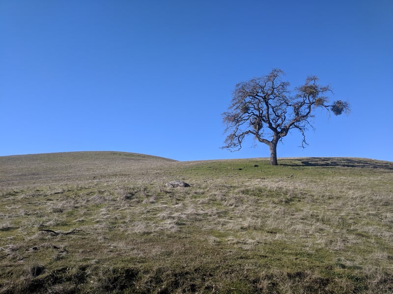
Volvon Trail is lined with coast live oaks.
A few California bays, deciduous oaks, and buckeyes are also present.
Ignore any shortcuts and paths that break off from Volvon, as the wide
trail descends gently through grassland and trees. At 0.3 mile, Volvon
joins a broad trail heading north from the park boundary. Bear left
to remain on Volvon.
The trail travels the length of a small
valley,then
emerges into another grassy diminutive bowl between the hills. Along the
sides of the trail you might see fiddlenecks, woodland star, bluedicks,
filaree, and johnnytuck in spring. A look to the left reveals Mount Diablo's
profile. At 0.6 mile, Volvon Trail meets Whipsnake Trail at a signed
junction. Turn left to remain in Volvon. Just a few steps
later, at 0.7 mile. Volvon Trail meets Blue Oak Trail at a signed junction.
 Bear right onto Blue Oak Trail.
Blue Oak Trail, open to cyclists, equestrians,
and hikers, passes a pretty coast live oak, then a few fruit and walnut
trees, before undertaking a brief climb. In early spring there are substantial
swaths of popcorn flowers and filaree on the right. Drifting easily downhill,
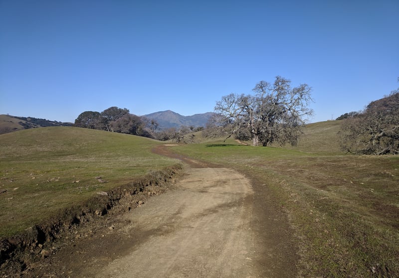
Blue Oak Trail permits more nice views of Mount Diablo's peaks. Blue and
valley oaks dot the grassland. At 1.3 miles, Blue Oak
Trail reaches a signed junction with Miwok Trail. Bear left to remain
on Blue Oak Trail.
Sweeping west, the trail is nearly level.
A rough path breaks off the trail on the left. This is not Hummingbird
Trail, which is a little further down the trail, at 1.4 miles. When you
reach the signed junction with Hummingbird, if you're ready to
cut your hike short, you can turn left there and return to the
trailhead via Volvon and Condor Trails. If you're up for the longer
hike, bear right to remain on Blue Oak Trail.
Blue Oak Trail climbs a hill, then resumes
an easy grade. Oaks and buckeyes crowd the trail. This is a very quiet
part of the preserve. On my early spring hike, woodland star was the dominant
bloom along the trail. At 2 miles, Blue Oak Trail ends at a
signed junction with Volvon Trail. (This junction provides the last opportunity to shorten the hike. If you're ready to turn back, take Volvon to the
left, back to the trailhead.) Turn right on Volvon Trail.
A slight descent on Volvon Trail will bring
you to a pit toilet, cattle gate, and signed junction at about 2.1 miles.
Valley View Trail heads off to the right. Continue straight on Volvon.
After a short climb through oaks and grassland,
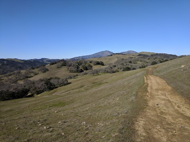
Volvon reaches a signed junction at a notch in the hills, at 2.4 miles.
To the right, Volvon sets of on a circuit around Bob Walker Ridge; this is an option to
extend your hike. Long views of Mount Diablo unfold to the north. The
hills of Los Vaqueros are partially visible to the east. Your future route
rambles downhill into a valley. This notch is a great place for lunch,
unless it's a cool day. The breezes that will dry your sweat on a hot
day, are not so welcome when it's chilly. Bear left and descend on Volvon Trail.
Volvon begins a descent. The trail is lumpy
 from cow travel. You might see California poppies, bluedicks, and fiddlenecks
in the grass during spring. At 2.7 miles, Volvon Trail meets Stone Corral
Trail at a signed junction. Turn left.
from cow travel. You might see California poppies, bluedicks, and fiddlenecks
in the grass during spring. At 2.7 miles, Volvon Trail meets Stone Corral
Trail at a signed junction. Turn left.
Rocks hunker down beneath oaks on the right
side of the trail. Multi-use Stone Corral Trail descends, in sections
rather sharply, toward the valley floor. This was the only area of the
preserve where I encountered cows. You'll pass through a cattle gate,
and then ignoring a path on the left along a creekbed, reach a signed
junction with Coyote Trail at 3.3 miles. Turn left on Coyote Trail,
a hiking only path.
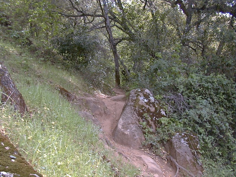
Coyote Trail begins by following the contour
of a grassy hillside, but soon drops down to a cattle gate at the edge
of woods.The
trail splits, but the two legs soon rejoin and then climb easily along
a seasonal creek. California bay, buckeye, coast live and black oak, and big-leaf
maple provide a canopy. In the understory you might see honeysuckle, toyon,
coffeeberry, snowberry, and lots of poison oak. Narrow Coyote Trail hops
across the creekbed, then reaches a grassy section where manzanitas
are sprinkled under the trees on the left side of the trail. At 4.1 miles,
hiking-only Mollok Trail begins on the right side of the trail at a signed
junction. Continue straight on Coyote Trail.
You'll finally work to regain all of the
hike's lost elevation on this stretch of trail. Coyote Trail climbs, occasionally
very steeply, along the creekbed. Creambush and poison oak are common. In
spring, look for shooting stars and blue larkspur. The trail crosses a
feeder creek near a pile of large boulders, and keeps on climbing. A rough
path breaks off to the left at the top of one steep pitch. Look left there
for a view of a high rocky reef to the east. Then look back over your shoulder for a glimpse
of Diablo, and the vista out of the canyon. On my hike in April there
were scads of Chinese houses and blue larkspur on the left side of the
trail. Then it's back to the ascent, which remains mostly wooded, although
you'll pass a few more manzanitas and some grassy patches. Coyote Trail
eventually reaches the creekbed. Trails seem to take off in every direction
here, but you want to cross the creek, then head uphill on the right side
of the creekbed. Huge rock boulders perch on both side of the trail and
creek. Some have grinding bowls worn into them, testament to Morgan Territory's
first residents, the Volvons. At the crest of the hill, Coyote Trail steps
out of the woods. A few feet further, you'll veer left and skirt the banks
of a pond, then drop down to a signed junction with Condor Trail at 4.8
miles. Bear right on Coyote Trail.
The trail cuts through a meadow, and meets
a previously encountered junction at 4.9 miles. Turn right and retrace
your steps to the trailhead, which is visible from the junction.
Total distance: 4.9 miles
Last hiked: Monday, April 2, 2001