Have
you ever been to a ghost town? How about
a ghost preserve? There's something about Round Valley, maybe it's
the deep quiet, or the emptiness, or the abandoned farm equipment...
whatever it is, this is a lonely preserve that makes for quiet contemplation,
especially on weekdays.
Once home to California Native Americans, the land was
farmed and ranched since the late 1800's, and a few pieces of historic
farm equipment (look but don't touch) dot the landscape of this Diablo
foothills preserve. Round Valley was sold to the East Bay Regional Park
District in 1988.
It gets super hot here in the summer, so
you may want to visit on a cool fall morning, when raptors are active,
 or in the early spring, for wildflowers in the valley (although the cows
eat most of them). From the first storm to the end of the rainy season, Round Valley trails are muddy.
or in the early spring, for wildflowers in the valley (although the cows
eat most of them). From the first storm to the end of the rainy season, Round Valley trails are muddy.
There is now a connector trail, crossing Round Valley
Creek, that permits a second loop here.
Many visitors are drawn to the preserve
for birdwatching, and in particular, raptor observation. On my first Round
Valley hike I observed a golden eagle hunting above the hillside and then
sitting on top of a tree. Redtail hawks are common, and on another visit
I saw a redtail flying while clutching a squirrel. If you're quiet and
lucky you may see bobcats and coyotes, but you definitely will see scads
of squirrels, often feasting on acorns from the preserve's many oaks. These squirrels are fat and sassy, and when you disturb them they take off across the trail to their burrows as if chased by a missile. Round Valley is also protected habitat for the San Joaquin kit fox, and because these small mammals live
here, no dogs are allowed in the preserve. With the opening of the Los
Vaqueros Watershed, Round Valley has become a hiker-friendly trailhead
for long all day excursions to parks south and west of the preserve. Starting
at Round Valley saves you the Los Vaqueros entrance fee, and there is
plenty of parking. It's about 2.5 miles to the Los Vaqueros entrance,
and then 1.6 more miles to Morgan Territory.
You can't loop back to Round Valley, but if you hike with a friend you
can create good one-way shuttle hikes by leaving a car at Morgan Territory.
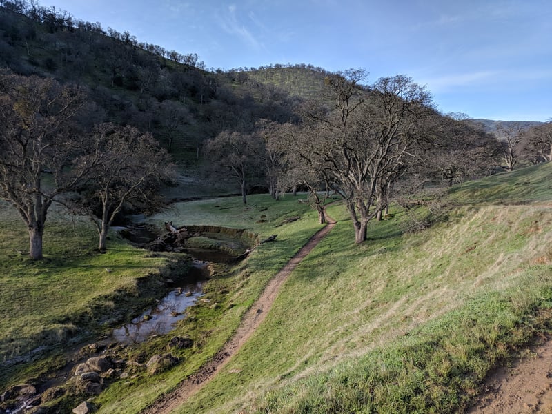
Start from the trailhead at the
southern end of the parking lot. A short connector path leads
to a sycamore and walnut-shaded bridge. At the other end of the
bridge, at 0.10 mile, signed Hardy Canyon Trail begins on the left (you
can take this loop in either direction). Continue through the cattle
gate and straight, on Miwok Trail.
The broad multi-use fire road begins a
climb through blue oak woodland. On a winter hike I watch a small flock of white-brested nuthatches flit from tree to tree. Much of the rock in this area is sandstone,
 so the trail surface is very soft in some areas, and the trail itself
can be dusty or muddy -- frequent equestrian use and the preserve's range
cattle contribute to bad trail conditions in wet weather. The trail
crests, drops back down and then heads up again. At the start of the second ascent, at 0.31 mile, continue straight on a small, but established unsigned trail that runs along the fence and rejoins the main
trail at the foot of the hill. The shortcut rejoins the fire
road at 0.39 mile. You'll cross one of several creekbeds that crease the
hillside to your left. At a signed junction at 0.49 mile an access road
sets out to the right and then enters private property; stay to the
left on Miwok Trail.
so the trail surface is very soft in some areas, and the trail itself
can be dusty or muddy -- frequent equestrian use and the preserve's range
cattle contribute to bad trail conditions in wet weather. The trail
crests, drops back down and then heads up again. At the start of the second ascent, at 0.31 mile, continue straight on a small, but established unsigned trail that runs along the fence and rejoins the main
trail at the foot of the hill. The shortcut rejoins the fire
road at 0.39 mile. You'll cross one of several creekbeds that crease the
hillside to your left. At a signed junction at 0.49 mile an access road
sets out to the right and then enters private property; stay to the
left on Miwok Trail.
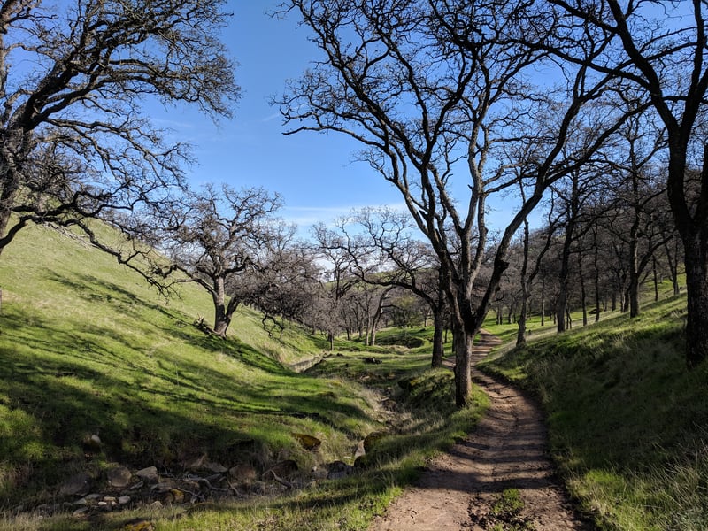
Miwok climbs slightly along the creekbed, where
some water remains all year long. Look for frogs, including the California
red-legged frog (federally threatened), bathing in the shallow pools,
and turtles sunning themselves on rocks. Buckeyes huddle in the canyons
to the left; some of the deciduous trees creep out to the trail, keeping
the blue oaks company. A few California sagebrush shrubs grow along the creek. The hillside to
the north is folded in corduroy rows, mostly bare of trees, and topped
with a line of oaks. I've seen golden eagles in this part of the
preserve. Take note of the interesting sandstone formations in the creekbed,
and across the creek on the side of the hill: there are similar sandstone
rock sculptures and corduroy hills at Las Trampas
Regional Wilderness preserve, about 20 miles west of Round Valley.
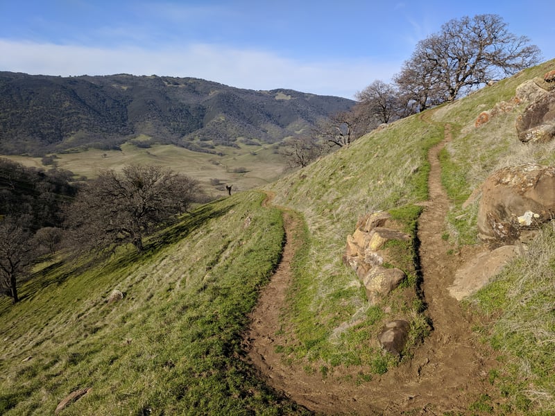
At 1.3 miles, the trail curls south around the base of a hill, opening
up into Round Valley. Hardy Canyon Trail begins at a signed junction
on the left. (If you want to explore the valley before continuing on the
loop, keep going straight on Miwok Trail: the trail remains
almost totally flat as it follows the creek. When you're ready, return to this
junction.) Turn left onto Hardy Canyon Trail.
 The narrow trail, open to hikers and equestrians,
leaves the valley floor and begins to climb at a moderate grade. Blue
oaks and grassland continue to dominate the landscape, although buckeyes
are common in the hillside's creases. On the right, a sloping hillside
of grass gives way to the flat valley, then oak-studded hills to the west. In
autumn the grass is honey-colored, but by late winter everything is green,
and some yellow California buttercups and orange fiddlenecks evade the
hungry cows, blooming most abundantly near the creekbeds and draws along
the trail. It's a steady ascent, not hard but with no respite either.
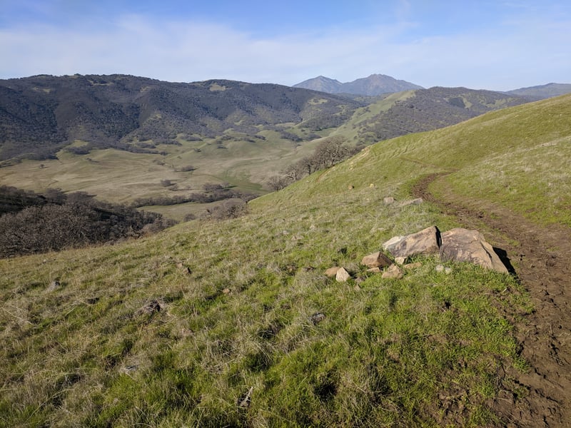
Be sure to pause now and then for a look back to the north, as Mount Diablo's
two peaks are increasingly revealed. On a November hike, prints from coyote, fox, and bobcat were clearly visible on the damp trail surface. At 2 miles, the trail reaches a rock outcrop, then ascends via two
switchbacks and passes over the top of the formation. There's a stretch
of pure grassland, and the trail crests at 2.3 miles. Round Valley's
highest hill sits just off to the left (off limits to humans). Without much of a pause, Hardy Canyon Trail heads downhill
through grassland. A path heads left toward a watering trough; stay to
the right here. The descent is steady. There's a little dip near a slide
area, then Hardy Canyon Trail adopts a course along a creekbed. Buckeye
are common, and you might see a few toyon, California bay, and coast live
oak, but this is prime blue oak territory. The trail continues a modest
descent, with a very short easy uphill section. You might notice an old
small earth dam, where water pools during the rainy season. At 3.6 miles, a
path continues straight, while Hardy Canyon Trail veers left, crossing
the creek -- you'll get your feet wet here in winter and early spring.
After a brief climb, the trail levels out and angles across a hillside.
Traffic noise from Marsh Creek Road is audible. You might see hawks soaring
above a grassy meadow on the right. The trail curves across grassland,
and a rough trail feeds in from the right before a cattle gate. Now along the shore of Marsh Creek, valley oak, cottonwood,
sycamore, buckeye, and willow are common. The grade is level until the
last few feet, when it rises up to meet Miwok Trail and the bridge, at
4.3 miles. Turn right and retrace your steps back to the trailhead.
The narrow trail, open to hikers and equestrians,
leaves the valley floor and begins to climb at a moderate grade. Blue
oaks and grassland continue to dominate the landscape, although buckeyes
are common in the hillside's creases. On the right, a sloping hillside
of grass gives way to the flat valley, then oak-studded hills to the west. In
autumn the grass is honey-colored, but by late winter everything is green,
and some yellow California buttercups and orange fiddlenecks evade the
hungry cows, blooming most abundantly near the creekbeds and draws along
the trail. It's a steady ascent, not hard but with no respite either.
Be sure to pause now and then for a look back to the north, as Mount Diablo's
two peaks are increasingly revealed. On a November hike, prints from coyote, fox, and bobcat were clearly visible on the damp trail surface. At 2 miles, the trail reaches a rock outcrop, then ascends via two
switchbacks and passes over the top of the formation. There's a stretch
of pure grassland, and the trail crests at 2.3 miles. Round Valley's
highest hill sits just off to the left (off limits to humans). Without much of a pause, Hardy Canyon Trail heads downhill
through grassland. A path heads left toward a watering trough; stay to
the right here. The descent is steady. There's a little dip near a slide
area, then Hardy Canyon Trail adopts a course along a creekbed. Buckeye
are common, and you might see a few toyon, California bay, and coast live
oak, but this is prime blue oak territory. The trail continues a modest
descent, with a very short easy uphill section. You might notice an old
small earth dam, where water pools during the rainy season. At 3.6 miles, a
path continues straight, while Hardy Canyon Trail veers left, crossing
the creek -- you'll get your feet wet here in winter and early spring.
After a brief climb, the trail levels out and angles across a hillside.
Traffic noise from Marsh Creek Road is audible. You might see hawks soaring
above a grassy meadow on the right. The trail curves across grassland,
and a rough trail feeds in from the right before a cattle gate. Now along the shore of Marsh Creek, valley oak, cottonwood,
sycamore, buckeye, and willow are common. The grade is level until the
last few feet, when it rises up to meet Miwok Trail and the bridge, at
4.3 miles. Turn right and retrace your steps back to the trailhead.
Total distance: 4.40 miles
Last hiked: February 7, 2019
Previous visits: November 14, 2002 and October 4, 1999