Calero
County Park is a treasure for hikers seeking solitude, especially
from cyclists and dog walkers. The park is open only to equestrians and
hikers, a rarity in the south bay. While there is a stable on the park's
grounds, I encountered only one equestrian (and one other hiker) on a
weekday visit. The trails obviously get more equestrian use on the weekends,
and in the winter muddy, rutted trails are a reality. But on a weekday
in the dry months, the lonely trails provides ample quiet time for nature
study and daydreaming, particularly in the spring, when the park's grasslands
are dotted with wildflowers. With a field guide in hand a curious hiker
can spend the whole day at Calero identifying and admiring the splendid
displays of blooming flowers.
The park's trails sprawl on the south side
of the Calero Reservoir. Since the boat launch is on the north side of
the reservoir, the southern shore is mostly free of boaters and fishermen,
although the kind of garbage prone to reservoir usage may be found sprinkled around the water's edge at times.
There are a few loop options available.
A 2.6 mile stretch includes Figueroa, Vallecito, Peña, and
Los Cerritos Trails. This hike does not approach the reservoir's shores
at all, instead climbing along a creek to a ridgeline with great views
of Mount Hamilton, and finally descending around the edge of lovely small
 pond. The grand loop at Calero is a 7.5 mile trek that explores the different
regions of the park. Combine Los Cerritos, Peña, the Javelina Loop,
and Figueroa Trails, and prepare for an inspiring, sometimes steep hike.
If you're short on time or energy, Los Cerritos Pond is a short round
trip of less than 0.5 mile from the trailhead.
pond. The grand loop at Calero is a 7.5 mile trek that explores the different
regions of the park. Combine Los Cerritos, Peña, the Javelina Loop,
and Figueroa Trails, and prepare for an inspiring, sometimes steep hike.
If you're short on time or energy, Los Cerritos Pond is a short round
trip of less than 0.5 mile from the trailhead.
For the featured hike, cross the street
from the trailhead and go through the gate which marks the start of
the trail. Walk on this short connector which edges around a fenced horse-grazing area, passes an information signboard, then ends at the signed
junction of Oak Cove and Figueroa trails, at 0.2 mile. In the damp
seep downhill from Los Cerritos Pond, spring flowers, including the yellow/orange
fiddlenecks flourish. Curly dock is another prominent water-loving plant
found along the sides of the trail. It's tough to miss in the late summer,
when its reddish-colored seed pods jut up from the leaves. The seeds are
devoured by deer, fox, and coyote, and evident in their scat. Take
Oak Cove Trail uphill to the right.
The dirt path winds along the shore of
Los Cerritos Pond. A wood deck beneath an oak tree makes for a fine
resting spot, or destination. The hilltops to the southwest are
thick with trees, but Oak Cove Trail, which initially stays close
to the reservoir, cuts mostly through open grassland. In the spring, deciduous
oaks are easy to pick out, as their soft green leaves are just pushing
out of their buds. Buckeyes are already fully engulfed in fresh foliage
by late winter. Oak Cove Trail crests just past the pond, then drops
back down and crosses a creek. After a short climb, at 0.6 miles, Oak Cove Trail meets Peña Trail at
a signed junction. Continue to the right on Oak Cove Trail.
Oak Cove Trail cuts a straight path
through the grass. Yellow California buttercups, white wild radish,
pink checker-blooms, and orange johnny jump-ups dotted the hillside on
a hike in March. The path curves to the right and nears the Calero Ranch
Stables. On the first day of spring I watched a horse rolling on her back
in a sandy spot, like a happy dog. A large stand of mustard grows off
the side of the trail. Stay to the left on Oak Cove Trail,
and note that, although the stables would make a fine shortcut back to
the trailhead, access is for boarding equestrians only. As the
trail climbs slightly, you may see ground squirrels scurrying about, trying
to evade the many hawks soaring around the reservoir. Oak Cove Trail
crests, then descends gently toward the water. The Bailey Fellows House
is visible back to the right, on the shore of the reservoir. In the grass
on the sides of the trail, look for blue-eyed
grass blossoms in spring. Ducks and grebes swim and fish in the shallow
water near the reservoir's edge. Overhead, in addition to hawks and vultures,
you may see gulls. Some large clumps of serpentine rock near the water
harbor shrubs of poison oak. From a junction at 1.6 miles, Oak Cove Trail continues around the reservoir.
Turn left onto Los Cerritos Trail.
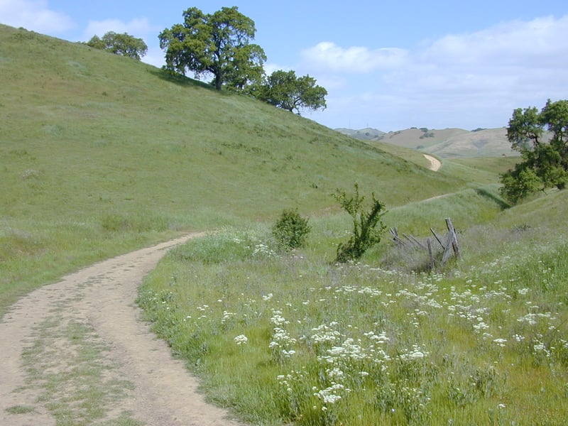
 Los Cerritos Trail sweeps uphill and bends
left. The trail climbs through some oaks; gooseberry and poison oak are common close to the ground. At
a flat spot, your climbing is rewarded with a view to the west, including
the hills of Almaden Quicksilver County Park, and beyond, to Mount Umunhum.
The grassy plateau on the left side of the trail is a perfect spot for
some lazy spring flower identification, or for a sunny snooze. Sprinkled
through the luxuriant lawn-like grass are popcorn flowers, Johnny jump-ups,
and creamcups. Los Cerritos Trail winds through some oaks, and renews
its climb. Oak Cove can be glimpsed back to the right. After a
short dip in elevation, Los Cerritos Trail climbs in earnest. If you find yourself
panting on the side of the path, be sure to look back behind you for a
great view of the reservoir. Los Cerritos finally exhausts itself and
ends at a signed junction with Peña Trail at 2.7 miles. (If you're
ready to head back to the trailhead, turn left onto Peña Trail
and descend to Oak Cove Trail, turn right and retrace your steps to
the trailhead.) Turn right on Peña Trail.
Los Cerritos Trail sweeps uphill and bends
left. The trail climbs through some oaks; gooseberry and poison oak are common close to the ground. At
a flat spot, your climbing is rewarded with a view to the west, including
the hills of Almaden Quicksilver County Park, and beyond, to Mount Umunhum.
The grassy plateau on the left side of the trail is a perfect spot for
some lazy spring flower identification, or for a sunny snooze. Sprinkled
through the luxuriant lawn-like grass are popcorn flowers, Johnny jump-ups,
and creamcups. Los Cerritos Trail winds through some oaks, and renews
its climb. Oak Cove can be glimpsed back to the right. After a
short dip in elevation, Los Cerritos Trail climbs in earnest. If you find yourself
panting on the side of the path, be sure to look back behind you for a
great view of the reservoir. Los Cerritos finally exhausts itself and
ends at a signed junction with Peña Trail at 2.7 miles. (If you're
ready to head back to the trailhead, turn left onto Peña Trail
and descend to Oak Cove Trail, turn right and retrace your steps to
the trailhead.) Turn right on Peña Trail.
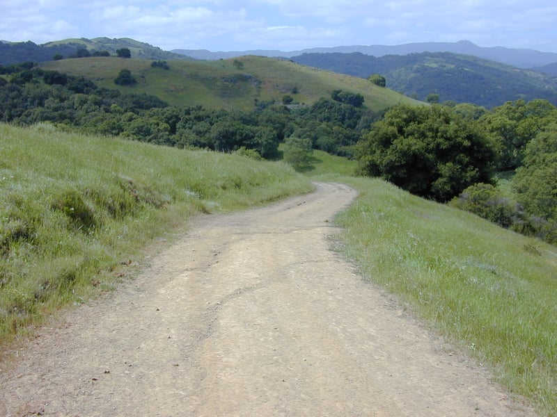
The wide dirt road continues the climb. As
you draw close to the crest, oaks and poison oak overtake the grassland.
A service road breaks off to the left; continue right on Peña,
which curves around the top of the hill and begins a downward stretch.
Javelina Loop is visible, and the mountains of the Sierra Azul stand in
the distance to the southwest. Peña Trail descends to a signed
junction beneath a grove of California bays at 3.1 miles. (If you want
to extend your hike 2.6 more miles, take Serpentine Loop Trail to the right.)
For the featured hike, take the trail to the left, Figueroa Trail.
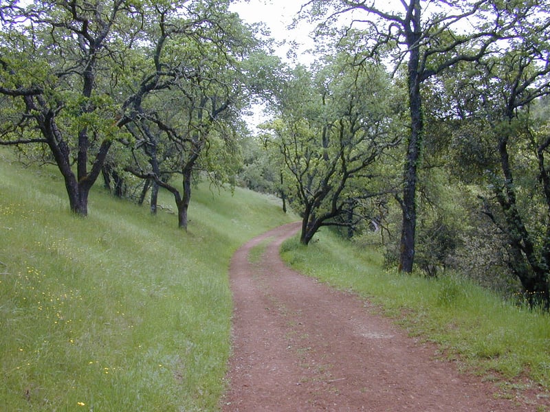
Figueroa Trail ambles downhill along a
creek. California sagebrush grows throughout a grass-
and oak-lined hillside in sporadic clumps on the left side of the trail.
As Figueroa Trail leaves the tree cover behind and
enters the edge of a meadow, this is a good spot to compare the different
vegetation zones of the area. The hills to the right (southwest) are forested;
the hills to the left (northeast) are lightly sprinkled with oaks, but
dominated by grassland. At 3.8 miles, Figueroa Trail meets Vallecito
Trail at a signed, but easy to miss junction. Turn left onto Vallecito
Trail.
This trail is open to hikers and equestrians.
Vallecito Trail is one of the best places in the bay area for an intimate
walk through grassland. The trail is so insignificant, especially at the
start, that you may have a "Sound of Music" moment and run through
the grass with your arms spread wide, singing "the hills are alive"
and whatnot. California poppies, filaree, fiddlenecks, Johnny jump-ups,
and bicolor lupine add brilliant color to the verdant grass in early spring. Deer may be
glimpsed in the distance. A small creek runs through the valley floor
downslope to the right. Vallecito Trail crosses a damp spot and then begins
to climb. Poison oak islands off the left side of the trail add a burst
of color to the hillside in the autumn when their leaves turn red. A few
oaks dot the slopes. As the path nears the crest, be sure to look back
for a lovely view of the valley. The unsigned junction with Peña
Trail comes into view, as Vallecito Trail ends at 4.3 miles. Turn
right onto Peña Trail.
The broad dirt fire road descends rather
sharply, affording terrific views of the reservoir, US 101, and Mount
Hamilton. At 4.5 miles, Peña Trail ends at the previously encountered
junction with Oak Cove Trail. Turn right on Oak Cove Trail
and retrace your steps back to the trailhead.
Total distance: 5.1 miles
Last hiked: April 16, 2002
Previous visit: March 20, 2000