Do
you know Coe? Serious bay area hikers and backpackers
will listen carefully when this question is uttered in their presence.
The uninitiated or indifferent might respond with an echoing question
of "what," "where," or even "who?" Some
non-hikers realize it's a park, but confuse it with one of the other south
bay "name" parks such as Joseph Grant or Ed Levin. A former
Coe employee and park volunteer says more common blunders are to confuse
Henry Coe with Henry Cowell (although the parks are many miles apart,
the names are similar), and to mistake Lake Anderson for Coe, as the
road to Coe passes by that county park. Coe veterans will regale listeners
with tales of frog and coyote serenades, star-filled night skies, and
week long backpacking expeditions. Other outdoor fanatics just don't know
about the toughest, largest park in the bay area. Coe, with 80,000 acres
(the biggest state park in northern California), became part of the state
park system in 1958. The park is former ranch land, and many trails are
old ranch roads. Most people visit the park
headquarters (about 8.5
miles north of the Hunting Hollow Trailhead), reached by East Dunne Avenue
near Morgan Hill. The park headquarters trailhead offers a visitor center
with bookstore and history exhibits, car camping, and access to the park's
most popular dayhiking and backpacking trails.
Numerous ponds, springs, creeks, and swimming
holes throughout the park provide fishing opportunities and the chance
to cool off on a hot day. China Hole, Coe's most popular swimming hole,
is the halfway point on a 10-mile loop on Madrone Springs and China Hole
Trails. Other day hikes beginning at headquarters feature views of the
Santa Clara valley and the Santa Cruz Mountains, groves of ponderosa pines,
 gigantic manzanitas, oak-studded hillsides, and Sada Coe's monument to
her father. Hike possibilities are nearly limitless at Coe; there's a
book's worth of material here, but lacking that your best bet is to obtain
the park map and start exploring.
gigantic manzanitas, oak-studded hillsides, and Sada Coe's monument to
her father. Hike possibilities are nearly limitless at Coe; there's a
book's worth of material here, but lacking that your best bet is to obtain
the park map and start exploring.
The Hunting Hollow Trailhead has few amenities,
but provides ample parking and 24 hour access. Hunting
Hollow Road is almost perfectly flat and is a good, easy introduction
to Coe. Since it's an out-and-back hike, it's suitable for kids or older
folks: just turn around when you get tired. If you seek a long challenging
hike, or a backpacking excursion, you can begin either at Hunting Hollow
Trailhead as well. There's a 8-mile loop to Willson Peak that climbs from
about 900 to 2651 feet, combining Lyman Willson Ridge Trail and Steer
Ridge Road/Trail. Unless you plan the simplest hike (out and back on Hunting
Hollow Road) make sure to bring plenty of water, and obtain a map in advance.
When I visited there were no maps at the trailhead, and as many trails
are unmarked, you risk the very real possibility of getting lost in this
vast wilderness.
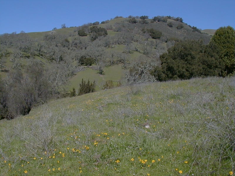
Spring is the peak season to visit. If you like
colorful landscapes, wildflowers are bountiful in late winter and spring,
and in autumn the leaves of deciduous oaks are conspicuous. Coe gets pretty
hot in the summer. If you visit Hunting Hollow in winter or spring, wear
waterproof boots; Hunting Hollow Road crosses the creek every chance it
gets (the park website says 18 times, but I didn't bother to count). At
most crossings you'll can hop across on strategically placed rocks, but
the water can be deep enough to reach your ankles if you must trudge through
(and it's cold).
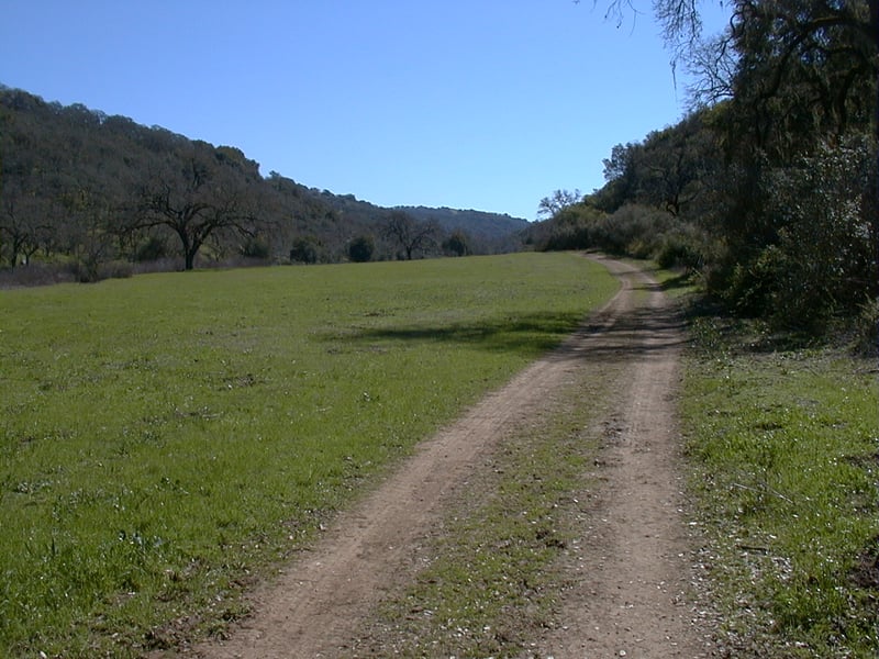
Start at the east end of the parking
lot. Walk around a gate onto Hunting Hollow Road, a broad,
dirt trail open to hikers, equestrians, and cyclists. Right away you'll
encounter your first creek crossing. An easy to miss junction with Steer
Ridge Trail is on the left. Sycamore trees line the creek, and their leaves
litter the ground at most crossings. Once on the other side of the creek,
you'll pass through the first meadow, which in late winter may be dotted
with popcorn flowers, baby blue eyes, and fiddlenecks. Rolling hills,
dotted with coast live and deciduous oaks, creep uphill to the north.
On the right side of the trail, you might see lots and lots of gooseberry,
as well as California coffeeberry and snowberry. As you pass through this
broad valley, Hunting Hollow Trail settles on a theme: cross a creek then
bisect a meadow. Rinse and repeat. The grade remains almost completely
flat. At about 0.76 mile, at a signed junction, a trail departs towards
Camp Willson on the left side of the trail. Continue on Hunting Hollow
Road.
A windmill sits off to the right side of
the trail just past the junction. This grassland has been infested with
yellow star thistle, and the park seems to be combating the weed by mowing
some meadows. Spring's fresh green grass is augmented by lots of wildflowers,
including great patches of baby blue-eyes, creamcups, fiddlenecks, popcorn
flowers, redmaids, johnny-jump-up, and johnnytuck. Squirrels have constructed elaborate burrows
under oaks and across the meadows, so you will probably see plenty of
the scampering bushy tailed animals near these colonies. Look in the dirt
for deer, coyote, and bobcat tracks, and be aware that wild pigs are sometimes
spotted as well. At about 1.8 miles (I'm guessing, because I didn't have
a map and wasn't sure where I was), a well-worn path heads uphill to the
left. The junction is unmarked, but the trail is a viable one, climbing
to Phegley Ridge. If you happen to be hiking in spring, you might climb
a few feet up the trail, and look to see what flowers are blooming. On
my visit in late winter, there were lots of johnny-jump-ups, the first
blue-eyed grasses of the year, and the tail end of the shooting stars'
bloom. These shooting stars are Padre's shooting stars, different from
the more common bay area mosquito bills. Padre's have light colored stems,
while mosquito bills' are purplish. When ready, continue on Hunting Hollow
Road.
The hills begin to close in on the road,
squeezing a broad valley into a canyon. In late winter, there are extravagant
displays of shooting stars on the sides of the trail. Hunting Hollow Road
begins a slight ascent. During the rainy season, look for a tiny waterfall
and pool on the left side of the road. California bay trees mix in with
oaks. At about 3.6 miles, Hunting Hollow meets Wagon Road at a signed
junction. Hunting Hollow actually continues straight to the park boundary,
but this is the turnaround point for this hike. (Option: take Wagon Road
uphill to Phegley Ridge Road, and then descend to Hunting Hollow Road
on Phegley Ridge Trail. This extension will add about 2.5 miles to your
day, and involves an over 1000 foot ascent.)You're likely to hear frogs
croaking melodically from the nearby creek, and as I sat and rested I
repeatedly heard gobbling from wild turkeys in the surrounding hills.
When you're ready, retrace your steps back to the trailhead.
Total distance: about 7.2 miles
Last hiked: Tuesday, March 13, 2001