Santa
Teresa County Park has a lot to love; acres of rolling
hills, serpentine soil that sustains many native plants and wildflowers,
and views in every direction. The only things missing here are the trail
signs! This Santa Clara County park is one of the poorest signed parks
in the bay area. If you visit you may want to bring a map with you in
case there are none in the park, because once you get out on the trails
you'll probably need some guidance, particularly since well-worn unsigned
paths are common.
The trailhead at Santa Teresa is about
500 feet, and the high point in the park is 1155 feet, so it's easy to
create a few easy or moderate hikes. The prime season to visit is spring,
for wildflowers along Rocky Ridge and Bernal Hill trails (also see Stile
Ranch page), but I have enjoyed the sun-baked chaparral and grassland
on a July morning, and bet on a clear winter day the views would be at their best. If you're interested in a family outing, there
are picnic tables at the Pueblo Day Use Area, and even a reservable group
 picnic area with a large barbecue pit, horseshoe pit, and volleyball area.
For the featured hike, start near the
restrooms across from the Pueblo Group Picnic Area. Begin hiking
uphill (to the left) on Mine Trail (part of the Bay Area Ridge
Trail). The wide dirt multi-use trail is unsigned (but for a Bay Area
Ridge Trail symbol), so do not wander off course steeply uphill on a path
that heads to private property; Mine follows along the park's road. The
trail quickly comes to a crest near an abundance of sagebrush, then drops
down and crosses a seasonal creek that sustains yellow (seep) monkeyflower
in late spring and early summer. Fiddlenecks are common
in spring throughout the grass. At 0.3 mile, Mine Trail ends at an undersigned
junction with Hidden Springs Trail. The only signage is via Bay Area Ridge
Trail symbols; turn right on Hidden Spring Trail.
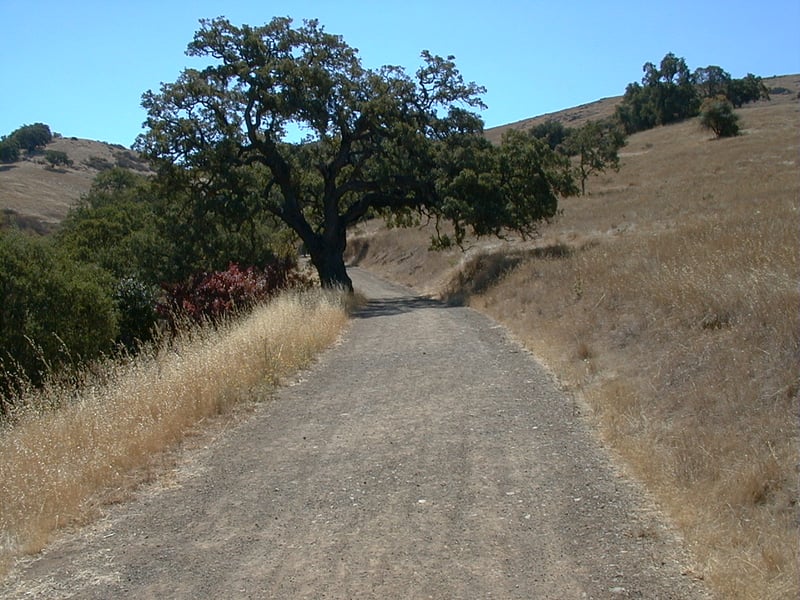
This wide trail, open to equestrians, cyclists,
and hikers, heads uphill to the east, initially passing through poison
oak, buckeye, and blue oak. After a gate, Hidden Springs, also part of
the Bay Area Ridge Trail, climbs a bit more steeply. There's a stream
on the right side of the trail, and moisture-loving plants such as elderberry
and California bay thickly line the creekbed. At 0.5 mile, Ridge Trail
begins to the left at a junction (now unsigned). Keep going uphill
on Hidden Springs Trail. Black sage, a chaparral plant commonly mixed
through other shrubs, occupies the hillside on the left. In spring, you
might see bluedicks, Chinese houses, and California poppy. Look for a
little pond (or damp green spot in the summer and fall) on the right. Hidden Springs ascends steadily until it ends at an unsigned junction at 0.9 mile. Stay to the right on Coyote Peak Trail.
Views to the east begin to open up, and
you may see hawks perched on the power lines above the trail. The broad
multi-use trail continues the climb that Hidden Springs Trail started,
sweeping uphill through grassland mixed with blue elderberry and coyote
brush. Ignore any unsigned paths and even more substantially worn trails,
persisting on Coyote Peak Trail to another undersigned junction at 1.3
miles. A large antenna and ugly building sit on the southeast side of
the peak, and the Boundary Trail sets out downhill the same direction.
Take the trail uphill to the peak, which makes a loop around the
crest. If it's clear you will be rewarded with views in every direction;
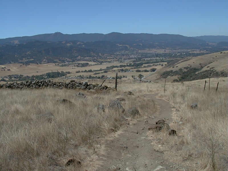 most notably Mount Hamilton to the east and the Sierra Azul to the west.
Return to the junction, which is only signed by a Bay Area Ridge
Trail "end of segment" marker. Head downhill to the west
on the Coyote Peak Trail.
most notably Mount Hamilton to the east and the Sierra Azul to the west.
Return to the junction, which is only signed by a Bay Area Ridge
Trail "end of segment" marker. Head downhill to the west
on the Coyote Peak Trail.
The trail drops and then climbs in a straight
line through grassland almost completely devoid of any trees or shrubs.
All the better for spotting wild turkeys as they shuffle through the grass.
In spring, you might see johnny-jump-ups and fiddlenecks. A
few steps before the little building at the crest of the hill, at 1.8
miles, look for an unsigned and narrow path that begins on the right side
of the trail (there's another small path that heads downhill east of Rocky
Ridge Trail; that trail is at the low point between two hills, while Rocky
Ridge Trail is at the top of the hill just before the little building).
Turn right onto Rocky Ridge Trail.
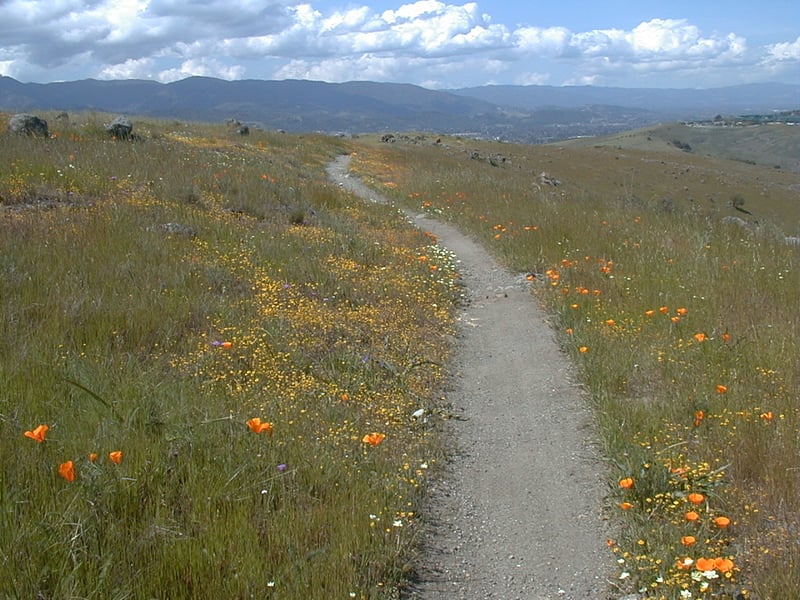
Rocky Ridge Trail, although multi-use,
is a mere whisper of a path. Serpentine rocks protrude from the grassland,
providing perfect conditions for springtime riots of flowers. Early April
wildflowers including creamcups, goldenfields, California poppies, popcorn
flowers, and tidytips congregate throughout the hillsides, forming pools
of vibrant color. Keep alert to bicycle traffic as you gape at the blossoms.
The descent is gradual, and the trail gets rockier as you continue. Rocky
Ridge Trail passes through an opening in a fence and winds past a large
California bay. Then the path curves around to the right, as it heads
east into Big Oak Valley. Soon California bay, toyon, California coffeeberry,and
poison oak edge near the trail. You may see wild buckwheat in the summer.
Rocky Ridge Trail draws near a creek, then turns to the left, continuing
to descend, and crosses a wooden bridge. The path climbs sharply for a
few feet, and meets an unmarked path coming in from the right. Stay
to the left on the main trail as it follows along the creek, which
is obscured by tangles of elderberry, blackberry and poison oak. In the
summer you might notice an expanse of yellow star thistle, a non-native
pest plant often kept under control in parks by grazing (there are no
cows here). The trail splits just before crossing a creek. Either trail
is an option, but for today, continue straight to the trail's end,
at an unsigned junction with Mine Trail at 3.6 miles. Turn right on
Mine Trail.
California coffeeberry and blue elderberry
are kept company by a large fig tree on the right side of the trail. Just
before crossing the creek (again), look for a splendid California coffeeberry
tree, one of the largest of these plants I have ever seen. As you get
close to a parking lot, at 3.7 miles, stay to the right and walk through
the corral, continuing on Mine Trail to the trailhead near the restrooms.
Total distance: 3.75 miles
Last hiked: April 4, 2001
Previous visit: July 10, 2000