Skyline
Ridge is one of my favorite spots to sit still. The hiking is great, but the two ponds are what makes this preserve so special to me. They are quiet, tranquil, meditative places, and usually empty on weekdays. The trails around
Alpine Pond and Horseshoe Lake are all-access
trails very close to parking, so if you want to share the outdoors with a mobility-challenged person (or are challenged yourself), Skyline Ridge is a great choice.
For the featured hike, start at the northernmost
parking lot and begin hiking on Ipiwa Trail (follow the signs
"to Alpine Pond"). The trail, open to hikers only, begins
in grassland, climbs slightly, then darts into a woodland comprised of
Douglas fir, coast live oak, big-leaf maple, California bay, and buckeye.
Springtime blooms include Chinese houses, yellow mariposa lily, and an
occasional fairy lantern. Deer are commonly spotted in these woods. Look
for thimbleberries at a dark and damp spot, and gooseberry, wild rose, and hazelnut on the shaded slopes. At
0.5 mile, the trail reemerges into grassland at a signed junction. From this junction the views to the west are
fabulous, even though Butano Ridge arches its spine, blocking the view of the ocean.
Fog sometimes collects in the southern crook of the hills, hanging across
the mountains like a canopy. Turn right.
 Sunny Jim Trail
heads somewhat steeply uphill, with coyote brush, coast live oak, madrone,
and some nonnative conifers on the sides of the wide fire road. When you
reach the crest of the hill, keep going straight past two undersigned
junctions (at 0.7 and 0.75 mile) with trails heading to the left. Across
the valley to the east, views are dominated by Monte Bello Open Space
Preserve, and Black Mountain(2800 feet). The elevation under your feet, at almost 2500 feet, is one
of the highest points in the Santa Cruz Mountains. The trail ushers you
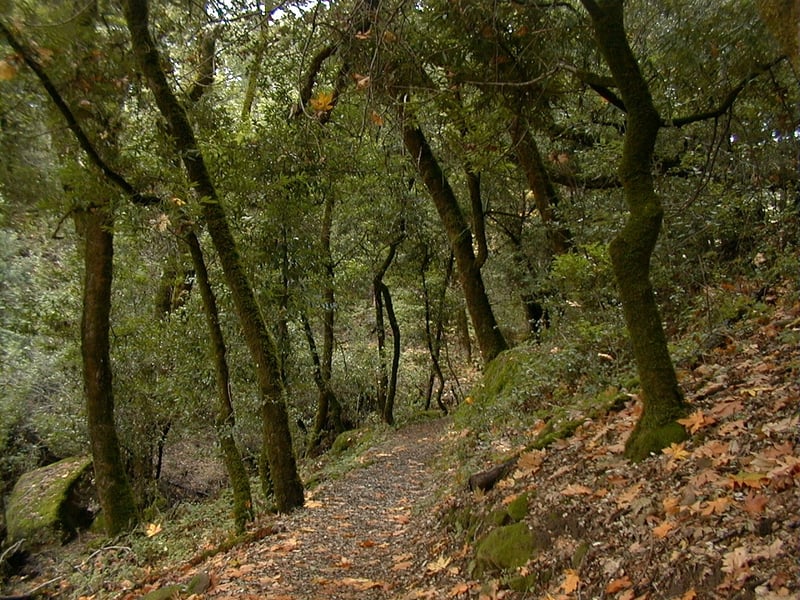
under the canopy of coast live oak, tanoak, and California bay as you
descend to the north. At 1.0 mile, at a signed junction, turn
right, toward Alpine Pond, remaining on the Sunny Jim Trail.
Sunny Jim Trail
heads somewhat steeply uphill, with coyote brush, coast live oak, madrone,
and some nonnative conifers on the sides of the wide fire road. When you
reach the crest of the hill, keep going straight past two undersigned
junctions (at 0.7 and 0.75 mile) with trails heading to the left. Across
the valley to the east, views are dominated by Monte Bello Open Space
Preserve, and Black Mountain(2800 feet). The elevation under your feet, at almost 2500 feet, is one
of the highest points in the Santa Cruz Mountains. The trail ushers you
under the canopy of coast live oak, tanoak, and California bay as you
descend to the north. At 1.0 mile, at a signed junction, turn
right, toward Alpine Pond, remaining on the Sunny Jim Trail.
You may catch a glimpse of a small stand
of lovely white poplar trees, their deciduous silvery leaves seeming to
sparkle in the wind. When you reach a paved service road at a signed
junction at 1.2 miles, turn left, then after a few feet,
turn right at a signed junction and walk downhill toward Alpine Pond.
Continue straight at a junction
with a trail that sets off to the left, marked "not
a through trail." Snowberry and creambush line the understory, where
you might see fairy lanterns and Chinese houses in spring. Turn right at the signed junction with
the Bay Area Ridge Trail segment at 1.3 miles.
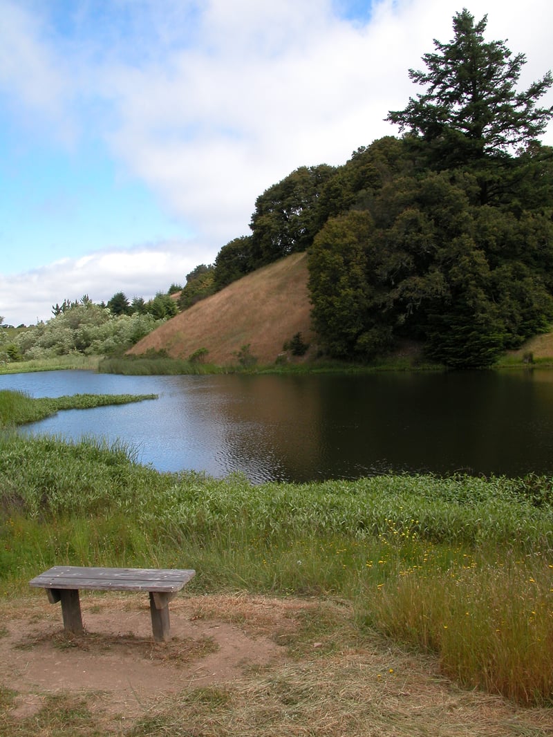
Follow the flat path around Alpine Pond. If you are hiking on a weekend day between mid-March and
November, the Daniels Nature Center may be open. If
not, let Alpine Pond draw you into its busy world. Fish, ducks, and turtles
disrupt the smooth surface of the water as they splash about. Crawfish
can sometimes be seen in the mud. And of course there may be birds
and brightly-colored dragonflies drifting about. There's a tiny platform
near the water's edge; a nice place to sit and bask in the sunshine. When
you return to a previous junction at 1.5 miles, turn right onto the Bay Area Ridge Trail/Ipiwa Trail
Take note of the sign warning about rattlesnakes, which
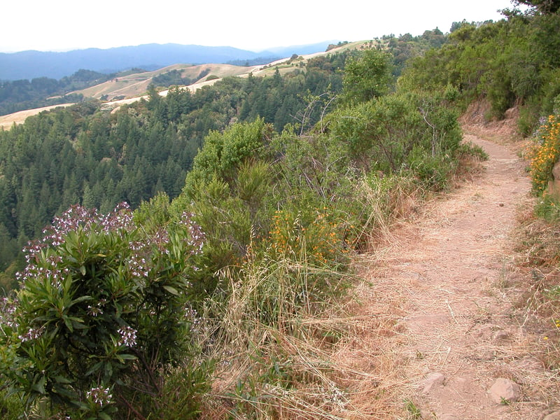
are active in warm weather on this stretch of hiking-only trail. I once got myself so worked up and panicky here that I literally scared myself with my own shadow. Now I try to stay calm, yet attentive to the trail. It's worth it; this portion features incredible views to the west. The trail starts out under cover of live oaks, then crosses a grassy hillside.
Then the trail creeps along the edge of the ridge. The ocean can be glimpsed, weather permitting. I often spot footprints of bobcat and/or coyote along this stretch. A bench dedicated to Norbert Eberhardt, a hiker who died
while visiting this preserve in 1999, is a fitting location for a rest
 break. Some rocks look inviting to climb, but note the poison oak, and the long drop off the side of the hill. There
is an easy-to-miss junction near the most prominent rock formation (where
a fence and trail have been built into and around the rock), at 2 miles. The
path to the left climbs up to meet the crest of the hill, but stay
to the right, go around the rock, and continue through chaparral,
mostly comprised of chamise, ceanothus, pitcher sage, monkeyflower, coyote
brush, toyon, California sagebrush, holly-leaf cherry, and manzanita. You might also see silktassel and cercocarpus. Ridge Trail dips beneath some live oaks, then emerges to a fantastic view south, with Mount Umunhum
visible on a clear day. As the trail curves to follow the contour of the
hill, it cuts through a slope of land that has been overtaken by yellow
star thistle, an invasive, nonnative pest. You might see owl's clover
in early spring, and clarkia, yellow mariposa lily, and brodiaea later in the season. At a
previously encountered junction at 2.4 miles, turn right and head
downhill toward Horseshoe Lake.
break. Some rocks look inviting to climb, but note the poison oak, and the long drop off the side of the hill. There
is an easy-to-miss junction near the most prominent rock formation (where
a fence and trail have been built into and around the rock), at 2 miles. The
path to the left climbs up to meet the crest of the hill, but stay
to the right, go around the rock, and continue through chaparral,
mostly comprised of chamise, ceanothus, pitcher sage, monkeyflower, coyote
brush, toyon, California sagebrush, holly-leaf cherry, and manzanita. You might also see silktassel and cercocarpus. Ridge Trail dips beneath some live oaks, then emerges to a fantastic view south, with Mount Umunhum
visible on a clear day. As the trail curves to follow the contour of the
hill, it cuts through a slope of land that has been overtaken by yellow
star thistle, an invasive, nonnative pest. You might see owl's clover
in early spring, and clarkia, yellow mariposa lily, and brodiaea later in the season. At a
previously encountered junction at 2.4 miles, turn right and head
downhill toward Horseshoe Lake.
Sunny Jim Trail, open to equestrians,
hikers, and cyclists, drops easily downhill through coyote brush and more
Christmas tree farm escapees. At 2.8 miles, turn right at a signed
junction, continuing toward Horseshoe Lake. As you descend, the sounds
of the lake will probably drift up to meet you. Blue-eyed grass is common
in early spring. Lambert Creek Trail (not a through path) departs to the
right at a signed junction at 2.9 miles. Continue straight a few steps more to the lake
and a signed junction. (There's a bench just
past this, near the water, that makes a good lunch stop.) Turn left
onto a full-access section of the Ridge Trail.
The path is open to hikers (and wheelchair
users) only. It takes a level tack along the shore of the lake, through
coyote brush and willow. I saw a bobcat here once, and often see
their tracks in the soft mud around the water. Shy ducks squawk in alarm
at outsiders. Iris are lovely in early spring on
the left. At a bridge crossing, look to the right for a cloud of snowberries
in autumn. The trail switchbacks gently uphill, and reaches the handicapped
parking lot at 3.1 miles (you can take either path at a split; the trail
left is at a wheelchair accessible grade, but the stairs dump you out
into the parking lot immediately). Cross the lot and look for the signed
continuation of the trail. This last stretch of the
hiking-only path passes levelly through coyote brush and marshy grassland.
In late summer, the blush of buckwheat in bloom shades the grass a strange
pink. At about 3.3 miles, the path ends back at the trailhead.
Total distance: 3.3 miles
Last hiked: April 3, 2012
Previous visits: November 14, 2000 and May 23, 2001