Briones
Regional Park features four major trailheads with many loop possibilities. Abundant loops everywhere, that is, except from this trailhead, where you hike about 1.75 miles
and climb over 600 feet in elevation before you reach a major junction.
The Lafayette Ridge Trailhead is convenient, less than a mile north of
CA 24, but after hiking the Lafayette Ridge Trail you may consider
the proximity a mixed blessing, as traffic noises drift up the ridge top. The
Reliez Valley Trailhead, a few miles north of the Lafayette Ridge Trailhead,
has a small lot, and the first 1.5 miles of the trail edge between housing
developments (with lots of cows along, and sometimes on the trails). The
three other trailheads, Bear Creek, Alahambra
 Valley, and Briones Ridge Road, collect entrance fees, but deliver you
to the heart of the park immediately, and offer expanded amenities.
Unless you have a profound dislike of cows, there's a lot to love at Briones,
so you might explore the trailheads and see which one(s) you like best.
Valley, and Briones Ridge Road, collect entrance fees, but deliver you
to the heart of the park immediately, and offer expanded amenities.
Unless you have a profound dislike of cows, there's a lot to love at Briones,
so you might explore the trailheads and see which one(s) you like best.
For this featured hike, enter
the park from the parking lot, and take the right trail uphill a few
yards. Go through the gate and then follow the broad fire road
uphill. A leaning sign post is easy to miss at the first junction. Go
to the left on the Lafayette Ridge Trail. A gradual climb through
grassland takes you around a farm in the crease of the hills. The
trail can be very muddy after rain, even before the cows muck it up. At
the next unsigned junction, turn left and continue to walk uphill.
An old, abandoned ramshackle farm building comes into view on the left
side of the trail. On a hike in November along here I saw a flock
of tiny yellow goldfinches flying from tree to hillside and back again, over and over. They were so small
that each could sit on a blade of dry grass without bending it. After
the trail passes the building, it reaches a flat, then turns uphill again. There
are plenty of animal paths near here, so when in doubt about the trail,
just keep climbing on the wide road. Some oaks creep close to the
trail on the north side of the trail. A small path (the Briones to
Las Trampas Trail) breaks off and heads south. Continue uphill on the
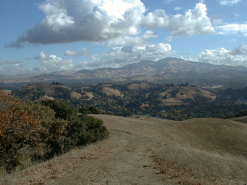
Lafayette Ridge Trail. Views of Mount Diablo are outstanding the entire
 hike, and as you climb higher you have great perspectives in all directions:
Las Trampas to the south, Berkeley hills to the west, Suisun Bay to the
north.
hike, and as you climb higher you have great perspectives in all directions:
Las Trampas to the south, Berkeley hills to the west, Suisun Bay to the
north.
At about 0.7 mile, go through
a gate and continue straight at an (under)signed junction. The
trail dips down for a few yards, then turns away from a locked gate marking the park's boundary; turn to the north on a multi-use singletrack trail. You
may notice that on the "share the trails" sign at the start of this section
the words hikers and equestrians have been scratched in an attempt to
obliterate them, leaving the word bicyclists intact. Everyone's a critic
of park management, apparently. The short portion of trail skirts
a large lovely house, then broadens again at a damp seep, and continues
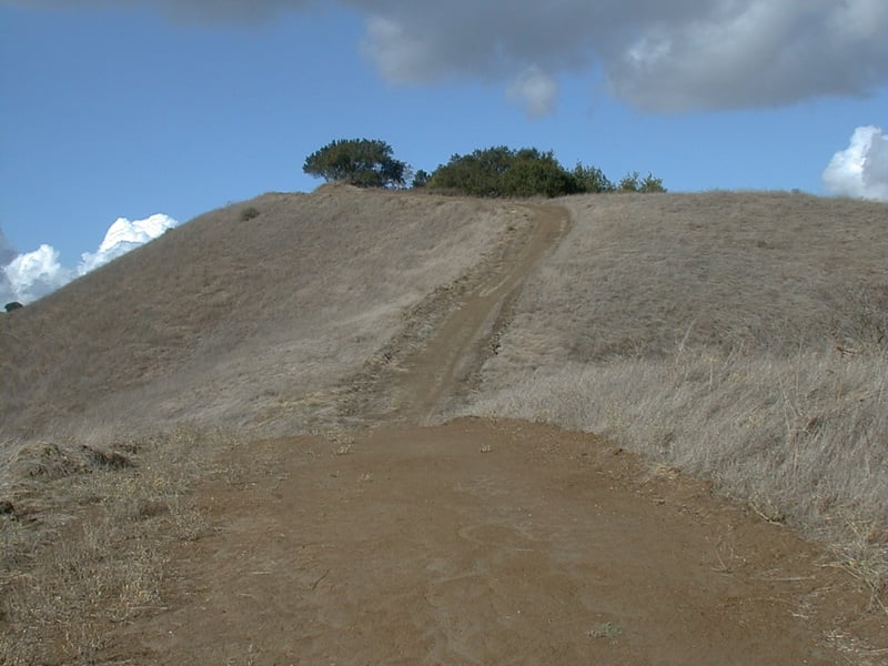
uphill. It then delivers you to a very poorly signed junction under an
oak tree. Basically it's a 4 way junction. The trail to the
east (right) goes to the road, then ends, and the trail to the left, which
is signed, crests at a shady hill, then drops down and ends at a construction
site. You want to go straight (a quick right and then left), but
from the junction you can barely see that the trail goes that way, and it's
unmarked. The photo of this junction doesn't help much; look to the
water tank, then down, and you'll see it.
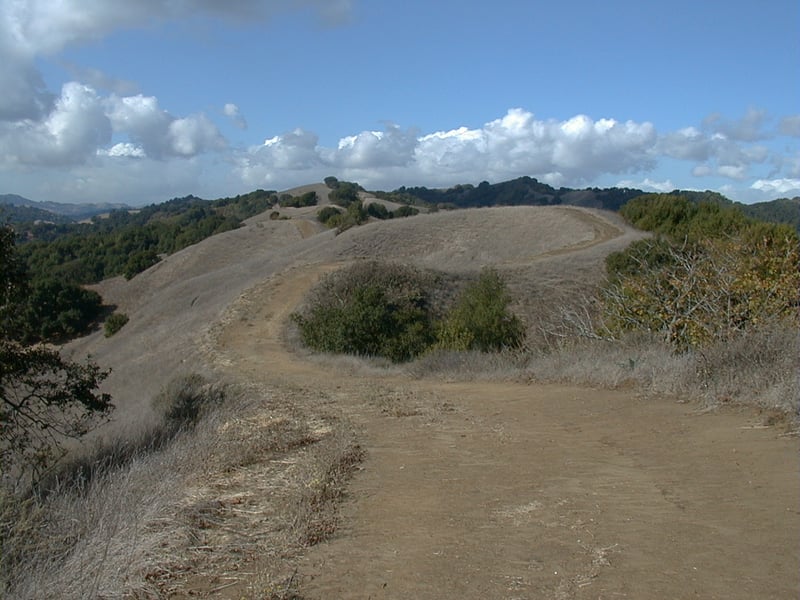
Continuing on the Lafayette
Ridge Trail, this next section of the park, away from the houses, is
the nicest stretch of this hike. At about 1.6 mile, a whisper of
 a path through the grass marks the start of the Springhill Trail. I've
never been on this trail, so I can't vouch for it. If it wasn't signed
I certainly would have missed it; it resembles a deer path more than a
trail. Springhill Trail descends into a canyon to the north, then connects
with the Buckeye Ranch Trail, which climbs back up to the Lafayette Ridge
Trail. This option would add about 1.5 miles, and significant elevation
change, to your hike.
a path through the grass marks the start of the Springhill Trail. I've
never been on this trail, so I can't vouch for it. If it wasn't signed
I certainly would have missed it; it resembles a deer path more than a
trail. Springhill Trail descends into a canyon to the north, then connects
with the Buckeye Ranch Trail, which climbs back up to the Lafayette Ridge
Trail. This option would add about 1.5 miles, and significant elevation
change, to your hike.
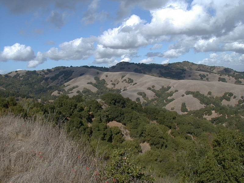
Continue on the Lafayette
Ridge Trail, and look for deer, coyote, and bobcat prints in the soft
mud after a rainstorm. The Lafayette BART station is visible to the
south, and all this climbing has not reduced the traffic soundsfrom
CA 24 much. As the trail rises and climbs repeatedly like the tracks
of a roller coaster, views of the trails to the north get even better.
Although this trail is not part of the Bay Area Ridge Trail system, I
find it the archetypal ridge trail, hugging the contours of the crest,
with views unobstructed by trees. A few maples cling to the hillside of
the north slope among the many oaks, beneath the ridge line. Yellow star
thistle grows down the middle of the trail in sections. When muddy, the
hills can be a challenge to ascend and descend, as your feet slide in
every direction. You can turn around wherever you please, but the logical
spot is at about 2 miles, at the crest of the Lafayette Ridge. I
love the view to the north from here, and admire the Briones Crest Trail,
no wider than the ridge at sections. It makes me think of walking
on the edge of a knife. From here you could also extend your hike by continuing to the end of Lafayette Ridge Trail, then making a balloon out of the Russell Peak Trail and
Mariposa Trail, for an additional 2.6 miles. For this featured hike, retrace
your steps from this junction back to the trailhead.
Total distance: about 4.1 miles
Last hiked: Monday, November 8, 1999