I've
always thought that climbing a bay area peak is somehow
more palatable when I can see the summit from the trailhead, and throughout
the hike. When I have a mountain in my sights, it can't get away from
me, and throw an unexpected sharp grade at me when I'm not looking. And
then there's the visual inspiration to hold my attention as I'm slogging
my way uphill toward the goal. Motivation is a key element when you prepare
to climb Mission Peak the first time (and perhaps after that as well).
The trails climb about 2000 feet in less than 3 miles.
Fit hikers should have not problem with this 6 mile hike, and beginners
in reasonable shape may find the ascent tough, but manageable, with proper
pacing and plenty of water.
Hikes at Mission Peaks are best taken on
cool days. There is virtually no shade on the ascending fire road and
trail. No escaping chilly winds either, so bring a windbreaker or jacket along.
Although the park is grazed by cows (some
 of whom are particularly aggressive), the lush green hills bring wildflower
lovers to Mission Peak in spring. The cows create muddy trails during
wet months, and lumpy paths later when things dry out a bit. There is
so much cow traffic that in late winter I found Horse Heaven Trail to
be a difficult to navigate sloppy mess where I nearly expired in a quicksand-like
mud trap probably rigged by the cows (more on that later). This is one
park where it may be better to stick to the fire roads.
of whom are particularly aggressive), the lush green hills bring wildflower
lovers to Mission Peak in spring. The cows create muddy trails during
wet months, and lumpy paths later when things dry out a bit. There is
so much cow traffic that in late winter I found Horse Heaven Trail to
be a difficult to navigate sloppy mess where I nearly expired in a quicksand-like
mud trap probably rigged by the cows (more on that later). This is one
park where it may be better to stick to the fire roads.
The out-and-back hike to the summit is the
preserve's most popular route. Hikers looking for a longer excursion can
continue from the summit on the Bay Area Ridge Trail all the way past
Monument Peak to Ed Levin County Park. The 14 mile out-and-back trek pales
in comparison to the 28-mile Ohlone Wilderness Trail, which departs from
Mission Peak. This hiking and equestrian trail (which requires a permit)
travels through Sunol Regional Wilderness
and ends up near Lake Del Valle. Mission Peak's proximity to Fremont makes
it possible get off a bus a few blocks from the park, and then backpack
on the Ohlone Wilderness Trail for three days without worrying about your
car (of course, you'll have to arrange a ride home).
Mission Peak has become increasingly popular; so much so that parking is tough to find at the Stanford Avenue traihead, even on a weekday. I highly recommend beginning at Ohlone College (details in sidebar, to the left). Parking at Ohlone College is easy. The $4 parking fee is worth it -- I hate worrying about arriving at the trailhead with no parking spots. And the hike to the Mission Peak summit is slightly easier from Ohlone College and (in my opinion), much nicer (less crowed for sure). From the parking structure, cross the street and walk to the signed trailhead. Begin climbing on the signed Bay Area Ridge Trail segment/Peak Trail. It's a steady ascent through grassland for 1.1 miles, then the trail levels out slightly near a small pond. After climbing easily though California bays along Mill Creek Road, the trail swings back into grassland and the grade picks up -- just keeping following Peak Trail all the way to the summit.
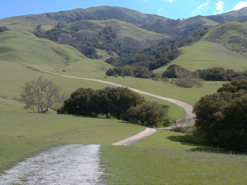
For the featured hike, start at the gate
at the edge of the parking area. The trail splits immediately. Stay
to the left on Hidden Valley Trail. After a brief descent, the broad
fire road, open to cyclists, equestrians, and hikers, crosses a sycamore
and oak-lined creek and then begins an ascent. Walking through the first cattle gate can feel
like passing into the initial circle of Dante's Hell. Legs used to more
reasonable grades may register a mild protest. Tell them to shut up and
keep moving. As you climb you may notice shortcuts carved through the
grassland at many spots. These paths are even steeper than the fire road,
but some hikers use them for shorter trips to the top. While it's nearly
senseless to encourage strict trail use when
the cows go wherever they want, it can be confusing to choose the "proper"
trail when shortcuts are so well worn, so stay on the fire road. Hidden
Valley Road draws near a creek at several points as the trail curves uphill,
 and here you'll find a little shade from coast live oaks and California
bays. You might see or hear wild turkeys shuffling across the hills or
gobbling back and forth to each other, while vultures and hawks soar overhead.
At one point you'll pass through a stretch of chaparral, with poison oak,
sagebrush, and monkeyflower along the trail. Buckeyes and oaks soak up
moisture on the right, in a damp crease. But soon you'll pass back into
pure grassland. At 1.5 miles, Hidden Valley Trail reaches a signed
junction with Peak Meadow Trail. (If you want to shorten your hike, turn
right on Peak Meadow, which will deliver you back to the trailhead.) Continue
straight on Hidden Valley Trail.
and here you'll find a little shade from coast live oaks and California
bays. You might see or hear wild turkeys shuffling across the hills or
gobbling back and forth to each other, while vultures and hawks soar overhead.
At one point you'll pass through a stretch of chaparral, with poison oak,
sagebrush, and monkeyflower along the trail. Buckeyes and oaks soak up
moisture on the right, in a damp crease. But soon you'll pass back into
pure grassland. At 1.5 miles, Hidden Valley Trail reaches a signed
junction with Peak Meadow Trail. (If you want to shorten your hike, turn
right on Peak Meadow, which will deliver you back to the trailhead.) Continue
straight on Hidden Valley Trail.
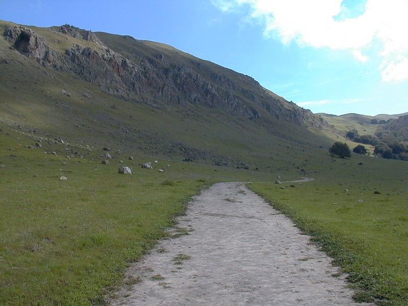
Hidden Valley Trail continues to climb.
On a hike in late winter, I watched a cow and her two calves running and
bucking through the grass. Spring was definitely in the air. After almost
2 miles of calf-aching ascending, the trail flattens out and enters a
rocky valley. There are nice views to Mission Peak's craggy west face
and summit. At 2.2 miles, Moore Grove Trail begins on the right side
of the trail at a signed junction. Continue uphill to the left on Hidden
Valley Trail.
You may see hang gliders swooping down
toward the trailhead as you approach their launch site on the left. In
early spring, look for patches of orange-yellow fiddlenecks in the grass
on the right. At 2.3 miles, you'll reach a signed junction. The trail
to the left heads toward Ohlone College. Bear right and remain on Hidden
Valley Trail. A few steps later, there's a cattle gate
and another signed junction. Bear right on Peak Trail.
I had heard that Mission Peak's cows are
feisty. One cow, part of a group grazing near the pit toilet just down
the trail to the left, was particularly aggressive on the day I visited.
The spunky bovine mama mooed loudly, repeatedly and with urgency, slowly
trotting toward me in a menacing way. I was heading away from the cows
and as I gained some distance she calmed down. Although we might not think
of cows as wildlife, it's a good idea to give them a wide berth on the
trails. And by the way, although you might not expect them to, the cows
 graze all the way up to the summit, and even can be spotted on the incredibly
steep and rocky west face of the peak. Crazy!
graze all the way up to the summit, and even can be spotted on the incredibly
steep and rocky west face of the peak. Crazy!
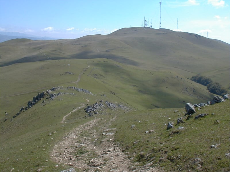
Peak Trail, part of the Bay Area Ridge
Trail, is a broad multi-use trail. Mission Peak's treeless high hills
afford views to many bay area parks and preserves along Peak Trail, and
all the way to the summit. Just north is Garin/Dry
Creek Pioneer, a bit further north and east is Mount Diablo, to the east
you should be able to pick out Sunol, and a look west may reveal Coyote
Hills (on the edge of the bay). On clear days you might be able to see
the Sierra, Mount Hamilton, and the Santa Cruz Mountains. After a short
stretch on Peak Trail, you'll reach a signed junction with Eagle Trail
at 2.6 miles. Turn right, remaining on Peak Trail, and prepare for the final
climb to the summit.
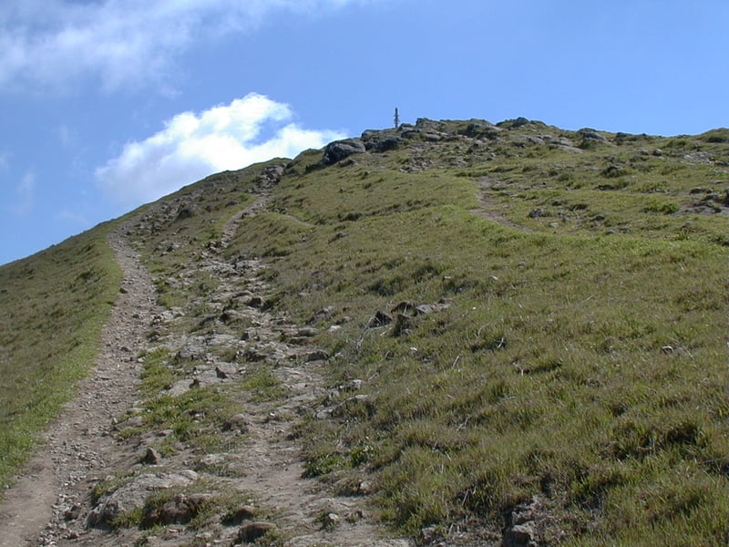
There's a short harsh grade, then the path,
open to equestrians and hikers only, flattens out a bit. Peak Trail turns
left near some garbage cans and pushes towards the top. The trail is rocky
and steep. A few other side paths run along Peak Trail here and there.
Finally at 3.05 miles, you'll reach Mission Peak's rocky summit. There
are excellent views in every direction. On a hot day you'll probably welcome
the breeze, but if it's chilly you might not want to linger. Popcorn
flowers, California poppies, and fiddlenecks dot the surrounding grassland
in early spring. When you're ready, retrace your steps to the trailhead.
Option: If you're adventurous and have
good navigating skills, descend south from the summit to the signed junction
with Horse Heaven Trail. Take Horse Heaven Trail, stay to the left at
an unsigned junction near a creek, continue to Peak Meadow Trail, turn
left (the junction is marked by a blank post) and return to the trailhead.
Mileage is about the same as the featured hike. When I tried Horse Heaven in late winter,
the trail, open to equestrians and hikers only, was a mess. If I chose
the trail names at the East Bay Regional Park District I think I would
dub Horse Heaven/Hiker Hell Trail. Cows had created muddy spots and confusing
alternate paths. I got one leg stuck up to my knee in a muddy quicksand-like
patch, and struggled for what seemed forever until I managed to free myself.
No doubt this was a trap hatched by those nasty cows. I expected them
to show up at any moment, and then who know what would have happened!
Caked with mud and with squishy stuff in my boot, I struggled on, only
to lose the path completely near a water trough. I ended up traveling
cross country through the grassland, eventually reuniting with the actual
trail. All in all, a lousy experience. Perhaps the conditions are more
manageable in drier seasons, but I wouldn't recommend this option in winter
or early spring.
Total distance: 6.1 miles
Last hiked: Friday, March 16, 2001