With
all the amazing parks and
preserves in the bay area, it's nearly impossible for me to pick a favorite,
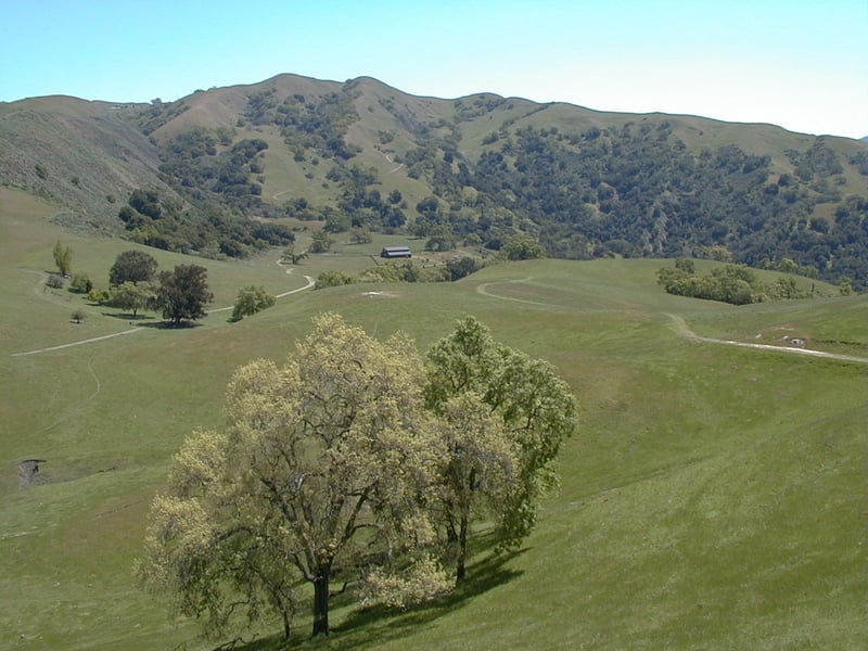
but I know that Sunol Regional Wilderness is on
my short list. Sunol is a large protected parcel of land, with a plethora
of plant communities, and plenty of trails through varied terrain. Many
of the trails seem to be slightly tougher than average, making Sunol an
appropriate destination for long, challenging hikes. The preserve also
abuts Ohlone Regional Wilderness, a rugged chunk of land perfect for weekend
backpacking expeditions. Hikes from Sunol can be extended east all the
way to Del Valle Regional Park, and west to
Mission Peak Regional Preserve (permit
required for Ohlone Wilderness Trail).
Inside Sunol, there are plenty
of loop hikes, but if you haven't visited the preserve before, consider
choosing a medium-length trek. The steep trails can really wear you out,
especially in the summer, when Sunol gets seriously hot. A popular loop
combines Canyon View Trail with
Camp Ohlone Road, an under 3-mile jaunt that visits the Little Yosemite
 Area. Another choice is the Maguire Peaks Loops, which explores the northern
part of the preserve, and is less than a 4-mile commitment. Tougher hikes
climb from the trailhead to Sunol's highest accessible peaks; Cerro Este
Road skirts two spires over 2,000 feet.
Area. Another choice is the Maguire Peaks Loops, which explores the northern
part of the preserve, and is less than a 4-mile commitment. Tougher hikes
climb from the trailhead to Sunol's highest accessible peaks; Cerro Este
Road skirts two spires over 2,000 feet.
For the featured hike, start at the edge
of the parking area, and walk a few feet to a footbridge. Cross Alameda
Creek and consult the map (if necessary) at the junction. Turn right
on Canyon View Trail.
Common moisture-loving trees alder, bigleaf maple,
coast live oak, buckeye, and sycamore line the level trail. At 0.05 mile,
Hayfield Road begins on the left. Continue straight on Canyon View,
and stay to the left as a wide path veers right after a few steps.
The trail follows along the creek. Ignore an
ascending path to the left and continue
on level Canyon View Trail. At 0.15 mile, just past a creek crossing,
Indian Joe Creek Trail sets off to the left at a signed junction. Turn
left.
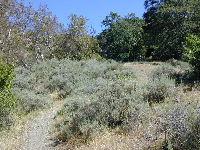
The first part of this hiking only path
is a self-guided nature trail (get the handout at the Interpretive Center
or Visitor Center). Climbing slightly, with California sagebrush, common
snowberry, and wild rose in the understory, the path reaches a break in
the vegetation. Look to the right (southwest) for views toward Mission
Peak Preserve. At the crest of a small hill, wildflowers thrive in the
spring. You may see wind poppy, Chinese houses, and mule ear sunflowers
in April, and elegant clarkia and California delphinium in late May (visit
the wildflowers page for photos). Canyon
View Trail departs (again) from the right side of the trail at a signed
junction at 0.4 mile. Stay to the left on Indian Joe Creek Trail.
The narrow path squeezes past a toyon bush, then
drops down to a wet spot. Enchanting and lovely fairy lanterns bloom along the trail in April. Look
for the delicate pink-white flowers on snowberry shrubs in June. Indian
Joe Creek Trail climbs easily along a shaded stretch of stream, then crosses
through a gate and begins a climb through a broad grassy canyon. A few
white oaks and sycamores provide occasional shade. Spring flowers include
bluedicks and California buttercups. In late May elegant clarkia blooms
in profusion along the trail. Sagebrush is common, and you may also see
bluewitch nightshade, poison oak, coyote brush, California coffeeberry,
and bush monkeyflower. The trail dips down to cross the creek near an
old California bay tree, then crosses back to the left bank. Indian
Joe Creek Trail fords the stream once more, then turns away from the water and
 begins to climb in earnest. Coast live oaks share the sunlight with California
bays and maples. A few switchbacks break up the grade, but there are some
steep stretches.It's hard to believe that cows would choose to graze
through here, with such lovely level roads elsewhere in the preserve,
but their occasional patties are telltale signs that they too have hiked
this trail. In summer I have come across groups of them, huddled together
in the shade. At 1.3 mile, a spur path to Hayfield Road starts on the
left side of the trail at a signed junction. (If you want to shorten your
hike, you could turn left, walk to the junction with Hayfield, then turn
left and descend back to the trailhead.) Continue uphill on Indian
Joe Creek Trail.
begins to climb in earnest. Coast live oaks share the sunlight with California
bays and maples. A few switchbacks break up the grade, but there are some
steep stretches.It's hard to believe that cows would choose to graze
through here, with such lovely level roads elsewhere in the preserve,
but their occasional patties are telltale signs that they too have hiked
this trail. In summer I have come across groups of them, huddled together
in the shade. At 1.3 mile, a spur path to Hayfield Road starts on the
left side of the trail at a signed junction. (If you want to shorten your
hike, you could turn left, walk to the junction with Hayfield, then turn
left and descend back to the trailhead.) Continue uphill on Indian
Joe Creek Trail.
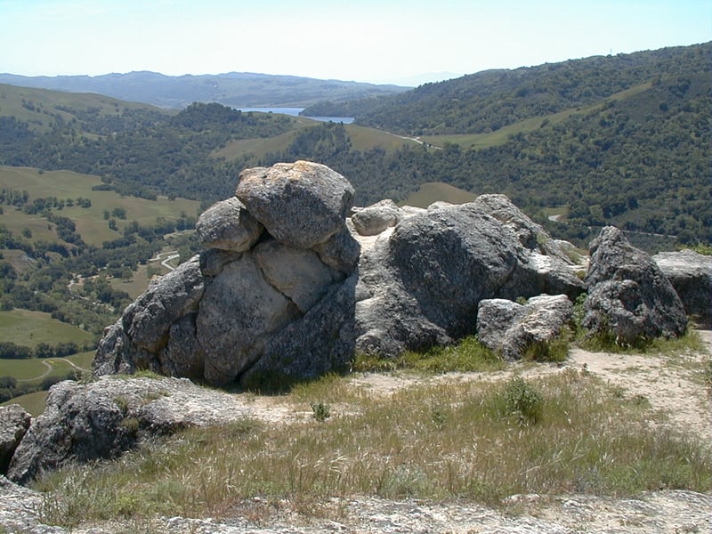
The trail continues to climb, passing through
clumps of sagebrush that on one spring hike were tangled with blooming
morning glories. Tall sycamores on the left side of the trail surround
Indian Joe Caves, a basalt outcrop that may remind you of rock formations
at Pinnacles National Monument. As the trail continues
to climb, with some steep sections tempered by a few level stretches,
sagebrush-coated hills come into view to the north. The final very steep
stretch of Indian Joe Creek Trail can feel like an insult on a hot day. At 1.6 miles, Indian Joe Creek Trail ends at a signed junction. (Cave
Rocks Trail continues uphill to the right, and if more climbing is what
you're after, you can hike up to the ridge on Eagle View Trail, then take
Vista Grande Road west and continue the featured hike from the junction
of High Valley Road and Flag Hill Road.) For this hike, turn left on
Cave Rocks Road.
After dipping downhill to cross the creek
one last time, the nearly level multi-use fire road sweeps through grassland,
with only a few valley oaks to break up views to the southwest. Popcorn
flowers carpet the hills in the spring, along with the diminutive blossoms
of filaree and scarlet pimpernel. You may catch a glimpse of turtles sunbathing
on logs floating in a small pond on the right. High Valley Group Camp
comes into view as Cave Rocks Road curves around a hill. At an undermarked junction
at 2 miles (the signpost is down the trail toward the group camp),
Cave Rocks Road meets Hayfield Road and High Valley Road. (Hayfield heads
to the left back down to the trailhead, and is an option if you want to
cut this hike short.) High Valley Road supersedes Cave Rocks Road, so
continue straight on High Valley Road.
Airplane traffic noise is common, but otherwise
this is a very quiet part of the park. The broad trail meanders toward
two oaks (the giant eucalyptus that once stood here has fallen), and a signed junction, at
2.3 miles. From here, High Valley Road continues 0.4 mile to its demise
 at Welch Creek Road. The barely discernible (at least in spring) Vista
Grande Road departs to the right, on its way uphill to the ridge line.
Turn left and hike uphill on Flag Hill Road.
at Welch Creek Road. The barely discernible (at least in spring) Vista
Grande Road departs to the right, on its way uphill to the ridge line.
Turn left and hike uphill on Flag Hill Road.
The trail, open to horses, hikers, and
cyclists, is a reasonable grade, but you may stop frequently anyway just
to take in the views. The Maguire Peaks poke their rocky crests up to
the north, and a look back reveals the gorgeous
high valley you've just traversed, and the higher still peaks of Sunol's
eastern section. Spring flowers downslope off the trail include fiddlenecks,
lupines, California buttercups, and blue-eyed grass. A few oaks clustered
together provide a little shade, but Flag Hill Road is mostly grassland.
The grade picks up a bit, but after passing a rock outcrop on the right
side of the trail, Flag Hill Road curves left and crests. A flat stretch
along the ridge is welcome. As the trail nears Flag Hill, expansive views,
including Calaveras Reservoir, unfold at your feet. Owl's clover, purple
bush lupine, and bellardia are common in May, and later in June look for
beautiful white mariposa lilies rising above the dried grass. A rock
signpost marks the junction with Flag Hill Trail at 3 miles. Continue
straight.
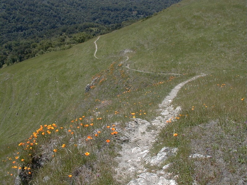
A slightly narrowed path continues a short distance along
the ridge to the west, then reaches a rock outcrop.
If you've got kids in tow, keep them close, for there's a sharp
unfenced dropoff. The dramatic fossilized sandstone rocks make a fine
lunch stop, unless you're scared of heights. Their elevation puts you
in the unusual position of looking
down on birds of prey as they soar over the grassland below. Horehound,
deerweed, and coyote mint grow in clusters around the formation. In spring,
look downhill for swaths of orange California poppies. A 1 mile loop continues to the west if you
want to extend your day. For the featured hike, when you're ready
to continue, walk back to the previous junction and turn right on Flag
Hill Trail, which is open to hikers only.
Seen from a distance, this slight path
resembles a randomly draped white shoestring. Flag Hill Trail cuts through
the grassland, somewhat steeply at times. Sagebrush and poppies border
the trail, which is rocky and can be slippery, so descend with care --
a trekking pole or two is helpful. On the other side of a cattle gate,
tall grass and thistles crowd the trail. On one hike, I watched an escaped
bovine feasting on a mustard patch, alone at the bottom of a valley. He
seemed to be in heaven. As Flag Hill Trail winds downhill, more oaks and
California bays encroach into the grassland. Blue jays may notice your
presence and sound their sharp alarms, letting the neighborhood know a
stranger has invaded their space. On one hike I nearly stepped on a skink
(every time I see a skink I nearly step on it) as it sat motionless near
the side of the trail. At 4.2 miles, a gate marks an unsigned junction.
Shady Glen Trail climbs to the left. Continue downhill to the right
on Flag Hill Trail.
After just a few more steps, Flag Hill Trail
ends at an unsigned junction at 4.3 miles (Flag Hill Trail is signed,
but not the other trail). Turn left and walk along Alameda Creek,
on a wide shaded dirt path, which may be muddy. You'll reach a previously
encountered junction at 4.4 miles. Turn right and walk back across
the bridge, retracing your steps to the trailhead.
Total distance: 4.4 miles
Last hiked: June 5, 2002
Previous visit: April 24, 2000