Do
you remember the mushy line from Jerry Maguire,"you
had me at hello"? I had an equally romantic reaction on my first
visit to Del Valle Regional Park. Actually, it started before I even got
there, when, in the middle of turning onto Mines Road, I noticed a large,
magnificent pheasant just standing around on the corner. Then I drove
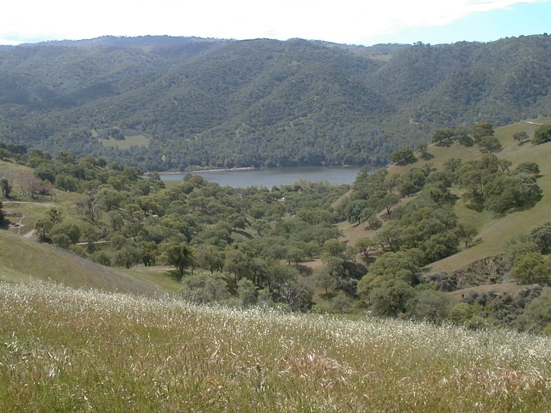
through a lovely valley and climbed a ridge with astonishing views in
every direction. THEN, I entered the park and started hiking, and the
love grew stronger and stronger. I know I will return again, for the great
trails, views, and... well, great everything.
Del Valle, a man-made reservoir, offers
 other recreation opportunities beyond hiking. The lake is stocked with
trout from October to May (there's also catfish and bass), and if fishing
isn't your thing, you can take a dip in the water, or launch a boat or
sailboard. When you've had your fill of activities, there are campsites
at Del Valle, both hike-in group sites and drive-in family ones. Serious
hikers will note that entry into Ohlone Regional Wilderness is afforded from Del Valle's
southern tip. Beginning hikers might appreciate a gentle stroll
to the Hetch Hetchy Group Camp along the mostly level East Shore Trail,
a 3-mile out-and-back jaunt. For all hikers a variety of easy to moderate
loop hikes can be found. Most loops will combine the level East Shore
Trail with an ascending trail, follow with a stint on one of a handful
of gently rollercoastering paths, and then finish with a descent back
to the parking area. Almost all of the trails at Del Valle are wide, multi-use
fire roads.
other recreation opportunities beyond hiking. The lake is stocked with
trout from October to May (there's also catfish and bass), and if fishing
isn't your thing, you can take a dip in the water, or launch a boat or
sailboard. When you've had your fill of activities, there are campsites
at Del Valle, both hike-in group sites and drive-in family ones. Serious
hikers will note that entry into Ohlone Regional Wilderness is afforded from Del Valle's
southern tip. Beginning hikers might appreciate a gentle stroll
to the Hetch Hetchy Group Camp along the mostly level East Shore Trail,
a 3-mile out-and-back jaunt. For all hikers a variety of easy to moderate
loop hikes can be found. Most loops will combine the level East Shore
Trail with an ascending trail, follow with a stint on one of a handful
of gently rollercoastering paths, and then finish with a descent back
to the parking area. Almost all of the trails at Del Valle are wide, multi-use
fire roads.
While the place can get hopping in the
summer, it's pretty peaceful in the winter. In fact, winter is my favorite
time to visit Del Valle. Autumn is pretty, but dry and hot. Spring wildflowers
are disappointing compared to nearby Sunol, Morgan Territory, and Pleasanton Ridge, and in summer
locals make heavy use of the boating and swimming opportunities. The sounds
of motor boats and parties travel surprisingly far. While the trails are
usually muddy in winter, it's much more peaceful and quiet than any other
season.
For the featured hike, start from the Marina parking lot, walk west toward the reservoir and take the paved trail to the right. If it's a quiet
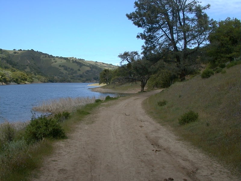 day at the park, you may cross paths with some of the many common birds
who call Del Valle home, such as crows, vultures, ducks, and geese. These
birds congregate in the trees and along the shores of the lake, and fly
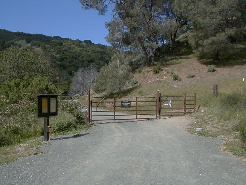
away with squawking protests as you stroll by. At the edge of the parking
lot near the boat launch, go through the gate which
marks the start of the real, dirt multi-use trail. You may notice blue
oaks, pines and, on the hillside to the right, lots of California sagebrush and some paintbrush (I often
see these two plants growing together). On a hike in February I stopped
for a while to watch a sapsucker attack the bark of an blue oak tree.
Further down the path, a flock of small ducks snuck up behind me and conducted
a precise flyover that would have done the Blue Angels proud. In spring,
sprinklings of bluedicks, filaree, and California buttercup are common,
but I've never seen any flower blooming in abundance. A faint path sweeps
to the right along the confluence of two streams at 0.45 mile. You might
notice one of the park's many squirrel burrows on both sides of the trail.
At 0.6 mile, just before the Hetch Hetchy Group Camp, you'll arrive at a signed
junction. Hetch Hetchy Trail climbs uphill here. East Shore continues
to stretch along the water's edge all the way to the north tip of the
lake. (If you want to extend your hike, continue on East Shore to the
junction with Ridgeline, take a right and continue on Ridgeline for the
remainder of the hike.) For the featured hike, turn right onto Hetch Hetchy Trail.
day at the park, you may cross paths with some of the many common birds
who call Del Valle home, such as crows, vultures, ducks, and geese. These
birds congregate in the trees and along the shores of the lake, and fly
away with squawking protests as you stroll by. At the edge of the parking
lot near the boat launch, go through the gate which
marks the start of the real, dirt multi-use trail. You may notice blue
oaks, pines and, on the hillside to the right, lots of California sagebrush and some paintbrush (I often
see these two plants growing together). On a hike in February I stopped
for a while to watch a sapsucker attack the bark of an blue oak tree.
Further down the path, a flock of small ducks snuck up behind me and conducted
a precise flyover that would have done the Blue Angels proud. In spring,
sprinklings of bluedicks, filaree, and California buttercup are common,
but I've never seen any flower blooming in abundance. A faint path sweeps
to the right along the confluence of two streams at 0.45 mile. You might
notice one of the park's many squirrel burrows on both sides of the trail.
At 0.6 mile, just before the Hetch Hetchy Group Camp, you'll arrive at a signed
junction. Hetch Hetchy Trail climbs uphill here. East Shore continues
to stretch along the water's edge all the way to the north tip of the
lake. (If you want to extend your hike, continue on East Shore to the
junction with Ridgeline, take a right and continue on Ridgeline for the
remainder of the hike.) For the featured hike, turn right onto Hetch Hetchy Trail.
The broad fire road, open to hikers, cyclists,
and equestrians, creeps uphill through grassland occasionally studded
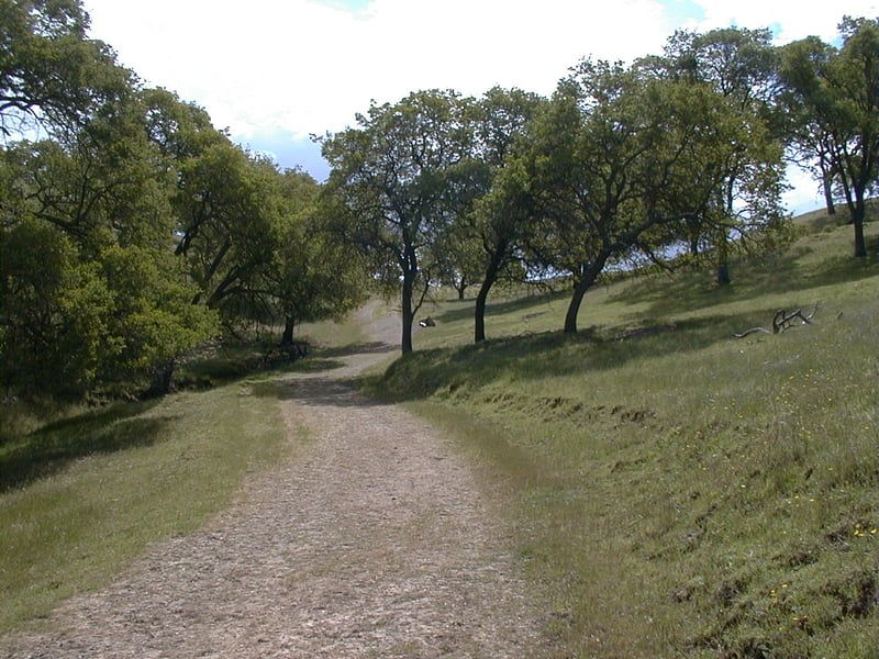 with blue oaks. Cows graze in the park, so the surface may be muddy. You
might see redtails hawks soaring above the grassland. With so many squirrels
standing dumbly about, the hawks are bound to carry some off, but these
shy birds probably won't stick around if you linger. As you climb, look
back for stunning views of Tarantula Cove (no, I've never seen the big
furry crawling critters here, but they are commonly spotted in the East
Bay hills in autumn), and the west ridge. After winter storms, the water
might look muddy, while in spring it's a cheerful azure. At the crest,
a thoughtfully placed bench provides a nice rest stop. A few steps later,
signed junction marks off 1 mile. Here Hetch Hetchy Trail continues
straight, on its way to meet up with Ridgeline Trail. Take the
trail to the right, signed "to Hidden Canyon Trail."
with blue oaks. Cows graze in the park, so the surface may be muddy. You
might see redtails hawks soaring above the grassland. With so many squirrels
standing dumbly about, the hawks are bound to carry some off, but these
shy birds probably won't stick around if you linger. As you climb, look
back for stunning views of Tarantula Cove (no, I've never seen the big
furry crawling critters here, but they are commonly spotted in the East
Bay hills in autumn), and the west ridge. After winter storms, the water
might look muddy, while in spring it's a cheerful azure. At the crest,
a thoughtfully placed bench provides a nice rest stop. A few steps later,
signed junction marks off 1 mile. Here Hetch Hetchy Trail continues
straight, on its way to meet up with Ridgeline Trail. Take the
trail to the right, signed "to Hidden Canyon Trail."
The path picks its way downhill, with suspicious
squirrels scurrying around the oak-punctuated grassland like frantic Oompah
Loompahs guarding Willy Wonka's candy stashes. Blue oaks continue to dominate
the landscape. At 1.35 miles, the spur trail ends at a junction with Hidden
Canyon Trail. Taking Hidden Canyon Trail to the right is an option that
would stretch your hike a bit, but for the featured hike take Hidden
Canyon Trail to the left.
After a short climb, multi-use Hidden Canyon
Trail sweeps around the corner past a shortcut trail heading sharply uphill.
Continue on Hidden Canyon Trail to a junction at 1.4 miles. Continue straight
on Hidden Canyon Trail, as the path edges near the mini-crevasse on
 the right. After skirting a small pond popular with the cows, Hidden Canyon
Trail ends at a signed junction at 1.5 miles. In February, look for yellow California buttercups, one of the first "spring"wildflowers, in the grass behind the signpost. Take Eagle Crest Trail
to the left, uphill.
the right. After skirting a small pond popular with the cows, Hidden Canyon
Trail ends at a signed junction at 1.5 miles. In February, look for yellow California buttercups, one of the first "spring"wildflowers, in the grass behind the signpost. Take Eagle Crest Trail
to the left, uphill.
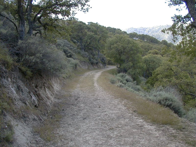
Open to cyclists, hikers, and equestrians,
Eagle Crest Trail climbs somewhat steeply. Along the creekbed on the left
side of the trail, a lone buckeye tree sits among the oaks. Like all buckeyes,
this one pushes out its leaves in late winter, and then waits for the
deciduous oaks to catch up. When the buckeyes bloom in the summer, the
sweet smell can be stupefying. Mistletoe hangs in heavy bunches off oak
branches, living parasitically off the trees. It is easy to pick out in
the winter when these oaks stand denuded. Eagle Crest Trail continues
to climb until it ends at 1.7 miles at a signed junction. Look behind you to the north
to savor views of the beautiful rolling hills. Turn right onto Ridgeline
Trail and climb a bit more to the crest, then a few feet later at
1.8 miles, continue right on Ridgeline at a signed junction with the
East Ridge Trail.
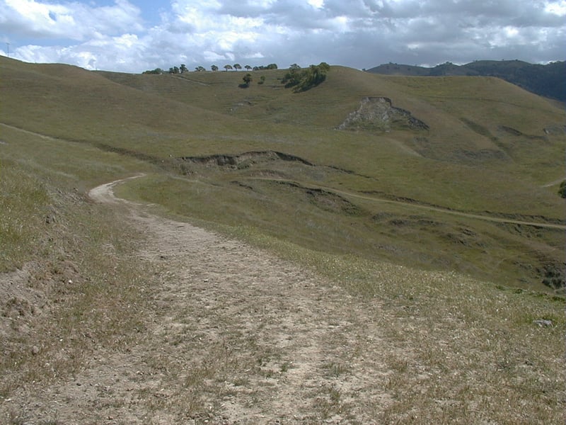
As you gently descend along Ridgeline
Trail, the distant dark forested hills to the east stand in contrast to
the grassy slopes at your feet. The reservoir is often visible to the
right. The hills have sagged and collapsed in portions on the left
side of the trail, and these areas are particularly soggy in the winter.
When it's muddy look for prints from bobcat, coyote, raccoon, skunk, deer,
and perhaps fox. It can get windy along this section of trail, but it's
 also quiet. The only sounds floating your way may be a chattering squirrel,
chirping bird, or the whisper of the wind. At 2.1 miles, the other end
of Eagle Crest Trail ends near a signed junction with Ridgeline Trail. Turn
left on Ridgeline.
also quiet. The only sounds floating your way may be a chattering squirrel,
chirping bird, or the whisper of the wind. At 2.1 miles, the other end
of Eagle Crest Trail ends near a signed junction with Ridgeline Trail. Turn
left on Ridgeline.
You'll descend some more, passing a
small pond off the left side of the trail, crossing through a gate (which
may be seasonally removed), and then climbing to a signed junction at
2.4 miles. (You can take Squirrel Gulch Trail to the right here, or continue
on the featured hike; both options are about the same in mileage.) Continue to
the left on Ridgeline.
The trail begins a descent. In spring,
you might see small amounts of blue-eyed grass, lupine, and owl's clover.
After passing a pond, you'll arrive at a signed junction at 2.9 miles.
The trail to the left ends at Del Valle Road. Continue on Ridgeline
Trail.
California sagebrush reenters the landscape,
underneath the oaks. Bluewitch nightshade and paintbrush may be seen flowering
in spring. After contouring along the hillside, Ridgeline meets up with
Lake View Trail and an unnamed spur at 3.1 miles. Turn right to stay
on Ridgeline.
As you walk downhill, check the skies for
hunting hawks. At 3.3 and 3.4 miles, Ridgeline passes both ends of
East Tank Loop; continue on Ridgeline. Downslope off the right
side of the trail, the hillside descends to a narrow gulch. Cows have
worn a path into the canyon. A lone toyon bush on the right provides a
burst of red color in the winter months. In spring you might see blue
larkspur on the left side of the trail. Ridgeline Trail ends, along with
the terminus of Lake View Trail, at a gate across the street from the
parking lot, at 3.7 miles.
Turn right and walk back along the park road to the Marina parking lot.
Total distance: 3.9 miles
Last hiked: April 18, 2001
Previous visit: February 28, 2000