Many
bay area hikers will never take advantage of Long Ridge Open Space Preserve's most unique feature. Long Ridge's trails connect
to Portola Redwoods State Park, creating a unique opportunity to trek
along hiking-only trails in the eastern section of the state park. However,
it's a long out-and-back journey; starting out at around 2300 feet on
Skyline Boulevard and traveling 1.6 miles downhill to the park's boundary
at around 1900 feet. From there a sturdy hiker can explore Portola Redwoods
for a few miles (descending all the while) before turning around and doubling
back to the trailhead.
If the out-and-back hike to Portola Redwoods State Park is
more than you bargained for, there are other delightful and easier
hikes at Long Ridge, with a few loop options, and a couple of out-and-back
hikes into other adjacent parks and preserves. The Bay Area Ridge Trail
travels north from Long Ridge to
Skyline Ridge Open Space Preserve, and south
through the western edges of Upper Stevens Creek
County Park and Saratoga Gap Open Space Preserve. Either direction
on the Bay Area Ridge Trail is an out-and-back hike. One long, challenging
loop is the combination of Grizzly Flat Trail, Canyon Trail, and an unnamed
hiking only trail through Upper Stevens Creek County Park, followed by
 the Bay Area Ridge Trail (Hickory Oaks, Long Ridge Road, and Peters Creek
Trail), and then finishing up on Peters Creek Trail. This long haul is
a nearly 9-mile loop, with plenty of elevation change along the way.
the Bay Area Ridge Trail (Hickory Oaks, Long Ridge Road, and Peters Creek
Trail), and then finishing up on Peters Creek Trail. This long haul is
a nearly 9-mile loop, with plenty of elevation change along the way.
Loops and semi-loops inside Long Ridge
typically include Peters Creek Trail, Hickory Oaks Trail, and Long Ridge
Road. Hickory Oaks and Long Ridge Road travel through mostly grassland,
while Peters Creek Trail spends a good part of the time in the shade alongside
its namesake.
One surprise at
Long Ridge is how much noise drifts from Skyline Boulevard to the preserve; on a still day you can hear
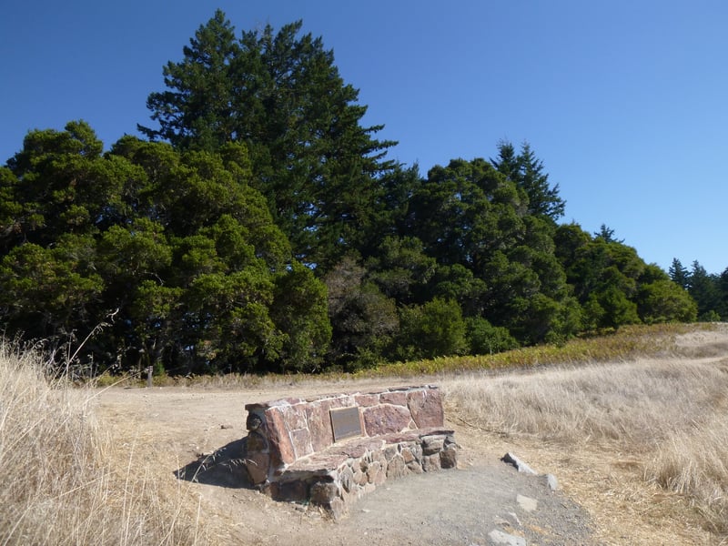
motorcycles and cars on most trails. Luckily one quiet place is the Wallace
Stegner Memorial Bench, which sits near the junction of Long Ridge Road
and Long Ridge Trail. The bench, dedicated in 1996 to Stegner, who lived
nearby in Portola Valley, features amazing views of Butano Ridge and the
ocean.
Long Ridge is renowned for springtime wildflowers.
You can spend the better part of a morning creeping along the trails,
finding flowers in the woods and grassland. By summer the grassland is
dry, but views to the west are usually crystal clear, with none of the
smog that is common on the east side of the Santa Cruz Mountains. Dusty
trails make it easy to track some of the preserve's wild animals, which
include turkeys, feral pigs, and coyotes. There are patches of autumn
color at Long Ridge, and in winter, when trails
are empty (most are closed to horses and bikes during muddy months) the grassland returns to a lush and vibrant green.
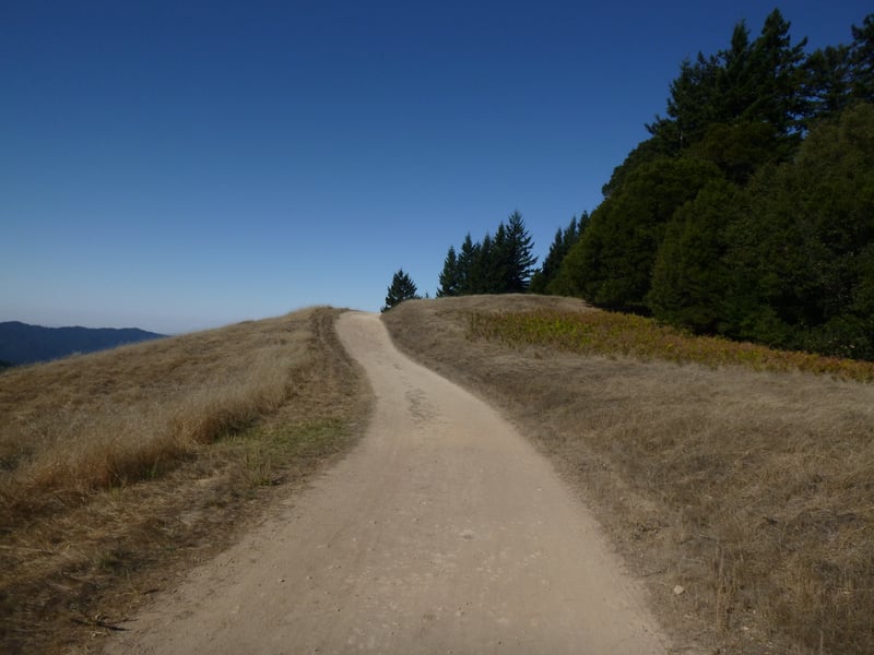
For the featured hike, start at
the Grizzly Flat Trailhead and hike downhill on Peters Creek Trail.
The multi-use trail winds through grassland, where you might see mule-ear
sunflowers, vetch, and California buttercups in late spring. After passing
through a stretch shaded by Douglas fir, madrone, and big-leaf maple,
where springtime flowers include hounds tongue, milkmaids, mission bells,
western heart's ease, starflower, and woodland star, Peters Creek Trail
emerges into grassland at a signed junction at 0.35 mile. The Bay Area
Ridge Trail heads north to the right, on its way to Skyline Ridge Open
Space Preserve. Continue straight on Peters Creek Trail.
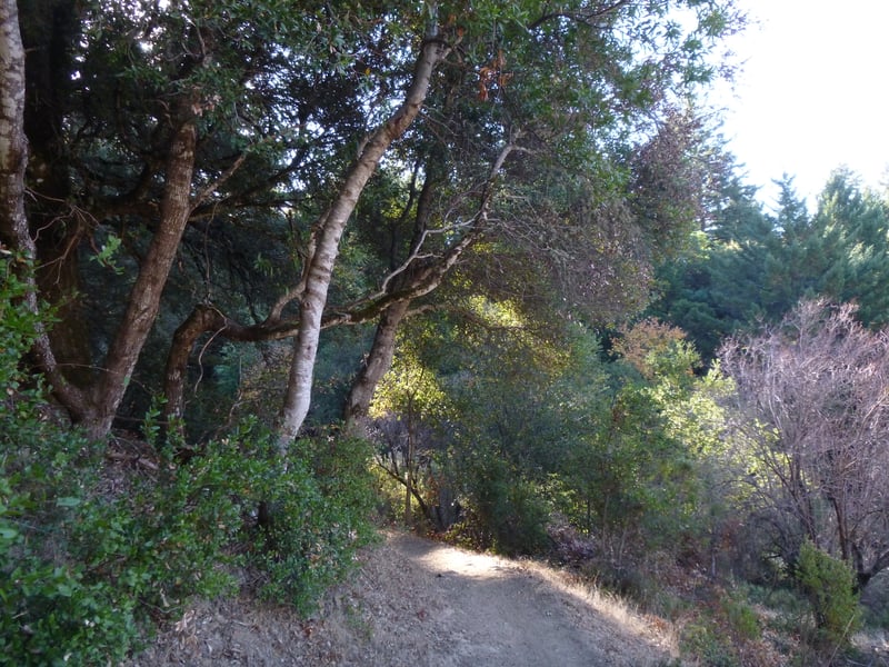
After a few feet, Peters Creek Trail dips
beneath cover of Douglas fir and live oaks, and edges close to Peters
Creek. The path crosses a bridge, then ducks beneath a large fallen Douglas
fir and reaches a signed junction at 0.45 mile. (The hike can head in
either direction from here; continuing on Peters Creek Trail, essentially
taking the rest of the featured hike in reverse, is actually an easier
option.) Turn right onto Long Ridge Trail.
 Right away the climbing is tough, but tall
California bay, live oaks, madrones, and Douglas firs almost completely
shade the trail, which is open to hikers, cyclists, and equestrians. Hazelnut
shrubs, strawberries, common snowberries, and wild roses also flourish
along the cool slopes. As Long Ridge Trail reaches a switchback, the path
levels out dramatically. There's one sunny spot where some felled trees
allow light to filter down to the trail, but most of Long Ridge Trail
is cool and dark. After cresting, the trail actually descends just a bit,
then maintains a mostly level pace. The path runs along private Portola Heights Road, which
is occasionally visible through the thick vegetation. You might notice
overgrown shrubs of poison oak and thimbleberry. Long Ridge Trail briefly
passes through a sunny chaparral patch, with manzanitas, chamise, and
yerba santa, switchbacks downhill slightly, shoots uphill to a clearing,
then approaches a signed junction at 1.1 miles. The trail to the left
heads downhill to Peters Creek Trail; this is an option if you'd like
to cut your hike short. Bear right and continue uphill on Long Ridge
Trail.
Right away the climbing is tough, but tall
California bay, live oaks, madrones, and Douglas firs almost completely
shade the trail, which is open to hikers, cyclists, and equestrians. Hazelnut
shrubs, strawberries, common snowberries, and wild roses also flourish
along the cool slopes. As Long Ridge Trail reaches a switchback, the path
levels out dramatically. There's one sunny spot where some felled trees
allow light to filter down to the trail, but most of Long Ridge Trail
is cool and dark. After cresting, the trail actually descends just a bit,
then maintains a mostly level pace. The path runs along private Portola Heights Road, which
is occasionally visible through the thick vegetation. You might notice
overgrown shrubs of poison oak and thimbleberry. Long Ridge Trail briefly
passes through a sunny chaparral patch, with manzanitas, chamise, and
yerba santa, switchbacks downhill slightly, shoots uphill to a clearing,
then approaches a signed junction at 1.1 miles. The trail to the left
heads downhill to Peters Creek Trail; this is an option if you'd like
to cut your hike short. Bear right and continue uphill on Long Ridge
Trail.
On an easy ascent through madrone, tanoak,
live oaks, and Douglas fir, the path passes some sandstone boulders and
crosses through a few grassy areas on the way to the ridge. In late spring,
look for carpets of lupines, checkerblooms, and clover in the grassland.
Once through a gate (installed to restrict trail
use to cyclists and equestrians in the wet months), Long Ridge Trail steps
out into the grassland and ends at 1.8 miles. Long Ridge Road (to
the left) is the only trail option from here, but first visit the Wallace
Stegner Memorial Bench, a few steps away from the junction.
The simple stone bench is a fantastic rest
stop, with unobstructed views to the west and southwest of the forested
mountains receding toward the ocean. In early spring, a riot of flowers
dot the grass, but even in late spring, a few California poppies, checkerblooms,
scarlet pimpernels, redmaids, lupines, and clovers persist. Wallace Stegner,
author of Big Rock Candy Mountain and Angle of Repose (two
of the best western novels ever written, in my opinion), was an advocate
for the preservation of open space in the Santa Cruz Mountains, and a
quote of his is inscribed on a plaque affixed to the bench. One of my visits to Long Ridge was four years to the day of the bench's dedication,
which I didn't realize until I was editing the photos. When you're ready
to continue, head east on Long Ridge Road.
A few live oaks and Douglas
fir line this wide fire road, which is open to cyclists, equestrians,
and hikers, but grassland dominates the landscape. Long Ridge Road winds
levelly along, with small changes in the elevation that are barely noticeable,
 particularly if you find yourself captivated by the vistas. There's a
well-worn path off the right side of the trail; it loops back to join
Long Ridge Road after a few feet, and it's a fine spot to take one last
lingering look west before heading back downhill. On a summer hike, I
noticed turkey prints on the trail, and I followed them as they wandered
on and off the trail for almost 1/2 mile. Finally, just past Peters Creek
Trail, I saw them strutting up the fire road: three large turkeys just
strolling along. Although I was as quiet as possible,
they soon acknowledged my presence by leaving the trail and entering the
woods. At 2.25 miles, you'll reach a signed multi-trail junction. (If
you'd like to extend your hike a bit more, you could turn right onto Ward
Road, then take Hickory Oaks Trail and turn left when you reach Long Ridge
Road again. This option adds about 1.2 miles to the featured hike. You
can also continue straight on Long Ridge Road, which dumps into Hickory
Oaks, and turn back when you wish, retracing your steps to this junction.) Turn left onto Peters
Creek Trail.
particularly if you find yourself captivated by the vistas. There's a
well-worn path off the right side of the trail; it loops back to join
Long Ridge Road after a few feet, and it's a fine spot to take one last
lingering look west before heading back downhill. On a summer hike, I
noticed turkey prints on the trail, and I followed them as they wandered
on and off the trail for almost 1/2 mile. Finally, just past Peters Creek
Trail, I saw them strutting up the fire road: three large turkeys just
strolling along. Although I was as quiet as possible,
they soon acknowledged my presence by leaving the trail and entering the
woods. At 2.25 miles, you'll reach a signed multi-trail junction. (If
you'd like to extend your hike a bit more, you could turn right onto Ward
Road, then take Hickory Oaks Trail and turn left when you reach Long Ridge
Road again. This option adds about 1.2 miles to the featured hike. You
can also continue straight on Long Ridge Road, which dumps into Hickory
Oaks, and turn back when you wish, retracing your steps to this junction.) Turn left onto Peters
Creek Trail.
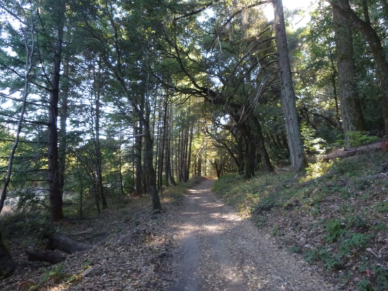
After passing through another seasonal
closure gate, the multi-use trail gently switchbacks downhill through
madrone, oaks, and Douglas fir. Creambush, wild rose, poison oak, and
common snowberries all can be found on the side of the path. Peters Creek
Trail abandons the woods for grassland, where in the spring, California
buttercups, checkerbloom, lupines, and clover bloom. The trail crosses
over a bridge and edges along a pond. The pond and the surrounding land
to the right are private property, so stay on the trail. Peters
Creek Trail makes a sharp turn left at a signed junction with a gated
service road at 2.7 miles. Stay left on Peters Creek Trail.
After ambling levelly through the shade
along Peters Creek for a while, the trail crosses the stream and cuts
through patches of grassland. Poison hemlock is common, along with more
benign plants such as columbine, currant, nettles, horsetail, and cow
parsnip. At 3 miles, two legs of an unmarked trail break off from Peters
Creek Trail; the path ends at a pullout on Skyline Boulevard. Continue
straight on Peters Creek Trail.
A few trees survive in an old orchard off
the right side of the trail; look for walnuts and apples in late summer.
Closer to the ground, strawberry and blackberry plants put out blossoms
in the spring and then fruit in the summer. Ripe blackberries are easy
to find, but it takes luck and sharp vision to find ripe wild strawberries. At 3.3 miles, you'll reach
a signed junction. The trail to the left heads uphill to join Long Ridge
Trail (you passed the other end of it earlier). Bear right and continue
on Peters Creek Trail.
This is a pretty and quiet segment. Wildflowers,
including blue-eyed grass, bluedicks, and California buttercup thrive
in the grass along the trail. In May I was delighted to see a large clump
of false baby stars off the left side of the trail. Peters Creek Trail
transitions to woodland, and resumes a course along the creek. Ferns and
moss-covered rocks line the path. At 3.65 miles, you'll reach a previously
encountered junction with Long Ridge Trail. Stay to the right on Peters
Creek Trail, and then retrace your steps back to the trailhead.
Total distance: 4.1 miles
Last hiked: October 22, 2013
Previous visits: August 31, 2001 and May 19, 2000