With
so much open space land in the south bay, it's easy to forget about
the cluster of parks in southern San Mateo County, comprised of Sam
MacDonald County Park, San Mateo County Memorial
Park, Pescadero Creek County Park, and Portola Redwoods State Park.
On the northern peninsula, Purisima Creek Redwoods
Open Space Preserve, a short drive from San Francisco, is a popular
destination for viewing Sequoia sempervirens, and Santa Cruz County's
Big Basin Redwoods State Park is a well-known
redwood tourist destination. Geographically in between these two parks,
Portola State Park and the collection of San Mateo County Parks are relatively
quiet. All feature plenty of facilities (camping in Portola, picnic areas
and camping in the county parks), but away from the campgrounds and picnic
tables, you're likely find desolate redwoods groves and nearly empty trails.
The partnership between Pescadero Creek County Park and Portola Redwoods
State Park is particularly pleasant. Trails are well-signed, San Mateo
County provides maps on signboards at the bordersbetween
the two parks, and Portola's map thoughtfully includes a large hunk of
the county park's eastern portion (and trails). Portola, in my experience,
is one of the best-staffed state parks in the bay area. The staff takes
great pride in the park, and trails are meticulously maintained, which
is all the more impressive when you consider how this park, nestled in
a canyon, gets pounded by winter storms. (Check out their display in the
Visitor Center for photos showing what a bad storm season does to these
 parts.)
From this trailhead, dayhikers can explore
Portola State Park in conjunction with Pescadero Creek County Park, or
stay within the confines of the state park. Loops are possible either
way. The Sequoia Nature Trail is a short and easy self-guided nature loop
through redwoods and along Pescadero Creek, perfect for families with
small kids. Peters Creek Loop, a grueling 13-mile semi-loop hike, should
provide a challenge for experienced hikers. For a more moderate choice, Coyote Ridge Trail, Upper Coyote Ridge Trail, Tarwater
Loop Trail, and Pomponio Trail, make an over 6 mile trek through both Portola
and Pescadero Creek parks.
Portola's strategic location allows for long
backpacking excursions as well as dayhikes. Hikers can start at Long
Ridge Open Space Preserve, on Skyline Boulevard, hike west into Portola,
camp, then hike through Pescadero Creek County Park and south into Big
Basin. Incredibly, backpackers have the ability to turn this into a loop
hike; from Big Basin you can hike uphill on the Skyline to the Sea Trail,
camp in Castle Rock, then trek north through
Saratoga Gap Open Space Preserve, Upper Stevens Creek
County Park, and return to Long Ridge Open Space Preserve.
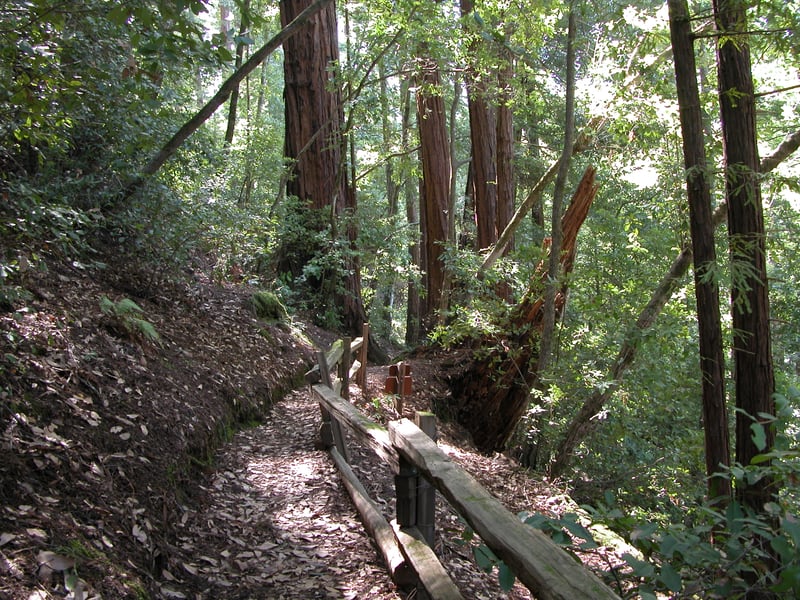
For this featured hike begin from the
side of the Ranger Station, on signed Sequoia Nature Trail. The path
descends slightly through redwood, tanoak, and huckleberry, then
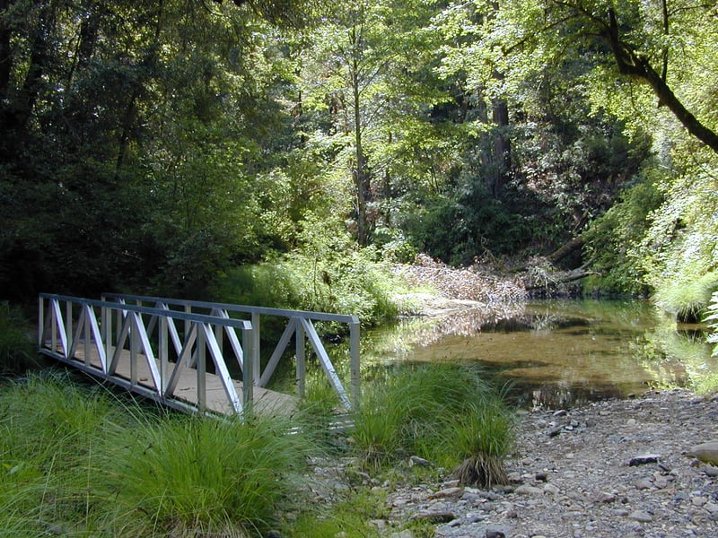
bends right and drops to the banks of Pescadero Creek. Use the bridge
to cross the creek, then walk along the bank until the trail ascends
a few steps and soon reaches a junction at 0.2 mile. Bear left,
following the sign toward Iverson Trail. Where the other leg of
Sequoia Nature Trail feeds in from the right, stay to the left. The
trail rises a bit to a T-junction with Iverson Trail at 0.3
mile. Turn left onto Iverson to begin the first of the hike’s two
out-and-back segments, ascending through a forest of redwood, tanoak,
madrone, and huckleberry.The hillside drops sharply off to the left
where the trail runs high above Pescadero Creek, so step carefully.
At 0.5 mile, where a path heads off to the left and down to the
creek, stay to the right. This area can be bogged down by winter
rains, and somewhat overgrown in summer. Iverson Trail steps over a
stream, then reaches a junction at 0.6 mile, where you’ll turn
right and climb briefly and easily to Tiptoe Falls. Although the
falls cascade only a few feet before spilling into a pool, Tiptoe
Falls is a pretty and calm place that can relax and rejuvenate you in
the way that only rushing water can. When you’re ready, retrace
your steps back to the junction with Iverson Trail and the connector
to Sequoia Nature Trail at 0.9 mile. Continue straight, remaining on
Iverson Trail.
The trail
descends gently to wander along the forest floor. Wildflowers
that bloom here throughout spring include starflower, redwood sorrel,
milkmaids, and trillium. The trail drops to the shores of Pescadero
Creek and, once again, you’ll cross on a bridge. On the other side,
the trail ascends a bit on some steps, then reaches a junction at 1.2
 miles. Turn left onto Pomponio Trail. At a nearly flat grade,
Pomponio Trail follows the general course of Pescadero Creek,
although the distance precludes views of the water. The forest
understory is particularly dense here, with huckleberry thickets
squeezing the trail in areas. Huckleberry is an evergreen shrub
common to redwood canyons. Its fruit, which somewhat resembles
blueberries, ripens in some parts of the Bay Area by late summer.
Along this trail, they aren’t usually edible until October—the
seasons seem to
arrive late at Portola.
miles. Turn left onto Pomponio Trail. At a nearly flat grade,
Pomponio Trail follows the general course of Pescadero Creek,
although the distance precludes views of the water. The forest
understory is particularly dense here, with huckleberry thickets
squeezing the trail in areas. Huckleberry is an evergreen shrub
common to redwood canyons. Its fruit, which somewhat resembles
blueberries, ripens in some parts of the Bay Area by late summer.
Along this trail, they aren’t usually edible until October—the
seasons seem to
arrive late at Portola.
With a transition
marked by signs facing both directions, Pomponio Trail leaves the
state park and enters Pescadero Creek County Park. In summer, you
might see fairy lanterns along the trail, and by autumn, honeysuckle
berries dangle from vines twined through trees and shrubs. Madrone,
California bay, creambush, toyon, ceanothus, and wild rose succeed
huckleberry as the trail widens and passes through a slightly sunnier
area. Where there are breaks in the forest, you can actually see the
surrounding forest of Douglas fir and redwood towering above the
trail. At 2.2 miles, Pomponio Trail ends at a junction with Bridge
Trail. The path straight across leads to Tarwater Trail
Camp.
Turn left onto a
broad fire road that is level until it drops a short distance to
cross Pescadero Creek. Tanoak, redwood, Douglas fir, and big-leaf
maple line the trail, which begins a moderate climb. At 2.5 miles,
pass Snag Trail on the right and continue straight on Bridge Trail.
Now nearly level again, Bridge Trail passes a damp, tree-lined meadow
on the right, then ends at 2.8 miles. Continue left, now on Old Haul
Road. Almost right away, Ridge Trail begins on
the right. That trail climbs about 1,500 feet in a little more than 2
miles, then leaves the county park and heads toward Big Basin
Redwoods State Park via an easement trail connection. For now, keep
an easy pace straight ahead on Old Haul Road.On the high south bank
of Pescadero Creek, Old Haul Road passes through redwood,
huckleberry, creambush, Douglas fir, and tanoak.In winter months,
you’ll likely hear water rushing as feeder creeks flow downhill on
the way to Pescadero Creek. The largest of these streams, Fall Creek,
tumbles into Tiptoe Falls a short distance off to the left but is
inaccessible from the fire road. At 4.1 miles, Portola Trail and
Iverson Creek drop to the fire road from the right, and a service
road descends on the left. Turn left onto the service road. Now back
in the state park, you’ll begin a somewhat steep descent. Iverson
Trail begins on the left, but this segment of the trail has been
perennially plagued with landslides. Slightly downhill from the
junction with Iverson sits the remains of Iverson’s cabin. This
little redwood structure was built in the 1860s and remained intact
until the 1989 earthquake toppled it.
The service road
 winds downhill to a junction at 4.5 miles. If you’re already tired,
this is your opportunity to bail on the remaining hike. Simply follow
the service
road back to the trailhead. Otherwise, turn right onto Summit Trail. Initially,
Summit Trail is a broad fire road, but once past a pair of water
tanks, the trail shrinks to a footpath. At a moderate grade, the
trail ascends through an assortment that by now should be familiar:
Douglas fir, redwood, tanoak, madrone, and huckleberry. If you arrive
in late winter hoping for wildflowers, you’ll probably be
disappointed; instead look for a variety of colorful mushrooms. Wild
rose is really the only understory plant here besides huckleberry to
make a statement.
winds downhill to a junction at 4.5 miles. If you’re already tired,
this is your opportunity to bail on the remaining hike. Simply follow
the service
road back to the trailhead. Otherwise, turn right onto Summit Trail. Initially,
Summit Trail is a broad fire road, but once past a pair of water
tanks, the trail shrinks to a footpath. At a moderate grade, the
trail ascends through an assortment that by now should be familiar:
Douglas fir, redwood, tanoak, madrone, and huckleberry. If you arrive
in late winter hoping for wildflowers, you’ll probably be
disappointed; instead look for a variety of colorful mushrooms. Wild
rose is really the only understory plant here besides huckleberry to
make a statement.
Curve left with
Summit Trail as it travels across the sloping walls of a canyon. At
one point, the trail crosses over the top of a tiny ridge, then
continues to contour across the hillside. A pretty wooded knoll
extends off to the right. What’s
marked on the map as “the summit,” the highest point on this
loop, doesn’t quite live up to its name. You’ll know you’re there when you spot
a handful of chamise and manzanita shrubs. There are no views, and
this tiny hilltop has barely enough room for a group of three to sit.
However, it’s a peaceful spot to pause and listen to the wind sweep
through the trees. Summit Trail descends, curves left, then levels
out on a ridge and ends at 5.3 miles. At this junction, bear left
onto Slate Creek Trail, which leads back to the Ranger Station
trailhead. An easy descent commences. In some places, redwood needles
and tanoak leaves cover the trail in a cushy carpet. Many of the tree
trunks here are charred from
a long-ago fire. Yellow banana
slugs, if you happen to encounter them, really stand out in this
forest of brown and green.
Continuing to loop
around the canyon, Slate Creek Trail weaves through a quiet forest
where birdcalls filter through
the air. Just past a memorial grove sign, look on the right for a
bench nestled in the middle of a redwood fairy ring—an excellent
lunch stop. Soon after, at 6.2 miles, a path to
the campground departs on the right. Continue to the left on Slate
Creek Trail, traverse a short, steep downhill section on some stairs,
and then return to a gentle grade. Moss-covered tree stumps and
evergreen plants create an incredibly lush atmosphere. Slate Creek
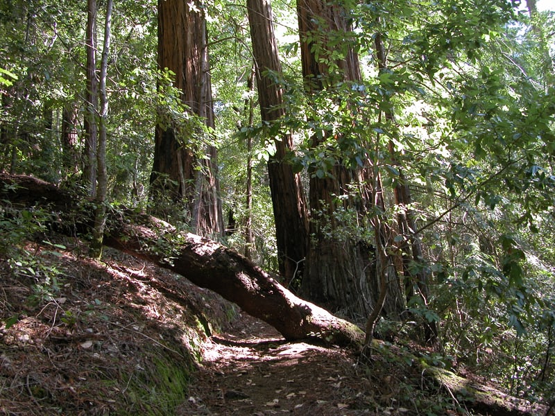
Trail passes through a massive fallen redwood, then reaches a
junction at 6.6 miles, where you’ll turn left onto Old Tree Trail
for a short out-and-back. Passing a huge fallen tree lying on the
right, Old Tree Trail makes its way into the heart of the canyon at
an easy incline, following along a seasonal creek. Western wood
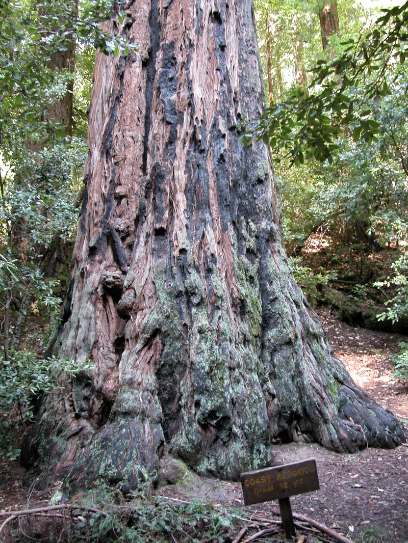
anemone bloom here in late winter. At 6.9 miles, you’ll reach the
end of the trail and the trail’s namesake, an old tree. Cradled in
a deep canyon, this redwood has a circumference of more than 12 feet
and seems to scrape the sky. When you’re ready, walk back to the
junction with Slate Creek Trail, then continue straight. The wide
path descends gently, then ends at 7.3 miles at the park road. Turn
right and walk the remaining 0.1 mile along the road to the Ranger
Station.
Note: the
park is sometimes closed after heavy storms, so during winter check
trail conditions with park staff before leaving home. At the start of the rainy season, bridges are removed from trails that
cross Pescadero Creek. If the bridges are out and the creek is high,
start your hike on Iverson Trail, across from Madrone Picnic Area
parking lot, and omit the trip to Tiptoe Falls.<
Total distance
: about 7.4 miles
Last hiked: March 6, 2003
Previous visits: June 3, 2002 and August 11, 2000